Old Maps of Rust Op Twist, Saint Croix District
Explore 3 old maps of Rust Op Twist, spanning from 1958 to today. These high-resolution historic maps reveal how streets, neighborhoods, landmarks, and natural features evolved over time — perfect for genealogy, metal detecting, research, and local history exploration.
What you can do with these maps:
- See how Rust Op Twist changed over time: Compare historical maps to modern-day views to trace roads, homesites, rail lines & more.
- View detailed metadata: Each map includes creators, publishers, year, scale, and archive source.
- Overlay maps with satellite & LiDAR: Visualize the past alongside modern tools to explore terrain & human change.
- Trusted historical sources: Maps sourced from the USGS, Library of Congress, and other archives.
- Access maps your way: View online, download high-res files, or order prints for personal or research use.
Start exploring old maps of Rust Op Twist to uncover forgotten places, hidden landmarks, and the deep history beneath your feet.
Rust Op Twist, Saint Croix District maps
(3)- 1958 Map of Christiansted, 1959 Print
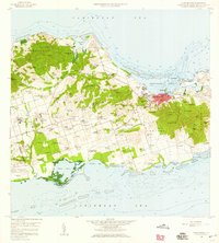 1958 Christiansted1959 Print · USGSSaint Croix's mid-century landscape is captured here just as the island began its modern growth phase. Researchers can trace the layout of Christiansted, locate family names among settlements like Sion Hill and Belvedere, and find landmarks like Kingshill Sch and the Alexander Hamilton Airport.6 unique versions available
 - 2013 Map of Baron Bluff, 2013 Print
 2013 Baron Bluff2013 Print · USGSCovers Rust Op Twist, including Little Fountain, Annaly, and other nearby areas
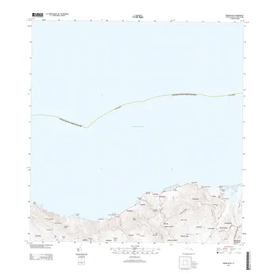
 - 2024 Map of Baron Bluff, 2024 Print
 2024 Baron Bluff2024 Print · USGSSaint Croix's northern coast is mapped here in the early twenty-first century, showcasing its steep ridges and historic estates. Genealogists and historians can trace traditional land names from Annaly to Morningstar and locate the Salt River Bay National Historical Park.
End of results
Showing maps 1-3 of 3
Frequently asked questions
- What are the different types of historical maps available for Rust Op Twist?
- What is the oldest map of Rust Op Twist?
- Where can I purchase historical maps of Rust Op Twist for my home or office?
- Where can I download high-res historical maps of Rust Op Twist?
- Are there historical topographic maps available for Rust Op Twist?
- Is there historical aerial imagery available for Rust Op Twist?
- Where are historical maps of Rust Op Twist sourced from?