Old Maps of Aurora Lodge, Alaska
Explore 8 old maps of Aurora Lodge, spanning from 1949 to today. These high-resolution historic maps reveal how streets, neighborhoods, landmarks, and natural features evolved over time — perfect for genealogy, metal detecting, research, and local history exploration.
What you can do with these maps:
- See how Aurora Lodge changed over time: Compare historical maps to modern-day views to trace roads, homesites, rail lines & more.
- View detailed metadata: Each map includes creators, publishers, year, scale, and archive source.
- Overlay maps with satellite & LiDAR: Visualize the past alongside modern tools to explore terrain & human change.
- Trusted historical sources: Maps sourced from the USGS, Library of Congress, and other archives.
- Access maps your way: View online, download high-res files, or order prints for personal or research use.
Start exploring old maps of Aurora Lodge to uncover forgotten places, hidden landmarks, and the deep history beneath your feet.
Aurora Lodge, AK maps
(8)- 1949 Map of Big Delta B-6, 1956 Print
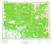
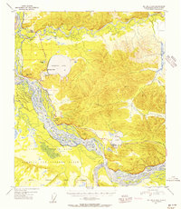 1949 Big Delta B-61956 Print · USGSThe Alaskan interior during the early Cold War era is defined here by the massive footprint of the Ladd Air Force Base Bombing and Gunnery Range. You can trace historical travel routes along the Richardson Highway, stopping at landmarks like Aurora Lodge and the Military Rest Camp (Aban'd) at Birch Lake.6 unique versions available
 - 1950 Map of Big Delta, 1956 Print
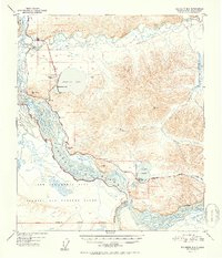
 1950 Big Delta1956 Print · USGSAlaska's interior corridors reveal a landscape of military outposts and river-valley lodges in the mid-twentieth century. Trace historic routes along the Richardson Highway to find Big Delta, Fort Greely, and Shaw Creek Lodge.2 unique versions available
 - 1951 Map of Big Delta
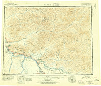 1951 Big Delta1951 Print · USGSThe interior of Alaska is captured at a critical junction during the post-war era as the highway system expanded. Genealogists and historians can trace early roadside landmarks like Aurora Lodge, Tenderfoot, and the original settlement layout of Big Delta.4 unique versions available
 - 1952 Map of Big Delta B-6
 1952 Big Delta B-61952 Print · USGSInterior Alaska in the early fifties shows a landscape of braided river valleys and growing recreational outposts along the Richardson Highway. Trace the evolution of the Ladd Air Force Base Bombing and Gunnery Range and find historic roadside stops like Aurora Lodge and Silver Fox Lodge.2 unique versions available
 - 1958 Map of Big Delta, 1966 Print
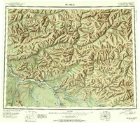
 1958 Big Delta1966 Print · USGSInterior Alaska at the height of the mid-century expansion reveals a landscape of strategic military outposts and remote river settlements. Trace the junction of the Tanana River and the Richardson Highway near Big Delta and the Healy Lake Indian Village.6 unique versions available
 - 1992 Map of Big Delta B-6 NW
 1992 Big Delta B-6 NW1992 Print · USGSThe Tanana and Salcha rivers converge in this early nineties survey of a popular Alaskan recreation corridor. Trace the development of Harding Lake and its state recreation area, or locate landmarks like Aurora Lodge and the Richardson Highway.
 - 2013 Map of Big Delta B-6 NW, 2013 Print
 2013 Big Delta B-6 NW2013 Print · USGSCovers Aurora Lodge, including Harding Lake, Fairbanks North Star, and other nearby areas
 - 2021 Map of Big Delta B-6 NW, 2021 Print
 2021 Big Delta B-6 NW2021 Print · USGSFairbanks North Star Borough comes alive in this study of the Salcha and Tanana river country during the early twenty-first century. Researchers can trace historic travel routes like the Old Valdez Trail and find local landmarks such as Aurora Lodge, Scotts Airport, and Harding Lake.
End of results
Showing maps 1-8 of 8
Frequently asked questions
- What are the different types of historical maps available for Aurora Lodge?
- What is the oldest map of Aurora Lodge?
- Where can I purchase historical maps of Aurora Lodge for my home or office?
- Where can I download high-res historical maps of Aurora Lodge?
- Are there historical topographic maps available for Aurora Lodge?
- Is there historical aerial imagery available for Aurora Lodge?
- Where are historical maps of Aurora Lodge sourced from?