Old Maps of Twin Peaks, Matanuska-Susitna
Explore 9 old maps of Twin Peaks, spanning from 1951 to today. These high-resolution historic maps reveal how streets, neighborhoods, landmarks, and natural features evolved over time — perfect for genealogy, metal detecting, research, and local history exploration.
What you can do with these maps:
- See how Twin Peaks changed over time: Compare historical maps to modern-day views to trace roads, homesites, rail lines & more.
- View detailed metadata: Each map includes creators, publishers, year, scale, and archive source.
- Overlay maps with satellite & LiDAR: Visualize the past alongside modern tools to explore terrain & human change.
- Trusted historical sources: Maps sourced from the USGS, Library of Congress, and other archives.
- Access maps your way: View online, download high-res files, or order prints for personal or research use.
Start exploring old maps of Twin Peaks to uncover forgotten places, hidden landmarks, and the deep history beneath your feet.
Twin Peaks, Matanuska-Susitna maps
(9)- 1951 Map of Anchorage
 1951 Anchorage1951 Print · USGSMid-century Anchorage and the Matanuska Valley are seen here during a period of rapid strategic growth. Trace the development of Fort Richardson, early rail stops at Wasilla, and established mining operations like the Independence Mine or Premier Mine.4 unique versions available
 - 1960 Map of Anchorage B-6, 1961 Print
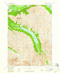 1960 Anchorage B-61961 Print · USGSAlaska's Chugach mountain valleys come into focus in the early sixties as hydroelectric and transport infrastructure began to shape the region. Trace the historic route of the Alaska Railroad past the Eklutna Powerhouse and up to Eklutna Lake.5 unique versions available
 - 1962 Map of Anchorage, 1966 Print
 1962 Anchorage1966 Print · USGSThe Anchorage bowl and Matanuska Valley appear in this mid-century survey during a period of significant military and industrial expansion. Researchers can trace the Alaska Railroad through Sutton and Jonesville or locate historic stops like Meekins Roadhouse and the Watertower Inn.6 unique versions available
 - 1979 Map of Anchorage B-6 NW
 1979 Anchorage B-6 NW1979 Print · USGSThe Matanuska-Susitna region in the late seventies is shown here as a vital corridor for transportation and energy between the peaks and the river. Trace the old routes of The Alaska Railroad and the Glenn Highway past Eklutna Powerhouse toward Eklutna Lake.2 unique versions available
 - 1979 Map of Anchorage, 1980 Print
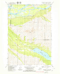
 1979 Anchorage1980 Print · USGSThe Anchorage bowl and Matanuska Valley appear in the late seventies as the region's transportation and military infrastructure matured. Genealogists and historians can trace rail and road evolution through Wasilla, the Matanuska Branch line, and Jonesville.
 - 1994 Map of Anchorage B-6, 2002 Print
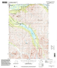 1994 Anchorage B-62002 Print · USGSThe northern Chugach wilderness meets modern infrastructure in this mid-century survey of the Chugach and Matanuska-Susitna boundary. Trace the vital water and power systems of Eklutna Lake, including the Eklutna Dam, Eklutna Powerhouse, and the Bold Airport.
 - 2016 Map of Anchorage B-6 NW, 2016 Print
 2016 Anchorage B-6 NW2016 Print · USGSCovers Twin Peaks, including Matanuska-Susitna, Anchorage, and other nearby areas
 - 2021 Map of Anchorage B-6 NW, 2021 Print
 2021 Anchorage B-6 NW2021 Print · USGSCovers Twin Peaks, including Matanuska-Susitna, Anchorage, and other nearby areas
 - 2023 Map of Anchorage B-6 NW, 2023 Print
 2023 Anchorage B-6 NW2023 Print · USGSThe Matanuska-Susitna and Anchorage border region is captured here in the early twenty-first century as it meets the northern wilderness. Researchers and hikers can trace the paths around Eklutna Lake or locate commemorative high points like Mt POW/MIA and Gold Star Peak.
End of results
Showing maps 1-9 of 9
Frequently asked questions
- What are the different types of historical maps available for Twin Peaks?
- What is the oldest map of Twin Peaks?
- Where can I purchase historical maps of Twin Peaks for my home or office?
- Where can I download high-res historical maps of Twin Peaks?
- Are there historical topographic maps available for Twin Peaks?
- Is there historical aerial imagery available for Twin Peaks?
- Where are historical maps of Twin Peaks sourced from?