Old Maps of Sun Terrace, Concord
Explore 44 old maps of Sun Terrace, spanning from 1896 to today. These high-resolution historic maps reveal how streets, neighborhoods, landmarks, and natural features evolved over time — perfect for genealogy, metal detecting, research, and local history exploration.
What you can do with these maps:
- See how Sun Terrace changed over time: Compare historical maps to modern-day views to trace roads, homesites, rail lines & more.
- View detailed metadata: Each map includes creators, publishers, year, scale, and archive source.
- Overlay maps with satellite & LiDAR: Visualize the past alongside modern tools to explore terrain & human change.
- Trusted historical sources: Maps sourced from the USGS, Library of Congress, and other archives.
- Access maps your way: View online, download high-res files, or order prints for personal or research use.
Start exploring old maps of Sun Terrace to uncover forgotten places, hidden landmarks, and the deep history beneath your feet.
Sun Terrace, Concord maps
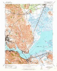
(44)- 1896 Map of Carquinez Strait, 1954 Print
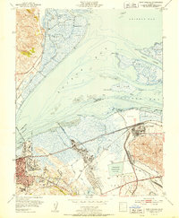
 1896 Carquinez Strait1954 Print · USGSThe industrial waterfront of the Carquinez Strait comes alive in the 1890s, where shipping channels meet the rails. Genealogists and historians can trace early bay settlements from the U.S. Arsenal at Benicia to the rail hubs of Vallejo and Martinez.
 - 1897 Map of Concord
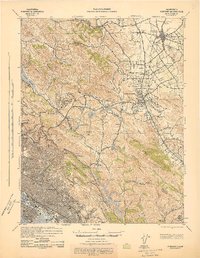
 1897 Concord1897 Print · USGSThe East Bay hills and valleys appear here in the late nineteenth century, just as railroads began to reshape the old rancho lands. Researchers can trace the original tracks of the California and Nevada R. R. and early settlements like Pacheco and Lafayette.6 unique versions available
 - 1898 Map of Karquines
 1898 Karquines1898 Print · USGSThe Karquines Strait and Suisun Bay served as a bustling maritime and rail crossroads in the late nineteenth century. Researchers can trace the early layouts of Benicia, Vallejo, and Martinez, or locate vanished landmarks like Seal Bluff Landing and the U.S. Arsenal.
 - 1901 Map of Karquines
 1901 Karquines1901 Print · USGSNorthern California at the dawn of the twentieth century shows a landscape defined by the deep-water Karquines Strait and industrial rail hubs. Researchers can trace the waterfront activity of Benicia, Vallejo, and Martinez or the tidal marsh outposts at Drawbridge and Rush Landing.6 unique versions available
 - 1902 Map of Napa
 1902 Napa1902 Print · USGSThe Napa Valley and Carquinez Strait are captured at the turn of the century, showing a landscape defined by maritime military posts and early vineyards. Genealogists and historians can trace the Mare Island Navy Yard, the Insane Asylum, and rail stops at Zinfandel and Rutherford.6 unique versions available
 - 1915 Map of Concord
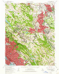
 1915 Concord1915 Print · USGSContra Costa and Alameda counties are shown here just before the mid-century population boom, when the East Bay was a landscape of ranchos and rail stops. Genealogists can trace family footprints in small 1910s settlements like Moraga, Pacheco, and Lafayette.5 unique versions available
 - 1940 Map of Carquinez Strait, 1963 Print
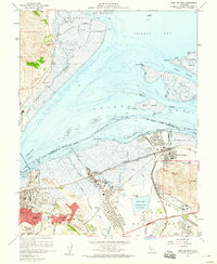
 1940 Carquinez Strait1963 Print · USGSThe industrial waterfronts of Solano and Contra Costa counties are captured here just before the mid-century boom. Genealogists and historians can trace the rail-and-water networks of Port Costa, Benicia, and Vallejo, or locate landmarks like the Carquinez Cem and the Benicia Auto Ferry.2 unique versions available
 - 1942 Map of Concord
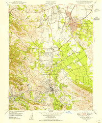
 1942 Concord1942 Print · USGSThe East Bay interior was a landscape of expanding valley towns and deep-rooted ranching tracts in the early 1940s. Genealogists and historians can trace rail-era settlements like Concord, Lafayette, and Walnut Creek alongside local landmarks like St Marys College and Sherman Field.
 - 1942 Map of Carquinez
 1942 Carquinez1942 Print · USGSThe industrial waterfront of the Carquinez Strait is captured here during the early years of the war. Researchers can trace the complex rail networks of the Southern Pacific and locate established neighborhoods in Vallejo, Benicia, and Crockett.
 - 1943 Map of Concord
 1943 Concord1943 Print · USGSThe East Bay and Contra Costa interior appear here during the wartime era, showing the transition from urban waterfronts to rural valley communities. Researchers can trace early rail lines like the Sacramento Northern RR and locate local landmarks such as St Marys College and Acalanes Sch.
 - 1947 Map of Santa Rosa
 1947 Santa Rosa1947 Print · USGSNorthern California in the late 1940s was a landscape of agricultural valleys and vital rail hubs. Trace the historic routes of the Northwestern Pacific through Healdsburg or explore the mid-century waterfronts of Vallejo and Benicia near Mare Island.
 - 1947 Map of San Francisco, 1948 Print
 1947 San Francisco1948 Print · USGSThe Bay Area in the late 1940s reveals a region transitioning from wartime intensity to post-war suburban growth. Trace the historic rail lines of the Southern Pacific RR or locate early military footprints at Fort Funston and Moffett Field.
 - 1947 Map of Walnut Creek, 1954 Print
 1947 Walnut Creek1954 Print · USGSCentral Contra Costa County is shown here in the late 1940s, transitioning from a landscape of quiet valleys and orchards to a growing suburban network. Researchers can trace the heritage of Walnut Creek and Concord through landmarks like the Fernando Adobe and the Sacramento Northern rail lines.
 - 1948 Map of San Francisco, 1951 Print
 1948 San Francisco1951 Print · USGSThe Bay Area in the late 1940s reveals a landscape defined by rapid post-war growth and a heavy military presence at the Golden Gate. Trace the development of early trans-bay infrastructure like the Oakland-Bay Bridge and historic coastal defense sites such as Fort Funston and Alcatraz Island.
 - 1949 Map of Walnut Creek
 1949 Walnut Creek1949 Print · USGSPost-war Contra Costa County is shown here as suburban growth begins to reach into the valley's traditional orchards and rail corridors. Trace the development of Concord and Walnut Creek through landmarks like Buchanan Field, St Stephens Cem, and the Sacramento Northern line.2 unique versions available
 - 1949 Map of Santa Rosa
 1949 Santa Rosa1949 Print · USGSThe North Bay and Wine Country appear here in the late 1940s, when the Northwestern Pacific RR still dominated regional transit. Genealogists and historians can trace old coastal outposts like Anchor Bay Settlement and the early layout of Santa Rosa.2 unique versions available
 - 1951 Map of Port Chicago
 1951 Port Chicago1951 Print · USGSIn the early fifties, the industrial shoreline of Suisun Bay was defined by massive naval installations and oil refineries. Trace the rail-and-water economy through the Port Chicago Naval Reservation, the town of Clyde, and the Avon (Associated PO) refinery.2 unique versions available
 - 1955 Map of San Francisco
 1955 San Francisco1955 Print · USGSThe San Francisco Bay Area and central coast are captured during the postwar boom as suburbs and infrastructure expanded rapidly. Trace the development of local communities and military installations like the Presidio and Fort Mason, or follow the Southern Pacific rail lines.
 - 1956 Map of San Francisco
 1956 San Francisco1956 Print · USGSThe San Francisco Bay Area is captured in the mid-fifties, showing a landscape of rapid post-war growth and massive military installations. Researchers can trace the sprawling rail lines of the Southern Pacific and locate historic sites like Stanford University or the Hunters Point Naval Shipyard.4 unique versions available
 - 1957 Map of San Francisco
 1957 San Francisco1957 Print · USGSThe Bay Area in the mid-fifties reveals a rapidly growing metropolitan landscape connected by its iconic spans and rail networks. Researchers can trace the layout of military sites like the Presidio and the extent of the Southern Pacific and Western Pacific railroads.
 - 1958 Map of Santa Rosa, 1968 Print
 1958 Santa Rosa1968 Print · USGSThe North Bay and Wine Country are captured in the mid-twentieth century as the region balanced its agricultural roots with a growing military and recreational footprint. Researchers can trace the Northwestern Pacific RR through the Russian River valley or locate landmarks like the Petaluma Adobe Historical Monument and The Geysers Resort.3 unique versions available
 - 1959 Map of Walnut Creek, 1960 Print
 1959 Walnut Creek1960 Print · USGSContra Costa County undergoes rapid suburbanization in the late fifties as residential blocks fill the valleys between Lafayette and Concord. Researchers can trace the development of local schools, the Naval Reservation, and old landmarks like the IOOF Cemetery.7 unique versions available
 - 1959 Map of Port Chicago, 1960 Print
 1959 Port Chicago1960 Print · USGSThe industrial Suisun Bay shoreline and neighboring Contra Costa communities are documented here during the late fifties. Researchers can trace the mid-century footprints of Port Chicago and Clyde alongside the expansive Naval Reservation and the Benicia Arsenal.5 unique versions available
 - 1959 Map of Concord, 1961 Print
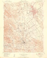
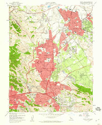
 1959 Concord1961 Print · USGSThe East Bay's mid-century expansion is on full display here as suburban growth reaches into the interior valleys and ridges. Genealogists and local historians can trace legacy sites like Lafayette Cem, the small settlement of Eastport, and the campus of St Marys College.2 unique versions available
 - 1960 Map of San Francisco
 1960 San Francisco1960 Print · USGSThe San Francisco Bay Area at the start of the sixties reveals a landscape of rapid expansion and critical infrastructure. Researchers can trace the development of East Bay communities like Russell City and Mt Eden or locate early rural landmarks like Alpine School.
Showing maps 1-25 of 44
Frequently asked questions
- What are the different types of historical maps available for Sun Terrace?
- What is the oldest map of Sun Terrace?
- Where can I purchase historical maps of Sun Terrace for my home or office?
- Where can I download high-res historical maps of Sun Terrace?
- Are there historical topographic maps available for Sun Terrace?
- Is there historical aerial imagery available for Sun Terrace?
- Where are historical maps of Sun Terrace sourced from?