Old Maps of Pine Glade Summer Home Tract, Mono County
Explore 14 old maps of Pine Glade Summer Home Tract, spanning from 1914 to today. These high-resolution historic maps reveal how streets, neighborhoods, landmarks, and natural features evolved over time — perfect for genealogy, metal detecting, research, and local history exploration.
What you can do with these maps:
- See how Pine Glade Summer Home Tract changed over time: Compare historical maps to modern-day views to trace roads, homesites, rail lines & more.
- View detailed metadata: Each map includes creators, publishers, year, scale, and archive source.
- Overlay maps with satellite & LiDAR: Visualize the past alongside modern tools to explore terrain & human change.
- Trusted historical sources: Maps sourced from the USGS, Library of Congress, and other archives.
- Access maps your way: View online, download high-res files, or order prints for personal or research use.
Start exploring old maps of Pine Glade Summer Home Tract to uncover forgotten places, hidden landmarks, and the deep history beneath your feet.
Pine Glade Summer Home Tract, Mono County maps
(14)- 1914 Map of Mt. Morrison
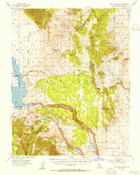
 1914 Mt. Morrison1914 Print · USGSThe High Sierra and Mono Basin are seen here in the early twentieth century, showing a network of remote ranches and early timber camps. Researchers can trace historic sites like Mono Mills, the remote Dutch Petes Ranch, and the Casa Diablo Mine.8 unique versions available
 - 1947 Map of Mariposa, 1948 Print
 1947 Mariposa1948 Print · USGSThe High Sierra and Owens Valley transition is captured here in the late 1940s, just as the region’s hydroelectric and tourism infrastructure was maturing. Genealogists and historians can trace old ranger stations, the Casa Diablo Mine, and rail stops along the Southern Pacific like Benton Station and Zurich.2 unique versions available
 - 1948 Map of Mariposa, 1951 Print
 1948 Mariposa1951 Print · USGSThe High Sierra and Mariposa foothills are shown here in the late 1940s as the post-war tourism and water infrastructure expanded. Genealogists and historians can locate vanished waypoints like Mormon Bar, the Glacier Point Hotel, and the granite quarries of Knowles.
 - 1953 Map of Casa Diablo Mtn, 1955 Print
 1953 Casa Diablo Mtn1955 Print · USGSThe High Sierra and Benton Range meet in the early 1950s, showing a landscape defined by Owens River water and hard-rock mining. Trace the historic mining district through the Casa Diablo Mine, Kings Mill, and the community at Toms Place.4 unique versions available
 - 1957 Map of Mariposa, 1966 Print
 1957 Mariposa1966 Print · USGSThe High Sierra and Owens Valley appear in the mid-fifties, showing the intersection of conservation, hydroelectric power, and mountain industry. Genealogists and researchers can trace local landmarks like Yosemite Cemetery, the remote Kinsley Station, and the Pine Creek Mine.4 unique versions available
 - 1963 Map of Mariposa
 1963 Mariposa1963 Print · USGSThe High Sierra and Owens Valley meet in the early sixties, showing a landscape defined by gold-rush history and massive post-war water projects. Genealogists and researchers can trace old mining routes near Mariposa, locate the Glacier Point Hotel, and find small settlements like Coarse Gold or Knowles Junction.
 - 1984 Map of Toms Place
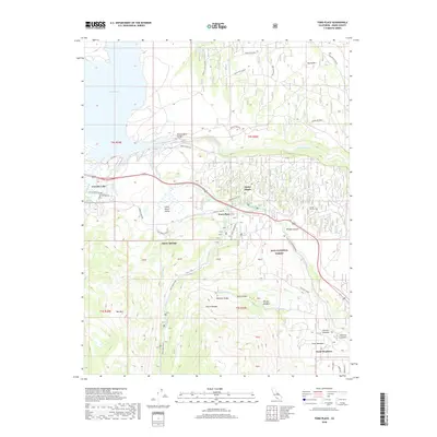
 1984 Toms Place1984 Print · USGSEastern Sierra Nevada settlement and recreation are captured here in the mid-1980s as the high-country gateways developed. Researchers can trace land use through Toms Place, the Long Valley Dam, and backcountry sites like Swall Meadow.
 - 1988 Map of Benton Range
 1988 Benton Range1988 Print · USGSThe high desert and alpine peaks of the California-Nevada border come alive in this late-century survey of the Benton Range. Researchers can trace the heritage of remote outposts like Benton and Montgomery City alongside historic workings like the Black Warrior Mine.2 unique versions available
 - 1990 Map of Toms Place
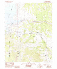
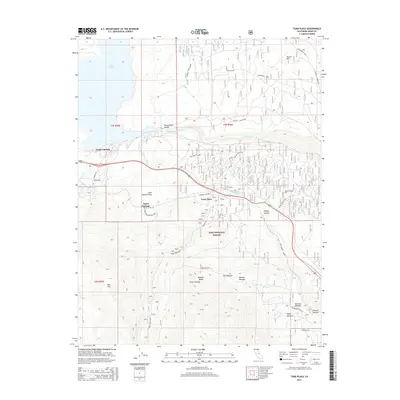
 1990 Toms Place1990 Print · USGSHigh Sierra recreation and water management intersect in the 1990s as Crowley Lake meets the Owens River Gorge. Explore old mountain settlements like Toms Place and Swall Meadow or locate backcountry sites like Big Meadow Campground.
 - 1994 Map of Toms Place, 1997 Print
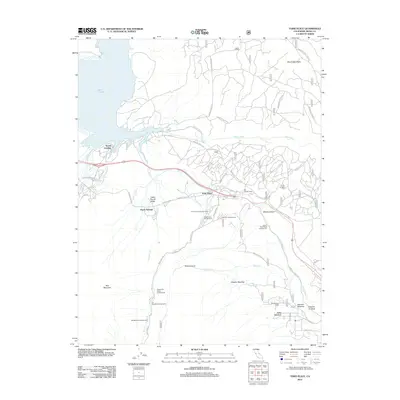
 1994 Toms Place1997 Print · USGSThe Eastern Sierra near Mono County is captured here in the mid-nineties, showing the intersection of water infrastructure and wilderness. Genealogists and local historians can trace developments at Toms Place or locate family sites at Sky Meadow Ranch and Swall Meadow.
 - 2012 Map of Toms Place, 2012 Print
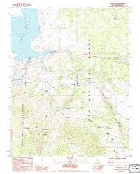
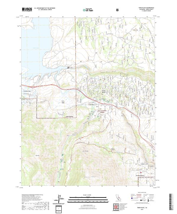
 2012 Toms Place2012 Print · USGSCovers Pine Glade Summer Home Tract, including Crowley Lake, Swall Meadows, and other nearby areas
 - 2015 Map of Toms Place, 2015 Print
 2015 Toms Place2015 Print · USGSCovers Pine Glade Summer Home Tract, including Crowley Lake, Swall Meadows, and other nearby areas
 - 2018 Map of Toms Place, 2018 Print
 2018 Toms Place2018 Print · USGSCovers Pine Glade Summer Home Tract, including Crowley Lake, Swall Meadows, and other nearby areas
 - 2021 Map of Toms Place, 2021 Print
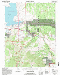
 2021 Toms Place2021 Print · USGSThe Eastern Sierra landscape near Toms Place and Crowley Lake is mapped here in the early twenty-first century. Genealogists and hikers can trace the Old Sherwin Grade and locate old mountain meadows like Witcher Meadow and Swall Meadow.
End of results
Showing maps 1-14 of 14
Frequently asked questions
- What are the different types of historical maps available for Pine Glade Summer Home Tract?
- What is the oldest map of Pine Glade Summer Home Tract?
- Where can I purchase historical maps of Pine Glade Summer Home Tract for my home or office?
- Where can I download high-res historical maps of Pine Glade Summer Home Tract?
- Are there historical topographic maps available for Pine Glade Summer Home Tract?
- Is there historical aerial imagery available for Pine Glade Summer Home Tract?
- Where are historical maps of Pine Glade Summer Home Tract sourced from?