Old Maps of Litchfield, Connecticut
Explore 60 old maps of Litchfield, spanning from 1892 to today. These high-resolution historic maps reveal how streets, neighborhoods, landmarks, and natural features evolved over time — perfect for genealogy, metal detecting, research, and local history exploration.
What you can do with these maps:
- See how Litchfield changed over time: Compare historical maps to modern-day views to trace roads, homesites, rail lines & more.
- View detailed metadata: Each map includes creators, publishers, year, scale, and archive source.
- Overlay maps with satellite & LiDAR: Visualize the past alongside modern tools to explore terrain & human change.
- Trusted historical sources: Maps sourced from the USGS, Library of Congress, and other archives.
- Access maps your way: View online, download high-res files, or order prints for personal or research use.
Start exploring old maps of Litchfield to uncover forgotten places, hidden landmarks, and the deep history beneath your feet.
Litchfield, CT maps
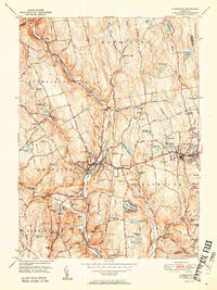
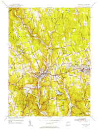
(60)- 1892 Map of Winsted
 1892 Winsted1892 Print · USGSLitchfield County's industrial valleys and upland villages are captured here in the late nineteenth century, during the peak of the region's railroad era. Researchers can trace historic property locations and rail spurs in Winsted, Torrington, and along the shores of Highland Lake.10 unique versions available
 - 1892 Map of Cornwall
 1892 Cornwall1892 Print · USGSLitchfield County in the 1890s reveals a landscape of river-powered industry and rail-connected villages. Researchers can trace ancestral roots and old transport routes through Ore Hill, Lime Rock, and the stops along the Housatonic Railroad.
 - 1892 Map of New Milford
 1892 New Milford1892 Print · USGSLitchfield County in the late nineteenth century is defined by the steep valleys of the Housatonic and Shepaug rivers. Genealogists and researchers can trace the rail-and-river economy through landmarks like Housatonic Railroad, Boardmans Bridge, and Washington Green.
 - 1893 Map of Waterbury
 1893 Waterbury1893 Print · USGSWestern Connecticut in the late nineteenth century was defined by the industrial pulse of the Naugatuck valley and the quiet hills to its west. Genealogists and historians can trace the early rail alignments of the Northern R. R. and locate family landmarks like White Deer Rocks or the village of Hotchkissville.2 unique versions available
 - 1893 Map of New Milford
 1893 New Milford1893 Print · USGSLitchfield County's river valleys and hills are captured here in the late nineteenth century, showing the region's development before modern expansion. Genealogists can trace the rail-and-river network through historic depots like Merwinsville and old village centers including Washington Green and Bridgewater.2 unique versions available
 - 1893 Map of Cornwall
 1893 Cornwall1893 Print · USGSLitchfield County's iron-mining and rail-corridor history comes into focus in the 1890s as the Housatonic Railroad follows the river valley. Genealogists and historians can trace old property lines and rural centers like Ore Hill, Lime Rock, and Amenia Union.3 unique versions available
 - 1903 Map of Cornwall
 1903 Cornwall1903 Print · USGSNorthwestern Connecticut at the dawn of the twentieth century shows a landscape of iron-mining hamlets and river-valley rail lines. Genealogists and historians can trace the foundations of Ore Hill, the streets of Salisbury, and the path of the Central New England RR.9 unique versions available
 - 1904 Map of New Milford
 1904 New Milford1904 Print · USGSLitchfield County at the close of the nineteenth century is defined by the industrial valleys of the Housatonic River and the rural reaches of Washington. Researchers can trace the era's infrastructure through landmarks like Kent Furnace, the Berkshire Division rail line, and the village at Roxbury Station.8 unique versions available
 - 1904 Map of Waterbury
 1904 Waterbury1904 Print · USGSThe Naugatuck River valley's industrial peak and the surrounding Litchfield Hills are captured here at the start of the twentieth century. Researchers can trace the early rail networks of the Naugatuck Division and find old local landmarks like Reynolds Bridge, Quassapaug Pond, and Hotchkissville.8 unique versions available
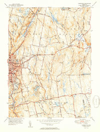
 - 1904 Map of Litchfield
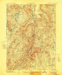
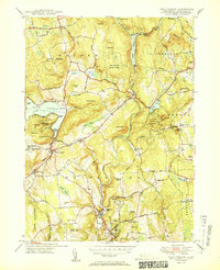
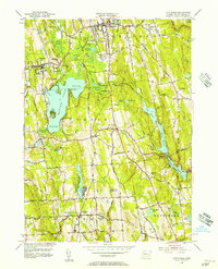
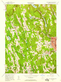
 1904 Litchfield1904 Print · USGSThe Litchfield Hills at the turn of the century are shown here as a landscape of iron heritage and river-powered industry. Genealogists and historians can locate old industrial sites like Kent Furnace, ancestral homes near Sharon Valley, and early rail stops at Limerock Sta..3 unique versions available
 - 1947 Map of Hartford, 1955 Print
 1947 Hartford1955 Print · USGSSouthern New England and the Hudson Valley are shown in detail during the post-war expansion era. Genealogists and researchers can trace local landmarks from the State Capitol and Yale University to the Stratford Lighthouse and Woodlawn Cem.2 unique versions available
 - 1948 Map of Hartford
 1948 Hartford1948 Print · USGSSouthern New England is captured here in the late 1940s, showcasing a landscape of thriving industrial cities and developing parkways. Genealogists and historians can trace the rail networks of the New York New Haven and Hartford RR or locate coastal defense sites like Fort Terry and Camp Shanks.2 unique versions available
 - 1948 Map of Torrington, 1955 Print
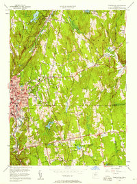
 1948 Torrington1955 Print · USGSLitchfield County's industrial and rural heart comes alive in this post-war survey of Torrington and its surrounding hill towns. Genealogists and historians can trace family locations near Hillside Cemetery, the Torringford Ch, and the outlying settlement of Bakersville.
 - 1950 Map of Cornwall
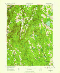
 1950 Cornwall1950 Print · USGSLitchfield County's upland terrain is captured here in the mid-twentieth century, centered on the historic villages and forested ridges of Cornwall and Goshen. Researchers can locate numerous family burial grounds like Allen Cem and Cornwall Cem, or trace the path of the Appalachian Trail as it crossed Dudleytown Hill.2 unique versions available
 - 1950 Map of New Preston
 1950 New Preston1950 Print · USGSLitchfield County's upland terrain is captured here at mid-century, featuring the established summer colonies and rural hamlets of the southern Berkshires. Researchers can trace historic property lines near Lake Waramaug or locate local landmarks like the Gunnery Sch and Washington Depot.2 unique versions available
 - 1950 Map of Litchfield
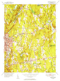
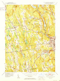
 1950 Litchfield1950 Print · USGSLitchfield County's lake-and-reservoir landscape is meticulously captured here mid-century, showing the early infrastructure of the southern Berkshires. Trace the shores of Bantam Lake or locate ancestral sites like Old Bethlehem Cem and the village of East Morris.2 unique versions available
 - 1951 Map of Thomaston
 1951 Thomaston1951 Print · USGSMid-century Litchfield County unfolds along the industrial Naugatuck valley and the rising Litchfield Hills during a period of steady growth. Genealogists and historians can locate numerous family burial grounds including Allentown Cem, trace the New York New Haven and Hartford rail lines, or find the Leatherman Cave.2 unique versions available
 - 1951 Map of Torrington
 1951 Torrington1951 Print · USGSTorrington and Harwinton appear at a mid-century peak of industrial activity and rural transition. Genealogists can trace family names at Hillside Cemetery, locate the old Harwinton Sch, or find local landmarks like Turtle Rock.2 unique versions available
 - 1951 Map of West Torrington
 1951 West Torrington1951 Print · USGSLitchfield County in the early fifties shows a landscape of historic hilltop farms and growing educational institutions. Trace local history at the John Browns Birthplace (Ruins) or find family roots in the Old Middle Street Cem and Newfield Cem.2 unique versions available
 - 1955 Map of New Preston, 1956 Print
 1955 New Preston1956 Print · USGSLitchfield County's uplands and valleys are meticulously detailed in the mid-1950s, centered on the historic villages of Washington Depot and New Preston. Local historians can trace institutional landmarks like Rumsey Hall Sch and ancestral sites such as Judea Cem along the Shepaug River.7 unique versions available
 - 1956 Map of Litchfield, 1957 Print
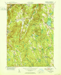
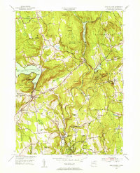
 1956 Litchfield1957 Print · USGSMid-century Litchfield County is captured here during a period of steady residential and institutional growth. Researchers can trace the development of lakeside communities near Lakeside or locate ancestral sites like West Cem and Wamogo High Sch.7 unique versions available
 - 1956 Map of Thomaston, 1957 Print
 1956 Thomaston1957 Print · USGSLitchfield County's industrial river valleys and wooded uplands are captured here in the mid-fifties, showing the intersection of rail, water, and town life. Trace the path of the New York New Haven and Hartford railroad through Thomaston or locate old community landmarks like Eagle Rock Ch and the Terryville Tunnel.7 unique versions available
 - 1956 Map of Cornwall, 1958 Print
 1956 Cornwall1958 Print · USGSMid-century Litchfield County is captured here during a time when small hamlets and state forests defined the Housatonic Valley. Genealogists and hikers can trace family-named sites like Kellogg Corners and the original path of the Appalachian Trail near Dudleytown Hill.5 unique versions available
 - 1956 Map of Torrington, 1958 Print
 1956 Torrington1958 Print · USGSTorrington and Harwinton appear here in the mid-fifties, showing a landscape defined by industrial river corridors and expanding residential hills. Genealogists can locate family sites at Hillside Cemetery, Sons of Jacob Cem, or the old Wolcott Sch.5 unique versions available
 - 1956 Map of West Torrington, 1958 Print
 1956 West Torrington1958 Print · USGSThe Litchfield Hills in the mid-fifties show a unique mix of industrial river valleys and remote upland institutions. Genealogists can trace family plots at Old Middle Street Cem and explore landmark ruins like John Browns Birthplace.5 unique versions available
Showing maps 1-25 of 60
Top cities near Litchfield
- Waterbury historical maps
- Bristol historical maps
- Torrington historical maps
- Naugatuck historical maps
- Cheshire historical maps
- Watertown historical maps
See more
Top neighborhoods of Litchfield
- Bantam historical maps
- Grappaville historical maps
- Northfield historical maps
- Dempsey Landing historical maps
- East Litchfield historical maps
- Milton historical maps
See more
Frequently asked questions
- What are the different types of historical maps available for Litchfield?
- What is the oldest map of Litchfield?
- Where can I purchase historical maps of Litchfield for my home or office?
- Where can I download high-res historical maps of Litchfield?
- Are there historical topographic maps available for Litchfield?
- Is there historical aerial imagery available for Litchfield?
- Where are historical maps of Litchfield sourced from?