Old Maps of Kapaeloa, Honolulu County
Explore 12 old maps of Kapaeloa, spanning from 1952 to today. These high-resolution historic maps reveal how streets, neighborhoods, landmarks, and natural features evolved over time — perfect for genealogy, metal detecting, research, and local history exploration.
What you can do with these maps:
- See how Kapaeloa changed over time: Compare historical maps to modern-day views to trace roads, homesites, rail lines & more.
- View detailed metadata: Each map includes creators, publishers, year, scale, and archive source.
- Overlay maps with satellite & LiDAR: Visualize the past alongside modern tools to explore terrain & human change.
- Trusted historical sources: Maps sourced from the USGS, Library of Congress, and other archives.
- Access maps your way: View online, download high-res files, or order prints for personal or research use.
Start exploring old maps of Kapaeloa to uncover forgotten places, hidden landmarks, and the deep history beneath your feet.
Kapaeloa, Honolulu County maps
(12)- 1952 Map of Waimea, 1954 Print
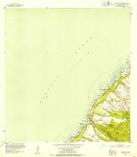 1952 Waimea1954 Print · USGSOahu's North Shore in the early fifties shows the early residential framing of Sunset Beach and the rugged forest reserves of the interior. Trace historic sites like Puu o Mahuka Heiau and follow the route of Kamehameha Highway past Waimea Bay.2 unique versions available
 - 1954 Map of Oahu
 1954 Oahu1954 Print · USGSMid-century Oahu is caught between its plantation roots and its growing role as a Pacific military hub. Trace the OR and L Co rail lines and explore the 1950s footprints of Pearl Harbor, Libbyville, and Waipahu.
 - 1961 Map of Oahu
 1961 Oahu1961 Print · USGSOahu's strategic landscape is captured here during the early statehood era, showing the balance between burgeoning urban centers and massive military installations. Trace the path of the Oahu Railway and Land Co or locate historical sites like Schofield Barracks and Punchbowl Hill.
 - 1965 Map of Oahu
 1965 Oahu1965 Print · USGSOahu in the mid-sixties reveals a landscape defined by significant military installations and growing coastal communities. Researchers can trace the infrastructure of Pearl Harbor, Schofield Barracks, and landmarks like Diamond Head.2 unique versions available
 - 1966 Map of Waimea, 1967 Print
 1966 Waimea1967 Print · USGSThe North Shore of Oahu in the mid-1960s reveals a landscape of ancient sacred sites and burgeoning coastal settlements. Researchers can trace the heritage of Puu O Mahuka Heiau, the expanse of Kalou Marsh, and the grounds of Camp Pupukea.
 - 1970 Map of Oahu, 1973 Print
 1970 Oahu1973 Print · USGSOahu was entering a new era of suburban and military expansion in the early seventies. Trace the growth of Mililani Town and Pearl City, or locate historic sites like Schofield Barracks and Diamond Head State Monument.2 unique versions available
 - 1977 Map of Waimea, 1984 Print
 1977 Waimea1984 Print · USGSThe North Shore of Oahu is captured in detail during the late seventies, showing the transition of this famous coastline before modern development. Researchers can trace the layout of Waimea and the beachfront at Kawailoa Beach alongside the waters of Waimea Bay.
 - 1983 Map of Waimea
 1983 Waimea1983 Print · USGSThe North Shore of Oahu in the early eighties shows a landscape of world-famous beaches and deep cultural heritage. Trace the coastline from Sunset Beach down to Waimea Bay, locating ancient sites like Kupupolo Heiau and the grounds of Waimea Falls.2 unique versions available
 - 1998 Map of Waimea, 2000 Print
 1998 Waimea2000 Print · USGSThe North Shore of Oahu comes into focus in the late nineties, showing the established coastal communities and the preserved uplands. Trace the development of Pupukea Homesteads and find landmarks like Sunset Beach Sch and the Pu'uomahuka State Monument.
 - 2013 Map of Waimea, 2013 Print
 2013 Waimea2013 Print · USGSCovers Kapaeloa, including Waiale‘e, Honolulu County, and other nearby areas
 - 2017 Map of Waimea, 2017 Print
 2017 Waimea2017 Print · USGSCovers Kapaeloa, including Waiale‘e, Honolulu County, and other nearby areas
 - 2024 Map of Waimea, 2024 Print
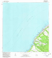
 2024 Waimea2024 Print · USGSThe North Shore of O'ahu is documented here in the mid-2020s, showing the intersection of coastal settlements and the island's steep interior gulches. Researchers can trace the path of the Waimea River to Waimea Falls or explore the residential layouts of Sunset Beach and Pupukea.
End of results
Showing maps 1-12 of 12
Frequently asked questions
- What are the different types of historical maps available for Kapaeloa?
- What is the oldest map of Kapaeloa?
- Where can I purchase historical maps of Kapaeloa for my home or office?
- Where can I download high-res historical maps of Kapaeloa?
- Are there historical topographic maps available for Kapaeloa?
- Is there historical aerial imagery available for Kapaeloa?
- Where are historical maps of Kapaeloa sourced from?