Old Maps of Dwight, Belchertown
Explore 21 old maps of Dwight, spanning from 1887 to today. These high-resolution historic maps reveal how streets, neighborhoods, landmarks, and natural features evolved over time — perfect for genealogy, metal detecting, research, and local history exploration.
What you can do with these maps:
- See how Dwight changed over time: Compare historical maps to modern-day views to trace roads, homesites, rail lines & more.
- View detailed metadata: Each map includes creators, publishers, year, scale, and archive source.
- Overlay maps with satellite & LiDAR: Visualize the past alongside modern tools to explore terrain & human change.
- Trusted historical sources: Maps sourced from the USGS, Library of Congress, and other archives.
- Access maps your way: View online, download high-res files, or order prints for personal or research use.
Start exploring old maps of Dwight to uncover forgotten places, hidden landmarks, and the deep history beneath your feet.
Dwight, Belchertown maps
(21)- 1887 Map of Belchertown
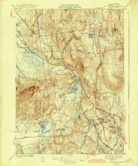
 1887 Belchertown1887 Print · USGSThe Swift River valley is shown here in the late 1880s, before the landscape was transformed. Researchers can trace the original rail lines of the Boston & Albany R. R. and locate the lost streets of Enfield, Greenwich, and Prescott.
 - 1890 Map of Belchertown
 1890 Belchertown1890 Print · USGSThe Swift River valley is seen here in the late nineteenth century, long before the creation of the Quabbin Reservoir. Genealogists and local historians can trace the vanished streets of Enfield, Greenwich, and North Dana, or follow the old Boston & Albany R. R. line.
 - 1893 Map of Belchertown
 1893 Belchertown1893 Print · USGSThe Swift River valley is shown here in the 1890s, years before the landscape was fundamentally altered. Genealogists can trace family homes and rail routes through Enfield, Prescott, North Dana, and the Boston & Albany R R.8 unique versions available
 - 1908 Map of Ware
 1908 Ware1908 Print · USGSCentral Massachusetts at the turn of the century reveals the Swift River Valley decades before the Quabbin Reservoir changed the landscape forever. Trace the lost footprints of Enfield and Dana, or follow the Central Vermont RR through Greenwich Village and Ware.2 unique versions available
 - 1942 Map of Ware
 1942 Ware1942 Print · USGSCentral Massachusetts and the Connecticut border are captured here during the early years of the war, just as the landscape was being reshaped by the Quabbin Reservoir. Researchers can trace rail-era industry and local landmarks like the Lead Mine and the Bald Peak Hospital.
 - 1942 Map of Belchertown
 1942 Belchertown1942 Print · USGSHampshire County at the start of the 1940s reveals a landscape of rural crossroads and growing state institutions. Genealogists and historians can trace family-named landmarks like Cooks Corner and Meads Corner or locate the sprawling State School grounds.
 - 1943 Map of Belchertown
 1943 Belchertown1943 Print · USGSHampshire County at the onset of the 1940s reveals a landscape where rail lines and rural schools defined the community. Genealogists and historians can trace family roots at Dwight Cem or locate institutional landmarks like St Hyacinths Seminary and the State School.4 unique versions available
 - 1948 Map of Albany, 1951 Print
 1948 Albany1951 Print · USGSThe Hudson and Connecticut River valleys are captured here in the late 1940s, showing the vital rail and water corridors of the Northeast. You can trace the Boston and Maine tracks past Mt Greylock or locate early settlements like Great Barrington and Bennington.
 - 1949 Map of Belchertown, 1958 Print
 1949 Belchertown1958 Print · USGSHampshire County at the mid-point of the twentieth century remains a landscape of railroad hamlets and mountain trails. Genealogists and historians can trace family burial sites like Rural Cem and Pelham Cem or follow the old Central Vermont rail line through Dwight.2 unique versions available
 - 1956 Map of Albany, 1968 Print
 1956 Albany1968 Print · USGSThe industrial heart of the Northeast is revealed in the mid-1950s, from the Hudson Valley to the Connecticut River. Researchers can trace the legacy of the Quabbin Reservoir, locate Westover Air Force Base, or follow the Rutland RR through the Green Mountains.2 unique versions available
 - 1957 Map of Albany
 1957 Albany1957 Print · USGSThe Tri-State region and Connecticut River Valley are captured here during a period of significant postwar growth and infrastructure expansion. Genealogists and historians can trace the rail-and-river economy through landmarks like the Boston and Maine railroad, Quabbin Reservoir, and Westover Air Force Base.
 - 1959 Map of Albany
 1959 Albany1959 Print · USGSThe Hudson and Connecticut River valleys are captured here during the late fifties, showing the region's dense rail networks and massive water projects. Researchers can trace the New York State Thruway or locate local landmarks like Mt Greylock and the Quabbin Reservoir.
 - 1962 Map of Albany
 1962 Albany1962 Print · USGSThe Hudson and Connecticut River valleys meet the Green Mountains and Berkshires in this mid-century overview of the Northeast. Genealogists and historians can trace the industrial hearts of Albany and Springfield or locate features like Quabbin Reservoir and Westover Air Force Base.
 - 1964 Map of Belchertown, 1966 Print
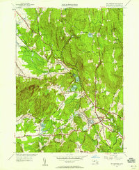
 1964 Belchertown1966 Print · USGSHampshire County in the mid-sixties reveals a landscape of wooded ridges and established institutions before later development. Researchers can trace the Central Vermont rail line and locate landmarks like the Belchertown State School or Munsell Cem.3 unique versions available
 - 1975 Map of Belchertown, 1981 Print
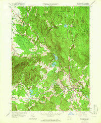
 1975 Belchertown1981 Print · USGSHampshire County land use and crossroads settlements are revealed in this mid-seventies aerial survey of the Massachusetts interior. Genealogists and local historians can trace the development of Belchertown and smaller locales like Dwight and Cooks Corner.
 - 1985 Map of Holyoke, 1986 Print
 1985 Holyoke1986 Print · USGSThe Pioneer Valley and surrounding uplands appear here in the mid-eighties, showing a landscape defined by the Connecticut River and modern highway expansion. Genealogists and historians can trace rail lines like the Central Vermont Railway and locate regional landmarks from Mount Tom State Reservation to the Quabbin Reservoir.2 unique versions available
 - 2012 Map of Belchertown, 2012 Print
 2012 Belchertown2012 Print · USGSCovers Dwight, including Amherst, Belchertown, and other nearby areas
 - 2015 Map of Belchertown, 2015 Print
 2015 Belchertown2015 Print · USGSCovers Dwight, including Amherst, Belchertown, and other nearby areas
 - 2018 Map of Belchertown, 2018 Print
 2018 Belchertown2018 Print · USGSCovers Dwight, including Amherst, Belchertown, and other nearby areas
 - 2021 Map of Belchertown, 2021 Print
 2021 Belchertown2021 Print · USGSCovers Dwight, including Amherst, Belchertown, and other nearby areas
 - 2024 Map of Belchertown, 2024 Print
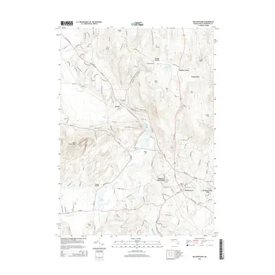
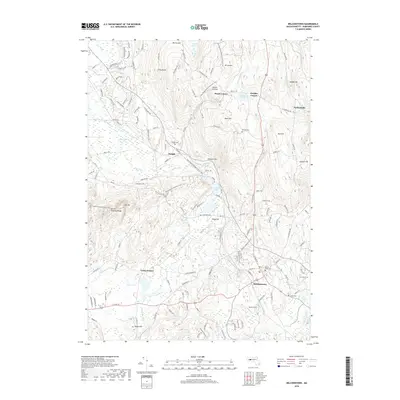
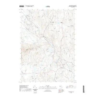
 2024 Belchertown2024 Print · USGSHampshire County in the twenty-first century maintains its rural character across the ridges and valleys of Belchertown. Family historians can trace local roots through Mount Hope Cem, Rural Cem, and the historic settlements of Packardville and Dwight.
End of results
Showing maps 1-21 of 21
Top cities near Dwight
- Springfield historical maps
- Chicopee historical maps
- Holyoke historical maps
- Amherst historical maps
- Northampton historical maps
- Agawam historical maps
See more
Frequently asked questions
- What are the different types of historical maps available for Dwight?
- What is the oldest map of Dwight?
- Where can I purchase historical maps of Dwight for my home or office?
- Where can I download high-res historical maps of Dwight?
- Are there historical topographic maps available for Dwight?
- Is there historical aerial imagery available for Dwight?
- Where are historical maps of Dwight sourced from?