Old Maps of Milwaukee Junction, Detroit
Explore 29 old maps of Milwaukee Junction, spanning from 1905 to today. These high-resolution historic maps reveal how streets, neighborhoods, landmarks, and natural features evolved over time — perfect for genealogy, metal detecting, research, and local history exploration.
What you can do with these maps:
- See how Milwaukee Junction changed over time: Compare historical maps to modern-day views to trace roads, homesites, rail lines & more.
- View detailed metadata: Each map includes creators, publishers, year, scale, and archive source.
- Overlay maps with satellite & LiDAR: Visualize the past alongside modern tools to explore terrain & human change.
- Trusted historical sources: Maps sourced from the USGS, Library of Congress, and other archives.
- Access maps your way: View online, download high-res files, or order prints for personal or research use.
Start exploring old maps of Milwaukee Junction to uncover forgotten places, hidden landmarks, and the deep history beneath your feet.
Milwaukee Junction, Detroit maps
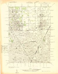
(29)- 1905 Map of Detroit
 1905 Detroit1905 Print · USGSDetroit and its surrounding townships are shown at a pivotal moment of expansion during the early 1900s. Genealogists and historians can trace the development of early suburbs like Highland Park and Royal Oak along major transit arteries like Grand River Ave. and the numerous electric railways.2 unique versions available
 - 1918 Map of Detroit
 1918 Detroit1918 Print · USGSDetroit and its surrounding townships appear at the height of the early industrial era, captured just after the close of the Great War. Local researchers can trace the growth of the Ford Motor Co. empire near Navarre P.O. and explore the historic rail corridors of Hamtramck and Royal Oak.
 - 1924 Map of Detroit
 1924 Detroit1924 Print · USGSDetroit and its industrial satellites thrive during the peak of the automotive era. Genealogists and historians can trace the early factory footprints of Dodge Bros. or locate old neighborhood landmarks like Navarre P. O. and Mt. Olivet Cemetery.
 - 1934 Map of Detroit
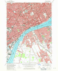
 1934 Detroit1934 Print · USGSThe Detroit riverfront and its rising industrial suburbs are captured here during the peak of the automotive boom. Genealogists and historians can trace the early footprints of the Ford Motor Co and local landmarks like Olivet Cemetery or the State Fair Grounds.
 - 1936 Map of Highland Park
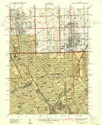
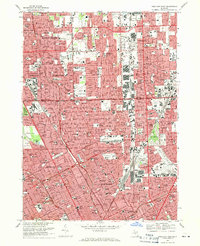
 1936 Highland Park1936 Print · USGSGreater Detroit and the enclaves of Highland Park and Hamtramck are captured here in the mid-1930s as urban growth pushes north. Researchers can pinpoint early neighborhoods, local schools like Henry Ford Sch, and the grounds of the Michigan State Fair.
 - 1937 Map of Detroit
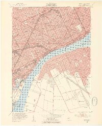
 1937 Detroit1937 Print · USGSDetroit at the peak of its industrial era shows a bustling riverfront and a dense grid of neighborhoods just before the war. Researchers can trace the rail-and-water economy through the Union Depot, Zug Island, and the international Ambassador Bridge.
 - 1940 Map of Highland Park
 1940 Highland Park1940 Print · USGSGreater Detroit was expanding rapidly just before the war, as residential grids replaced the agricultural lands of southern Macomb and Oakland Counties. Genealogists and historians can locate family landmarks like the Michigan State Fair Grounds and St Clements Cem.2 unique versions available
 - 1940 Map of Detroit
 1940 Detroit1940 Print · USGSDetroit and its Canadian neighbors thrive as a unified industrial corridor during the late thirties. Researchers can trace the massive rail-and-river network through the Detroit-Windsor Tunnel, Union Depot, and industrial sites like Zug Island.
 - 1947 Map of Detroit
 1947 Detroit1947 Print · USGSPost-war Detroit and its Ontario neighbors are shown in meticulous detail during the city's industrial peak. Researchers can trace the mid-century urban fabric through dozens of local landmarks like Briggs Stadium, the Ambassador Bridge, and Wayne University.
 - 1952 Map of Detroit, 1954 Print
 1952 Detroit1954 Print · USGSThe industrial border between Michigan and Ontario is captured here at the mid-century peak of the automotive era. Researchers can trace the massive rail networks of the New York Central, locate neighborhood landmarks like Briggs Stadium, or find family sites near Mt Elliot Cemetery.2 unique versions available
 - 1952 Map of Highland Park, 1954 Print
 1952 Highland Park1954 Print · USGSMid-century Detroit and its northern enclave cities show a bustling urban landscape at the height of the industrial era. Trace neighborhood roots across Highland Park and Hamtramck using landmarks like Evergreen Cemetery and the City Airport.2 unique versions available
 - 1954 Map of Detroit
 1954 Detroit1954 Print · USGSThe Detroit metro and its Ontario neighbors are shown at the height of the mid-century industrial era, just as the suburbs were rapidly expanding. Researchers can trace the massive rail networks of the Wabash Railroad or locate landmarks like Grosse Ile and Selfridge Air Force Base.
 - 1954 Map of Detroit
 1954 Detroit1954 Print · USGSDetroit and Windsor sit at their industrial peak in the early fifties, linked by the Ambassador Bridge and busy rail tunnels. Trace neighborhood roots across a dense grid of parish schools, the sprawling Wayne University campus, and landmarks like Briggs Stadium.2 unique versions available
 - 1961 Map of Detroit, 1973 Print
 1961 Detroit1973 Print · USGSThe international border between Michigan and Ontario was a bustling industrial corridor in the early sixties. Researchers can trace the transit networks and riverfront infrastructure connecting Detroit to Windsor via the Detroit-Windsor Tunnel and major air hubs like Willow Run Airport.2 unique versions available
 - 1965 Map of Detroit
 1965 Detroit1965 Print · USGSThe industrial corridor between Michigan and Ontario is captured here at mid-century, showing the dense rail and river networks of the Great Lakes. Local historians can trace the paths of the Grand Trunk Western RR and locate key landmarks like Selfridge Air Force Base and Grosse Ile.
 - 1968 Map of Detroit, 1971 Print
 1968 Detroit1971 Print · USGSThe Detroit and Windsor riverfronts meet in this late-sixties survey of the international border. Genealogists and historians can trace urban landmarks like Elmwood Cemetery, the U S Mil Res, and the storied grounds of Tiger Stadium.4 unique versions available
 - 1968 Map of Highland Park, 1971 Print
 1968 Highland Park1971 Print · USGSThe northern Detroit metropolitan area is shown here in its mid-century maturity, featuring the densely packed street grids of industrial enclaves. Genealogists can trace family neighborhoods near Mt Olivet Cem, St Florian High Sch, or along the Grand Trunk Western RR.4 unique versions available
 - 1985 Map of Detroit
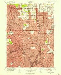
 1985 Detroit1985 Print · USGSSoutheast Michigan in the mid-eighties shows a landscape defined by industrial power and suburban reach from the Detroit River to the Huron Valley. Researchers can trace the rail lines of the Conrail, explore the grounds of the University of Michigan, and locate numerous sites like Mt Olivet Cem.
 - 1989 Map of Detroit, 1991 Print
 1989 Detroit1991 Print · USGSSoutheast Michigan and across the river into Ontario reached a point of peak metropolitan density at the end of the 1980s. Local researchers can trace the footprint of the University of Michigan campus, the industrial waterfronts of Wyandotte, and the extensive grounds of Glen Eden Cem.
 - 2011 Map of Highland Park, 2011 Print
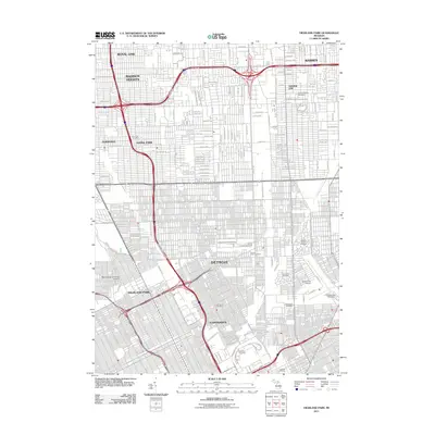 2011 Highland Park2011 Print · USGSCovers Milwaukee Junction, including Detroit, Warren, and other nearby areas
 - 2011 Map of Detroit, 2011 Print
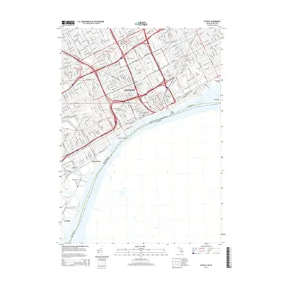
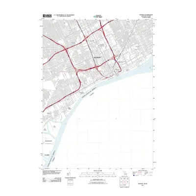 2011 Detroit2011 Print · USGSCovers Milwaukee Junction, including Detroit, Windsor, and other nearby areas
 - 2014 Map of Detroit, 2014 Print
 2014 Detroit2014 Print · USGSCovers Milwaukee Junction, including Detroit, Windsor, and other nearby areas
 - 2014 Map of Highland Park, 2014 Print
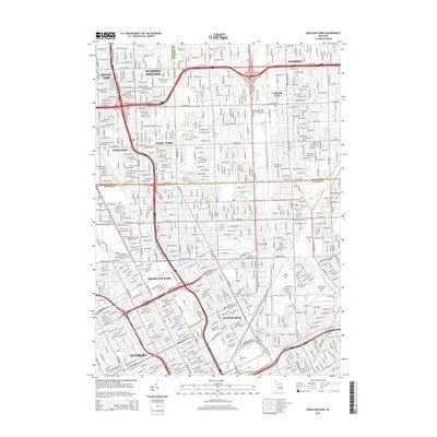 2014 Highland Park2014 Print · USGSCovers Milwaukee Junction, including Detroit, Warren, and other nearby areas
 - 2017 Map of Detroit, 2017 Print
 2017 Detroit2017 Print · USGSCovers Milwaukee Junction, including Detroit, Windsor, and other nearby areas
 - 2017 Map of Highland Park, 2017 Print
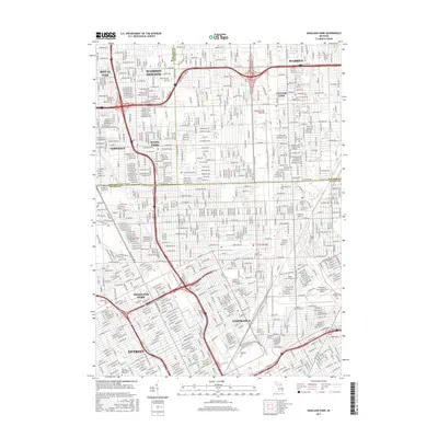 2017 Highland Park2017 Print · USGSCovers Milwaukee Junction, including Detroit, Warren, and other nearby areas
Showing maps 1-25 of 29
Frequently asked questions
- What are the different types of historical maps available for Milwaukee Junction?
- What is the oldest map of Milwaukee Junction?
- Where can I purchase historical maps of Milwaukee Junction for my home or office?
- Where can I download high-res historical maps of Milwaukee Junction?
- Are there historical topographic maps available for Milwaukee Junction?
- Is there historical aerial imagery available for Milwaukee Junction?
- Where are historical maps of Milwaukee Junction sourced from?