Old Maps of Latham, Colonie
Explore 61 old maps of Latham, spanning from 1893 to today. These high-resolution historic maps reveal how streets, neighborhoods, landmarks, and natural features evolved over time — perfect for genealogy, metal detecting, research, and local history exploration.
What you can do with these maps:
- See how Latham changed over time: Compare historical maps to modern-day views to trace roads, homesites, rail lines & more.
- View detailed metadata: Each map includes creators, publishers, year, scale, and archive source.
- Overlay maps with satellite & LiDAR: Visualize the past alongside modern tools to explore terrain & human change.
- Trusted historical sources: Maps sourced from the USGS, Library of Congress, and other archives.
- Access maps your way: View online, download high-res files, or order prints for personal or research use.
Start exploring old maps of Latham to uncover forgotten places, hidden landmarks, and the deep history beneath your feet.
Latham, Colonie maps
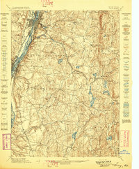
(61)- 1893 Map of Cohoes
 1893 Cohoes1893 Print · USGSThe upper Hudson Valley and its industrial corridor come alive in the 1890s, from the streets of Cohoes to the Bemis Heights Battle Ground. Trace the original paths of the Erie Canal and Champlain Canal through Waterford and Mechanicsville.
 - 1893 Map of Troy
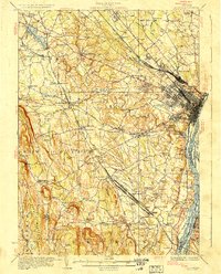
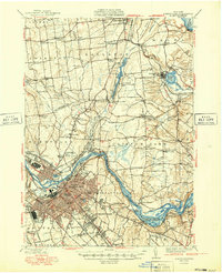
 1893 Troy1893 Print · USGSThe Hudson River valley at the end of the nineteenth century was a bustling hub of commerce where the Erie Canal met the Troy waterfront. Researchers can trace the early rail networks of the Boston and Albany Railroad or locate vanished sites like Schodack Depot and the industrial hamlet of Glass House.
 - 1893 Map of Schenectady
 1893 Schenectady1893 Print · USGSSchenectady and its surrounding Saratoga County townships are captured here in the 1890s, a period when canal traffic and steam rail dominated the Mohawk Valley. Genealogists can trace family lines through villages like Niskayuna and Rexford Flats or locate historic crossings like Vischer Ferry.
 - 1893 Map of Albany
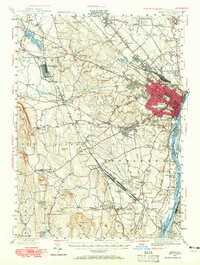
 1893 Albany1893 Print · USGSThe Hudson River valley at the close of the nineteenth century reveals a complex landscape of island commerce and growing rail hubs. Genealogists and historians can trace defunct railroad stops and family-named hamlets like French Mills, Meadowdale, and The Abbey.2 unique versions available
 - 1895 Map of Troy
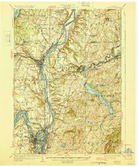
 1895 Troy1895 Print · USGSThe Hudson River valley at the close of the nineteenth century was a bustling nexus of river, rail, and canal traffic. Genealogists and historians can trace family-named hills and early hamlets from Troy to the lakes of Sand Lake, including Glass House and Sliter.
 - 1895 Map of Cohoes
 1895 Cohoes1895 Print · USGSThe Hudson and Mohawk river valleys at the end of the nineteenth century reveal a landscape shaped by canal trade and burgeoning rail lines. Genealogists and local historians can trace the early layouts of Cohoes, Mechanicville, and the historic Battle Ground at Bemis Heights.
 - 1895 Map of Albany
 1895 Albany1895 Print · USGSThe Hudson River valley and the rising Helderberg escarpment are captured here in the 1890s, revealing a landscape defined by steam-era railroads and river islands. Genealogists can trace family homesteads near Shakers, Voorheesville, and the many hamlets of Bethlehem.
 - 1895 Map of Schenectady
 1895 Schenectady1895 Print · USGSSchenectady and its surrounding river towns thrive in the 1890s as the railroad and canal networks reach their peak. Genealogists and historians can trace old homesteads near Vischer Ferry, explore the rail lines of the Fitchburg Railroad, or locate early structures in Rexford Flats and Scotia.
 - 1898 Map of Schenectady
 1898 Schenectady1898 Print · USGSSchenectady and the Mohawk Valley are shown in the 1890s, when the river and rail lines drove a booming industrial economy. Local historians can trace the original path of the Erie Canal and locate historic crossings like Vischer Ferry and Rexford Flats.8 unique versions available
 - 1898 Map of Albany
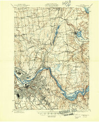
 1898 Albany1898 Print · USGSThe capital region in the late nineteenth century is defined by its massive rail yards and the busy Hudson riverfront. Genealogists can trace family names at Town House Corner or locate vanished landmarks like The Abbey (Gleason) and the community at Shakers.8 unique versions available
 - 1898 Map of Cohoes
 1898 Cohoes1898 Print · USGSUpper Hudson Valley industry and transport are captured here at the end of the nineteenth century, from the confluence of the Mohawk to the hills of Pittstown. Trace the historic path of the Champlain Canal and the storied Battle Ground near Stillwater.8 unique versions available
 - 1898 Map of Troy
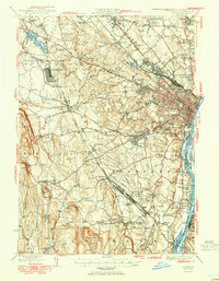
 1898 Troy1898 Print · USGSThe Hudson River valley at the turn of the century shows a bustling corridor of industry and rail before modern expansion transformed the capital region. Researchers can trace historic riverfront districts like Greenbush and Bath or locate vanished rail stops such as Schodack Depot and the Erie Canal route.8 unique versions available
 - 1925 Map of Troy
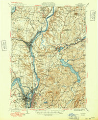
 1925 Troy1925 Print · USGSRensselaer County at the mid-twenties shows a landscape of established mill towns and developing lakefront retreats. Genealogists can trace family roots through numerous sites like St Josephs Cemetery, Teller Mill, and early schoolhouses from Albia to Hoags Corners.
 - 1927 Map of Albany
 1927 Albany1927 Print · USGSThe Albany riverfront and the Helderberg escarpment define this mid-1920s portrait of New York's capital region. Genealogists can trace a dense network of country schoolhouses and old settlements like Feura Bush, Loudonville, and the Bethlehem Church.5 unique versions available
 - 1928 Map of Troy
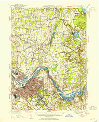
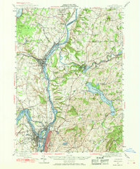
 1928 Troy1928 Print · USGSThe Hudson River valley at the height of its industrial era features the dense centers of Troy and Watervliet. Researchers can trace old neighborhoods near Rensselaer Polytechnic Institute or locate family plots in St Agnes Cemetery and St Marys Cemetery.5 unique versions available
 - 1929 Map of Cohoes
 1929 Cohoes1929 Print · USGSThe industrial and revolutionary history of the Hudson Valley is clear in this late twenties survey of the river's confluence. Researchers can trace early rail stops at Stillwater Center Sta, explore the Saratoga Battlefield, or locate rural schoolhouses from School No 4 to School No 13.4 unique versions available
 - 1930 Map of Schenectady
 1930 Schenectady1930 Print · USGSThe Mohawk Valley and southern Saratoga County are caught in a moment of transition in the late twenties, balancing industrial river life with rural farmsteads. Genealogists and historians can trace the Erie Canal (Abandoned) path and locate old family landmarks like Harmony Corners or Vischer Ferry.5 unique versions available
 - 1947 Map of Schenectady, 1954 Print
 1947 Schenectady1954 Print · USGSThe Schenectady region in the late 1940s reveals a powerful industrial hub at the intersection of rail, river, and canal. Researchers can trace the legacy of the Erie Canal, find rural district schools, and locate old family crossroads like Groom Corners and Vischer Ferry.2 unique versions available
 - 1947 Map of Albany, 1965 Print
 1947 Albany1965 Print · USGSThe Albany capital region is captured here shortly after the war, showing the city's transition into suburban Delmar and Loudonville. Researchers can trace the massive Voorheesville Army Sub Depot, the Albany Airport, and old landmarks like Graceland Cemetery.
 - 1947 Map of Cohoes, 1968 Print
 1947 Cohoes1968 Print · USGSThe Hudson and Mohawk river valleys converge here in the mid-1940s, revealing a dense network of canals and early industrial railroads. Researchers can trace the Champlain Canal (Abandoned), find old rural schoolhouses, and locate landmarks like the Fire Lookout Tower and Cohoes Falls.
 - 1948 Map of Schenectady
 1948 Schenectady1948 Print · USGSSchenectady and its surrounding Saratoga County townships are captured here in the late 1940s as industrial rail hubs and rural hamlets met. Genealogists and local historians can trace family-named sites like Groom Corners, the Erie Canal (Abandoned), and Vischer Ferry.
 - 1948 Map of Albany, 1951 Print
 1948 Albany1951 Print · USGSThe Hudson and Connecticut River valleys are captured here in the late 1940s, showing the vital rail and water corridors of the Northeast. You can trace the Boston and Maine tracks past Mt Greylock or locate early settlements like Great Barrington and Bennington.
 - 1949 Map of Cohoes
 1949 Cohoes1949 Print · USGSThe Hudson and Mohawk river valleys meet in the late 1940s at the industrial nexus of Cohoes and Troy. Local historians can trace early transport routes along the Champlain Canal, find family names near Bemis Heights, or locate old landmarks like the Fire Lookout Tower.2 unique versions available
 - 1949 Map of Schenectady
 1949 Schenectady1949 Print · USGSSchenectady and its surrounding Saratoga County townships are captured here in the late 1940s as the riverfront industry and rail networks remained in full swing. Genealogists can locate family landmarks in old hamlets like Maltaville and Groom Corners or trace the historic Erie Canal (Abandoned).
 - 1950 Map of Albany
 1950 Albany1950 Print · USGSMid-century Albany and its burgeoning suburbs are captured here at a peak of rail and river commerce. Genealogy and local history researchers can trace the New York Central lines to the Selkirk Yards or find family landmarks like Keefers Corners and Bethlehem Church.
Showing maps 1-25 of 61
Top cities near Latham
- Albany historical maps
- Colonie historical maps
- Schenectady historical maps
- Troy historical maps
- Clifton Park historical maps
- Guilderland historical maps
See more
Top neighborhoods of Latham
Frequently asked questions
- What are the different types of historical maps available for Latham?
- What is the oldest map of Latham?
- Where can I purchase historical maps of Latham for my home or office?
- Where can I download high-res historical maps of Latham?
- Are there historical topographic maps available for Latham?
- Is there historical aerial imagery available for Latham?
- Where are historical maps of Latham sourced from?