Old Maps of Waverly, Barton
Explore 28 old maps of Waverly, spanning from 1902 to today. These high-resolution historic maps reveal how streets, neighborhoods, landmarks, and natural features evolved over time — perfect for genealogy, metal detecting, research, and local history exploration.
What you can do with these maps:
- See how Waverly changed over time: Compare historical maps to modern-day views to trace roads, homesites, rail lines & more.
- View detailed metadata: Each map includes creators, publishers, year, scale, and archive source.
- Overlay maps with satellite & LiDAR: Visualize the past alongside modern tools to explore terrain & human change.
- Trusted historical sources: Maps sourced from the USGS, Library of Congress, and other archives.
- Access maps your way: View online, download high-res files, or order prints for personal or research use.
Start exploring old maps of Waverly to uncover forgotten places, hidden landmarks, and the deep history beneath your feet.
Waverly, Barton maps
(28)- 1902 Map of Waverly
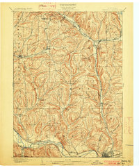 1902 Waverly1902 Print · USGSThe Chemung River valley and the Pennsylvania borderlands come alive in this turn-of-the-century survey of Tioga and Chemung counties. Genealogists and rail historians can trace defunct stations and crossroads like Van Etten Junction, Owens Mills, and the village of Wellsburg.7 unique versions available
 - 1905 Map of Watkins Glen
 1905 Watkins Glen1905 Print · USGSThe Finger Lakes and Southern Tier regions are captured at the start of the century, showing a landscape defined by deep glens and heavy rail. Genealogists and historians can trace the paths of the Northern Central RR through Watkins or locate family sites near Burdett and Horseheads.4 unique versions available
 - 1939 Map of Sayre, 1966 Print
 1939 Sayre1966 Print · USGSBradford County’s river valleys and upland farms are captured here just before the war, when the Lehigh Valley Railroad powered the bustling junction at Sayre. Researchers can trace old family sites at Ayers Crossroads, local landmarks like Luthers Mills, and several rural schools including Harkness Sch.
 - 1942 Map of Sayre
 1942 Sayre1942 Print · USGSThe river confluence at Sayre and Athens stands as a major rail and industrial center in the years before the war. Family historians can trace rural roots through numerous upland landmarks like Harkness Cem, Riggs Ch, and the Doty Hill Sch.2 unique versions available
 - 1948 Map of Sayre
 1948 Sayre1948 Print · USGSThe twin rivers of Bradford County meet in the late 1940s, defining a landscape shaped by the Lehigh Valley railroad and valley agriculture. Genealogists can trace early homesteads and landmarks like Harknessburg Cem, Doty Hill Sch, and Ridgebury Chapel.3 unique versions available
 - 1950 Map of Elmira
 1950 Elmira1950 Print · USGSThe Finger Lakes region thrived in the late 1940s as a hub of industry and transport. Trace family roots and vanished landmarks near Seneca Lake or explore the rail lines of the Erie RR and the sprawling Seneca Ordnance Depot.2 unique versions available
 - 1954 Map of Williamsport
 1954 Williamsport1954 Print · USGSNorth-central Pennsylvania in the mid-fifties is defined by the winding West Branch Susquehanna River and its industrial valley. Local historians can trace the massive Susquehanna Ordnance Depot and the extensive rail networks of the Pennsylvania Railroad.
 - 1954 Map of Waverly, 1956 Print
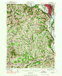
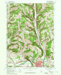
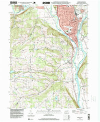
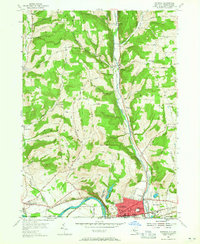 1954 Waverly1956 Print · USGSThe village of Waverly appears here as a bustling rail crossroads during the mid-fifties, situated right at the New York and Pennsylvania state line. You can trace the legacy of early settlements and rural infrastructure through Owens Mill, the Bogart Hill Sch, and the winding tracks of the Lehigh Valley railroad.2 unique versions available
 - 1954 Map of Waverly, 1961 Print
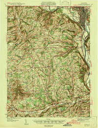
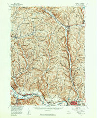 1954 Waverly1961 Print · USGSThe Southern Tier's river valleys and rail networks are caught at a mid-century peak in this survey of Tioga and Chemung counties. Genealogists can trace family names through landmarks like Austin Hill Cem, the Double Mill Sch, and the historical Newtown Battlefield State Park.2 unique versions available
 - 1957 Map of Sayre, 1958 Print
 1957 Sayre1958 Print · USGSThe Susquehanna and Chemung rivers meet in this late 1950s survey of the northern Pennsylvania border. Researchers can trace the industrial footprint of the Lehigh Valley RR, locate the Milan Cem, or explore old river landings like Greenes Landing.4 unique versions available
 - 1958 Map of Elmira
 1958 Elmira1958 Print · USGSThe New York Finger Lakes during the late fifties reveal a complex landscape of glacial geology and industrial growth. Researchers can trace historic transport corridors like the Erie Canal and Erie RR, or locate institutional landmarks like Cornell University.2 unique versions available
 - 1960 Map of Williamsport
 1960 Williamsport1960 Print · USGSNorth-central Pennsylvania in the mid-twentieth century was a vital corridor of rail and river industry stretching from the New York line to the coal regions. Genealogists can trace the rail networks of the Pennsylvania RR and Lehigh Valley RR connecting towns like Williamsport, Towanda, and Lock Haven.
 - 1962 Map of Williamsport, 1966 Print
 1962 Williamsport1966 Print · USGSNorth-central Pennsylvania was a landscape of industrial river hubs and vast state woodlands in the early sixties. Researchers can trace the path of the Pennsylvania Railroad through Williamsport and explore the remote reaches of Bucktail State Park.5 unique versions available
 - 1962 Map of Elmira, 1969 Print
 1962 Elmira1969 Print · USGSThe Finger Lakes region and Southern Tier are captured here during a period of industrial maturity and highway expansion. Researchers can trace the path of the Erie Canal, the footprint of the Seneca Army Depot, and legacy rail lines through Elmira and Ithaca.4 unique versions available
 - 1965 Map of Elmira
 1965 Elmira1965 Print · USGSThe Finger Lakes and Southern Tier regions are captured in the mid-sixties, showcasing a landscape of deep glacial valleys and heavy rail infrastructure. Trace old railroad corridors like the Pennsylvania RR or visit landmarks like Letchworth State Park and the Seneca Army Depot.
 - 1965 Map of Williamsport
 1965 Williamsport1965 Print · USGSNorth-central Pennsylvania in the mid-1960s is defined by the industrial river towns and vast timberlands of the Allegheny Plateau. Researchers can trace historic rail lines like the Erie Lackawanna and Reading as they thread through Williamsport, Lock Haven, and Jersey Shore.
 - 1966 Map of Williamsport
 1966 Williamsport1966 Print · USGSThe Susquehanna Valley was a hub of transit and industry in the mid-seventies, where the river's West Branch connected major college towns and timberlands. Researchers can trace historical rail lines like the Reading or locate regional landmarks from Jersey Shore to Ricketts Glen State Park.
 - 1969 Map of Waverly, 1971 Print
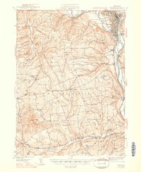
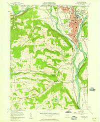
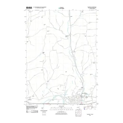
 1969 Waverly1971 Print · USGSThe river and rail corridors of the New York-Pennsylvania border are captured here in the late sixties as the village of WAVERLY thrives. Researchers can trace the legacy of the Lehigh Valley railroad or locate local landmarks like the St John of the Cross Monastery and Hicks Cem.3 unique versions available
 - 1981 Map of Towanda, 1982 Print
 1981 Towanda1982 Print · USGSThe Susquehanna Valley at the turn of the 1980s reveals a region of mountain forests and busy river towns along the New York border. Researchers can trace the legacy of the CONRAIL lines through Sayre or locate remote landmarks like Armenia Mountain and Mt Pisgah State Park.
 - 1986 Map of Elmira
 1986 Elmira1986 Print · USGSThe Southern Tier and Finger Lakes regions meet in this mid-eighties survey of the river valleys and high ridges. Genealogists can trace family names at Forest Lawn Memorial Park or locate homesteads near Breesport and Newark Valley.
 - 1992 Map of Elmira, 1993 Print
 1992 Elmira1993 Print · USGSThe Finger Lakes and Southern Tier regions are captured in the early nineties as industrial hubs like Elmira and Endicott thrived alongside university life in Ithaca. Genealogists and researchers can trace the CONRAIL rail corridors, family hilltops such as Hornby Hill, and the extensive Newtown Battlefield Reservation.
 - 1995 Map of Sayre, 1999 Print
 1995 Sayre1999 Print · USGSThe northern Tier of Pennsylvania at the New York border is shown here in the mid-1990s, centered on the river confluence at Sayre and Athens. Genealogists and local historians can trace family locations at Tioga Point Cemetery, Milan Cem, and numerous named schools like the McDuffy Sch.
 - 2010 Map of Waverly, 2010 Print
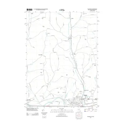
 2010 Waverly2010 Print · USGSCovers Waverly, including Barton, Chemung, and other nearby areas
 - 2013 Map of Waverly, 2013 Print
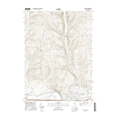
 2013 Waverly2013 Print · USGSCovers Waverly, including Barton, Chemung, and other nearby areas
 - 2016 Map of Waverly, 2016 Print
 2016 Waverly2016 Print · USGSCovers Waverly, including Barton, Chemung, and other nearby areas
Showing maps 1-25 of 28
Top cities near Waverly
- Horseheads historical maps
- Barton historical maps
- Elmira historical maps
- Sayre historical maps
- Candor historical maps
- Tioga historical maps
See more
Frequently asked questions
- What are the different types of historical maps available for Waverly?
- What is the oldest map of Waverly?
- Where can I purchase historical maps of Waverly for my home or office?
- Where can I download high-res historical maps of Waverly?
- Are there historical topographic maps available for Waverly?
- Is there historical aerial imagery available for Waverly?
- Where are historical maps of Waverly sourced from?