Old Maps of Leland, North Carolina
Explore 23 old maps of Leland, spanning from 1942 to today. These high-resolution historic maps reveal how streets, neighborhoods, landmarks, and natural features evolved over time — perfect for genealogy, metal detecting, research, and local history exploration.
What you can do with these maps:
- See how Leland changed over time: Compare historical maps to modern-day views to trace roads, homesites, rail lines & more.
- View detailed metadata: Each map includes creators, publishers, year, scale, and archive source.
- Overlay maps with satellite & LiDAR: Visualize the past alongside modern tools to explore terrain & human change.
- Trusted historical sources: Maps sourced from the USGS, Library of Congress, and other archives.
- Access maps your way: View online, download high-res files, or order prints for personal or research use.
Start exploring old maps of Leland to uncover forgotten places, hidden landmarks, and the deep history beneath your feet.
Leland, NC maps
(23)- 1942 Map of Wilmington
 1942 Wilmington1942 Print · USGSCovers Leland, including Wilmington, Carolina Beach, and other nearby areas
 - 1943 Map of Winnabow, 1962 Print
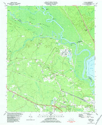
 1943 Winnabow1962 Print · USGSCovers Leland, including Navassa, Bell Swamp, and other nearby areas2 unique versions available
 - 1944 Map of Winnabow
 1944 Winnabow1944 Print · USGSCovers Leland, including Navassa, Bell Swamp, and other nearby areas
 - 1948 Map of Wilmington
 1948 Wilmington1948 Print · USGSCovers Leland, including Wilmington, Carolina Beach, and other nearby areas2 unique versions available
 - 1950 Map of Winnabow
 1950 Winnabow1950 Print · USGSCovers Leland, including Navassa, Bell Swamp, and other nearby areas
 - 1953 Map of Florence, 1964 Print
 1953 Florence1964 Print · USGSCovers Leland, including Fayetteville, Florence, and other nearby areas3 unique versions available
 - 1953 Map of Beaufort, 1965 Print
 1953 Beaufort1965 Print · USGSCovers Leland, including Wilmington, Jacksonville, and other nearby areas3 unique versions available
 - 1954 Map of Florence
 1954 Florence1954 Print · USGSCovers Leland, including Fayetteville, Florence, and other nearby areas
 - 1954 Map of Beaufort
 1954 Beaufort1954 Print · USGSCovers Leland, including Wilmington, Jacksonville, and other nearby areas
 - 1954 Map of Acme, 1957 Print
 1954 Acme1957 Print · USGSCovers Leland, including Navassa, Northwest, and other nearby areas2 unique versions available
 - 1970 Map of Wilmington, 1973 Print
 1970 Wilmington1973 Print · USGSCovers Leland, including Wilmington, Navassa, and other nearby areas3 unique versions available
 - 1972 Map of Beaufort, 1975 Print
 1972 Beaufort1975 Print · USGSCovers Leland, including Wilmington, Jacksonville, and other nearby areas
 - 1980 Map of Leland, 1985 Print
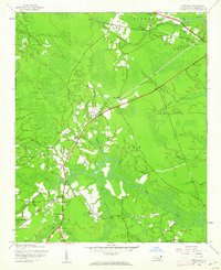
 1980 Leland1985 Print · USGSCovers Leland, including Navassa, Northwest, and other nearby areas
 - 1980 Map of Winnabow, 1985 Print
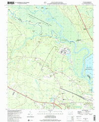
 1980 Winnabow1985 Print · USGSCovers Leland, including Navassa, Bell Swamp, and other nearby areas
 - 1980 Map of Wilmington, 1985 Print
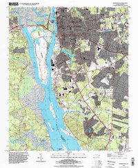
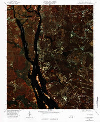 1980 Wilmington1985 Print · USGSCovers Leland, including Wilmington, Navassa, and other nearby areas
 - 1984 Map of Leland
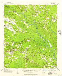
 1984 Leland1984 Print · USGSCovers Leland, including Navassa, Northwest, and other nearby areas2 unique versions available
 - 1984 Map of Wilmington, 1985 Print
 1984 Wilmington1985 Print · USGSCovers Leland, including Wilmington, Carolina Beach, and other nearby areas
 - 1986 Map of Whiteville
 1986 Whiteville1986 Print · USGSCovers Leland, including Boiling Spring Lakes, Whiteville, and other nearby areas
 - 1990 Map of Wilmington
 1990 Wilmington1990 Print · USGSCovers Leland, including Wilmington, Carolina Beach, and other nearby areas
 - 1990 Map of Whiteville
 1990 Whiteville1990 Print · USGSCovers Leland, including Boiling Spring Lakes, Whiteville, and other nearby areas
 - 1990 Map of Winnabow, 1991 Print
 1990 Winnabow1991 Print · USGSCovers Leland, including Navassa, Bell Swamp, and other nearby areas2 unique versions available
 - 1993 Map of Wilmington, 1999 Print
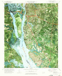
 1993 Wilmington1999 Print · USGSCovers Leland, including Wilmington, Navassa, and other nearby areas
 - 1997 Map of Leland, 2001 Print
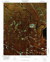
 1997 Leland2001 Print · USGSCovers Leland, including Navassa, Northwest, and other nearby areas
End of results
Showing maps 1-23 of 23
Top cities near Leland
- Wilmington historical maps
- Boiling Spring Lakes historical maps
- Carolina Beach historical maps
- Wrightsville Beach historical maps
- Kure Beach historical maps
- Navassa historical maps
See more
Top neighborhoods of Leland
- The Forest at Mallory Creek historical maps
- The Lakes at Brunswick Forest historical maps
- The Pinnacle at Mallory Creek Plantation historical maps
- Shelmore at Brunswick Forest historical maps
Frequently asked questions
- What are the different types of historical maps available for Leland?
- What is the oldest map of Leland?
- Where can I purchase historical maps of Leland for my home or office?
- Where can I download high-res historical maps of Leland?
- Are there historical topographic maps available for Leland?
- Is there historical aerial imagery available for Leland?
- Where are historical maps of Leland sourced from?