Old Maps of Toledo, Oregon
Explore 18 old maps of Toledo, spanning from 1942 to today. These high-resolution historic maps reveal how streets, neighborhoods, landmarks, and natural features evolved over time — perfect for genealogy, metal detecting, research, and local history exploration.
What you can do with these maps:
- See how Toledo changed over time: Compare historical maps to modern-day views to trace roads, homesites, rail lines & more.
- View detailed metadata: Each map includes creators, publishers, year, scale, and archive source.
- Overlay maps with satellite & LiDAR: Visualize the past alongside modern tools to explore terrain & human change.
- Trusted historical sources: Maps sourced from the USGS, Library of Congress, and other archives.
- Access maps your way: View online, download high-res files, or order prints for personal or research use.
Start exploring old maps of Toledo to uncover forgotten places, hidden landmarks, and the deep history beneath your feet.
Toledo, OR maps
(18)- 1942 Map of Toledo, 1946 Print
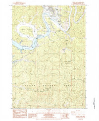
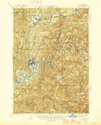 1942 Toledo1946 Print · USGSCoastal Oregon's timber and rail networks are frozen in time just after the war, showing the industrial heart of the Yaquina watershed. Genealogists can trace family roots through locations like Riverside Cem or rural schools such as Moody Sch and Bear Creek Sch.
 - 1953 Map of Salem
 1953 Salem1953 Print · USGSMid-century Oregon comes to life through this detailed survey of the Willamette Valley and the adjacent Pacific coastline. Researchers can trace the rail lines of the Southern Pacific RR, visit rural hubs like Fairview School, or locate coastal landmarks like the Yaquina Head Lighthouse.
 - 1954 Map of Salem
 1954 Salem1954 Print · USGSMid-century Western Oregon is centered on the productive Willamette River valley as its cities and infrastructure expand toward the mountains. Genealogists and historians can trace the rail lines of the Southern Pacific RR and Oregon Electric Ry through towns like Dallas, Independence, and Brownsville.
 - 1957 Map of Toledo, 1960 Print
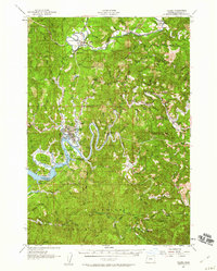 1957 Toledo1960 Print · USGSCoastal Oregon timber and rail networks are preserved here in the late fifties, centered on the vital river ports of Lincoln County. Local historians can trace the paths of the Logging Railroad and Southern Pacific past rural landmarks like Sunnyridge Grange and Riverside Cem.2 unique versions available
 - 1960 Map of Salem, 1968 Print
 1960 Salem1968 Print · USGSThe Willamette Valley and the surrounding mountain ranges are shown here in the 1960s during a period of significant reservoir construction. Genealogists and historians can trace rail lines like the Oregon Electric and find communities from Lincoln City on the coast to Sweet Home and Mill City in the foothills.2 unique versions available
 - 1962 Map of Salem
 1962 Salem1962 Print · USGSThe Willamette Valley and the surrounding Oregon ranges are captured here in the early sixties, showing the vital growth of the state's primary agricultural and academic corridor. Researchers can trace the mid-century footprints of Oregon State University and the University of Oregon, alongside rural landmarks like Camp Adair and Black Butte Mine.
 - 1963 Map of Salem
 1963 Salem1963 Print · USGSMid-century Oregon comes into focus as the Willamette Valley’s timber and agricultural industries meet the growing campuses of Oregon State University and the University of Oregon. Researchers can trace old rail lines like the Oregon Electric Railway and locate family plots at Siletz Cem or Dallas Cem.
 - 1980 Map of Corvallis, 1981 Print
 1980 Corvallis1981 Print · USGSThe Oregon Coast Range meets the fertile Willamette Valley in the early eighties, documenting a landscape of timber, agriculture, and growing college towns. Genealogists and historians can trace old rail lines like the Southern Pacific or locate landmarks like Marys Peak and the College of Education.
 - 1984 Map of Toledo North
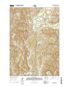
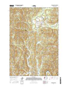
 1984 Toledo North1984 Print · USGSThe Siletz River valley and the industrial corridor of Toledo are captured here in the mid-1980s. Local researchers can trace family landmarks and timber history through sites like Paul Washington Cem, the Siletz Indian Reservation, and the Southern Pacific rail line.
 - 1984 Map of Toledo South
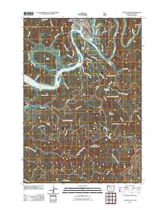
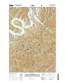
 1984 Toledo South1984 Print · USGSThe Yaquina River valley in the mid-eighties shows a landscape of timber and rail operations centered around Toledo. Researchers can trace old family sites and rural infrastructure like the Sunnyridge Grange, Butler Bridge, and the Historical Monument at Craigie Point.
 - 2011 Map of Toledo South, 2011 Print
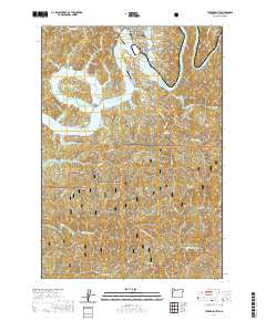
 2011 Toledo South2011 Print · USGSCovers Toledo, including Sunnyridge, Elk City, and other nearby areas
 - 2014 Map of Toledo North, 2014 Print
 2014 Toledo North2014 Print · USGSCovers Toledo, including Siletz, Fruitvale, and other nearby areas
 - 2017 Map of Toledo North, 2017 Print
 2017 Toledo North2017 Print · USGSCovers Toledo, including Siletz, Fruitvale, and other nearby areas
 - 2017 Map of Toledo South, 2017 Print
 2017 Toledo South2017 Print · USGSCovers Toledo, including Sunnyridge, Elk City, and other nearby areas
 - 2020 Map of Toledo South, 2020 Print
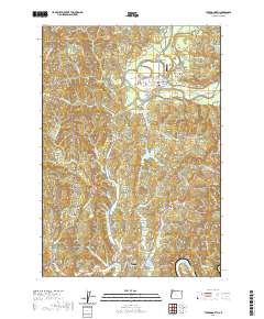
 2020 Toledo South2020 Print · USGSCovers Toledo, including Sunnyridge, Elk City, and other nearby areas
 - 2020 Map of Toledo North, 2020 Print
 2020 Toledo North2020 Print · USGSCovers Toledo, including Siletz, Fruitvale, and other nearby areas
 - 2023 Map of Toledo South, 2023 Print
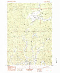
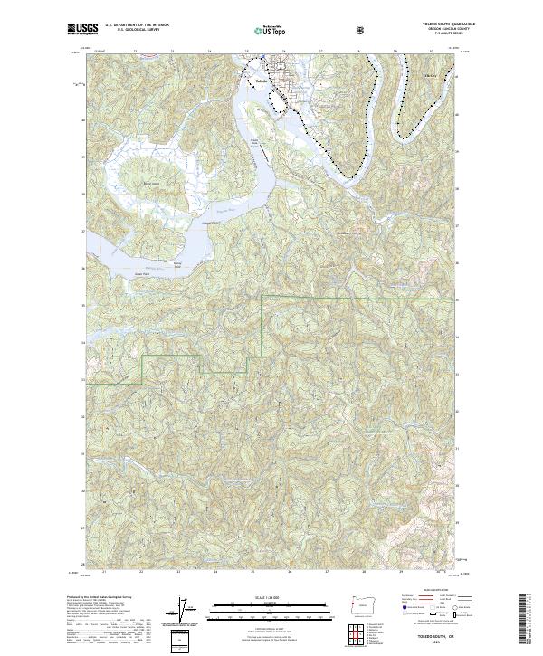 2023 Toledo South2023 Print · USGSThe riverfront and timberlands south of Toledo are captured here in the early 2020s, showing a landscape shaped by coastal sloughs and the Yaquina River. Genealogists and historians can trace the roads and waterways connecting Elk City to landmarks like Boone Island and the Siuslaw National Forest.
 - 2024 Map of Toledo North, 2024 Print
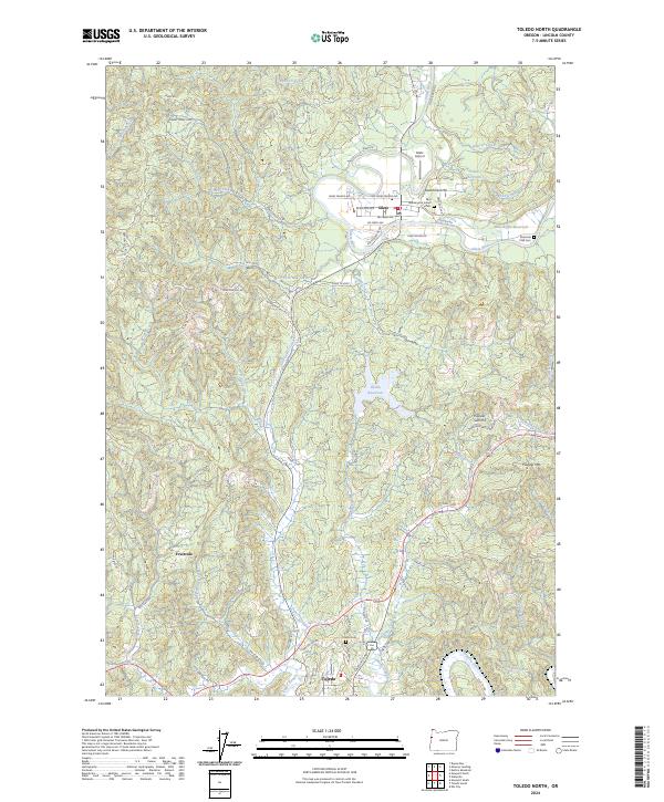 2024 Toledo North2024 Print · USGSThe Siletz River valley and the timbered ridges of Lincoln County are captured in this contemporary view of the Oregon Coast Range. Researchers can locate the Washington Indian Cem near Siletz, trace the winding path of the Yaquina River, or study the rural layout of Fruitvale and Government Hill.
End of results
Showing maps 1-18 of 18
Top cities near Toledo
Frequently asked questions
- What are the different types of historical maps available for Toledo?
- What is the oldest map of Toledo?
- Where can I purchase historical maps of Toledo for my home or office?
- Where can I download high-res historical maps of Toledo?
- Are there historical topographic maps available for Toledo?
- Is there historical aerial imagery available for Toledo?
- Where are historical maps of Toledo sourced from?