Old Maps of Breezy Point, Licking Creek Township
Explore 17 old maps of Breezy Point, spanning from 1925 to today. These high-resolution historic maps reveal how streets, neighborhoods, landmarks, and natural features evolved over time — perfect for genealogy, metal detecting, research, and local history exploration.
What you can do with these maps:
- See how Breezy Point changed over time: Compare historical maps to modern-day views to trace roads, homesites, rail lines & more.
- View detailed metadata: Each map includes creators, publishers, year, scale, and archive source.
- Overlay maps with satellite & LiDAR: Visualize the past alongside modern tools to explore terrain & human change.
- Trusted historical sources: Maps sourced from the USGS, Library of Congress, and other archives.
- Access maps your way: View online, download high-res files, or order prints for personal or research use.
Start exploring old maps of Breezy Point to uncover forgotten places, hidden landmarks, and the deep history beneath your feet.
Breezy Point, Licking Creek Township maps
(17)- 1925 Map of Needmore
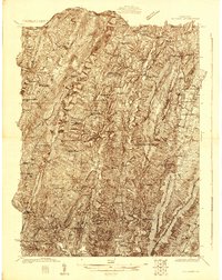 1925 Needmore1925 Print · USGSFulton County’s ridges and valleys are meticulously detailed in the mid-1920s, showing the early path of the Lincoln Highway. Researchers can locate dozens of country institutions, from the Old Mountain House to the Sideling Hill Baptist Church and Sipes Mill.
 - 1935 Map of Needmore
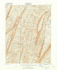 1935 Needmore1935 Print · USGSFulton County settlements and ridge-and-valley farmsteads are documented here in the years before the Second World War. Genealogists can trace family names at Wink Cem or locate rural landmarks like Hammans Store, Sipes Mill, and Big Cove Tannery.
 - 1939 Map of Needmore
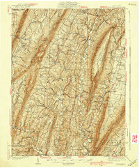 1939 Needmore1939 Print · USGSFulton County and the Bedford-Franklin borderlands appear here in the late thirties, showing a rural landscape defined by steep ridges and narrow valleys. Researchers can locate family landmarks like Sipes Mill, Wink Cem, and the Big Cove Tannery.3 unique versions available
 - 1948 Map of Cumberland
 1948 Cumberland1948 Print · USGSMid-century Appalachia and the Shenandoah Valley are shown in detail, documenting the industrial and transportation hubs of the tri-state area. Genealogists can trace family roots through settlements like Double Tollgate and Bunker Hill or along the Baltimore & Ohio RR.3 unique versions available
 - 1952 Map of Cumberland
 1952 Cumberland1952 Print · USGSThe Potomac Highlands and the Shenandoah Valley are revealed in this early 1950s survey of the Appalachian interior. Researchers can trace the river-and-rail corridors connecting Cumberland, Winchester, and the recreational waters of Deep Creek Lake.
 - 1956 Map of Cumberland, 1966 Print
 1956 Cumberland1966 Print · USGSThe tri-state Highlands in the mid-1950s show a landscape shaped by coal, timber, and the massive presence of the Baltimore & Ohio RR. Researchers can trace the industrial corridor from Cumberland through the Allegheny Mountains to mountain retreats like Deep Creek Lake.6 unique versions available
 - 1957 Map of Cumberland
 1957 Cumberland1957 Print · USGSThe Potomac River valley and the ridges of the Allegheny Front define this mid-century landscape at the intersection of Maryland, West Virginia, and Pennsylvania. Trace the steam-era rail lines of the Baltimore and Ohio RR or locate rural landmarks like St Stephens Church and Stony River Dam.
 - 1961 Map of Cumberland
 1961 Cumberland1961 Print · USGSThe tri-state highlands of Maryland, West Virginia, and Pennsylvania are shown in the mid-twentieth century as a complex landscape of ridges and river valleys. Researchers can trace the winding Potomac River and find old rail-and-river towns like Cumberland, Keyser, and Morgantown.
 - 1962 Map of Cumberland
 1962 Cumberland1962 Print · USGSThe central Appalachians meet at the height of the mid-century industrial era, showing the rugged topography between Morgantown and Winchester. Genealogists can trace family lands near Fort Necessity or along the vital Baltimore & Ohio RR corridors.
 - 1967 Map of Meadow Grounds, 1970 Print
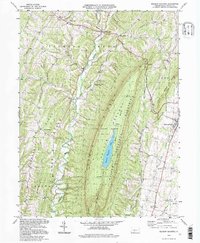
 1967 Meadow Grounds1970 Print · USGSFulton County’s ridge-and-valley landscape is captured here in the late 1960s, showing a region defined by steep timbered slopes and narrow creek bottoms. Genealogists and local historians can trace rural congregations at Asbury Ch and Rock Hill Ch or locate family markers at Wink Cem.3 unique versions available
 - 1981 Map of Cumberland, 1982 Print
 1981 Cumberland1982 Print · USGSThe tri-state region of Maryland, Pennsylvania, and West Virginia is captured here in the early eighties as a landscape of industrial history and ridgeline geography. Researchers can trace the heritage of the C & O Canal and the B & O RR through mountain gaps and coal towns like Eckhart Mines and Frostburg.2 unique versions available
 - 1994 Map of Meadow Grounds, 1997 Print
 1994 Meadow Grounds1997 Print · USGSFulton County settlements and rugged ridge-and-valley terrain are captured here in the mid-1990s as the landscape balances conservation and community. Researchers can locate family landmarks like Wink Cem, Bethlehem Ch, and the valley village of Harrisonville.
 - 2010 Map of Meadow Grounds, 2010 Print
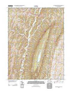
 2010 Meadow Grounds2010 Print · USGSCovers Breezy Point, including Ayr Township, Licking Creek Township, and other nearby areas
 - 2013 Map of Meadow Grounds, 2013 Print
 2013 Meadow Grounds2013 Print · USGSCovers Breezy Point, including Ayr Township, Licking Creek Township, and other nearby areas
 - 2016 Map of Meadow Grounds, 2016 Print
 2016 Meadow Grounds2016 Print · USGSCovers Breezy Point, including Ayr Township, Licking Creek Township, and other nearby areas
 - 2019 Map of Meadow Grounds, 2019 Print
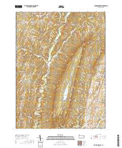 2019 Meadow Grounds2019 Print · USGSCovers Breezy Point, including Ayr Township, Licking Creek Township, and other nearby areas
 - 2023 Map of Meadow Grounds, 2023 Print
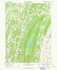
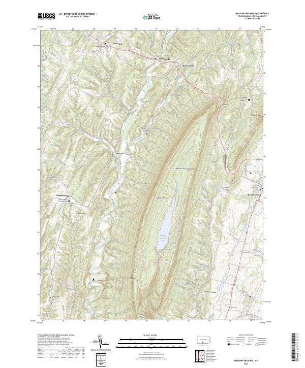 2023 Meadow Grounds2023 Print · USGSFulton County’s ridge-and-valley landscape is documented here in the early twenty-first century, centered on the high basin of Meadow Grounds Lake. Local historians can trace family ties at Green Hill Presbyterian Cem, Wink Cem, and the Bethlehem United Brethren Cem.
End of results
Showing maps 1-17 of 17
Top cities near Breezy Point
- Metal Township historical maps
- Mercersburg historical maps
- McConnellsburg historical maps
- Todd Township historical maps
- Three Springs historical maps
- Broad Top City historical maps
See more
Frequently asked questions
- What are the different types of historical maps available for Breezy Point?
- What is the oldest map of Breezy Point?
- Where can I purchase historical maps of Breezy Point for my home or office?
- Where can I download high-res historical maps of Breezy Point?
- Are there historical topographic maps available for Breezy Point?
- Is there historical aerial imagery available for Breezy Point?
- Where are historical maps of Breezy Point sourced from?