Old Maps of Portsmouth, Virginia
Explore 40 old maps of Portsmouth, spanning from 1907 to today. These high-resolution historic maps reveal how streets, neighborhoods, landmarks, and natural features evolved over time — perfect for genealogy, metal detecting, research, and local history exploration.
What you can do with these maps:
- See how Portsmouth changed over time: Compare historical maps to modern-day views to trace roads, homesites, rail lines & more.
- View detailed metadata: Each map includes creators, publishers, year, scale, and archive source.
- Overlay maps with satellite & LiDAR: Visualize the past alongside modern tools to explore terrain & human change.
- Trusted historical sources: Maps sourced from the USGS, Library of Congress, and other archives.
- Access maps your way: View online, download high-res files, or order prints for personal or research use.
Start exploring old maps of Portsmouth to uncover forgotten places, hidden landmarks, and the deep history beneath your feet.
Portsmouth, VA maps
(40)- 1907 Map of Norfolk
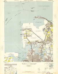
 1907 Norfolk1907 Print · USGSCoastal Virginia is mapped here at the dawn of the twentieth century, during the bustle of the great Jamestown Exposition. Researchers can trace the early rail-and-canal economy through the Albemarle and Chesapeake Canal, the Navy Yard, and historic outposts like the Cape Henry Light.
 - 1921 Map of Newport News
 1921 Newport News1921 Print · USGSThe Virginia tidewater area comes alive in the early twentieth century, showing a landscape defined by maritime industry and massive military installations. Genealogists and historians can trace rail lines and early settlements from Camp Stuart down to Jolliff School and the Dismal Swamp.4 unique versions available
 - 1944 Map of Norfolk South
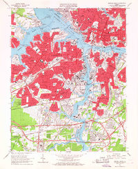
 1944 Norfolk South1944 Print · USGSThe Hampton Roads waterfront at the height of World War II reveals a landscape defined by naval power and rail-to-sea industry. Genealogists and historians can trace neighborhood growth in Craddock, locate family sites near Hope Chapel, or map the early footprints of Portlock and Berkley.
 - 1948 Map of Norfolk South
 1948 Norfolk South1948 Print · USGSMid-century Hampton Roads is defined here by its massive naval installations and complex rail-to-river freight networks. Genealogists and historians can trace neighborhood growth in Alexander Park, locate family plots in Elmwood Cemetery, or follow the industrial lines of the Belt Line and Virginian railroads.2 unique versions available
 - 1948 Map of Norfolk North
 1948 Norfolk North1948 Print · USGSCoastal Virginia at the height of its mid-century military importance shows a dense network of naval bases and growing suburbs. Genealogists and historians can trace the development of Titustown, Ocean View, and Colonial Heights alongside landmarks like Forest Lawn Cemetery and the Marine Hospital.2 unique versions available
 - 1952 Map of Bowers Hill
 1952 Bowers Hill1952 Print · USGSIn the early 1950s, the border of Nansemond and Norfolk counties was a landscape of tide-water branches and heavy rail. Genealogists can trace family footprints around Pughsville, Sunray, and numerous rural landmarks like Glebe Ch and Florence School.
 - 1952 Map of Newport News
 1952 Newport News1952 Print · USGSThe industrial waterfront of Hampton Roads and the James River are captured here just after the war. Local researchers can trace the rail yards of the C & O, the military grounds of Camp Stuart, and the oyster-working life at Eclipse.
 - 1953 Map of Norfolk, 1954 Print
 1953 Norfolk1954 Print · USGSCoastal Virginia and northeastern North Carolina appear here during the post-war industrial boom, showing the critical rail-and-sea connections of Hampton Roads. Genealogists can trace family roots through rural landmarks like Gethsemane Ch, the Caledonia State Prison Farm, and the vast interior of the Dismal Swamp.4 unique versions available
 - 1955 Map of Newport News, 1958 Print
 1955 Newport News1958 Print · USGSThe Virginia Peninsula and Southside meet at the James River just as the mid-century port economy peaked. Genealogists and historians can trace neighborhood landmarks from Newport News to Eclipse, locating Mt Zion Ch and the Chesapeake & Ohio Ry docks.
 - 1955 Map of Bowers Hill, 1958 Print
 1955 Bowers Hill1958 Print · USGSCoastal Virginia in the mid-fifties shows a landscape of tidal creeks and burgeoning suburbs bridged by a massive rail network. Researchers can trace family sites at Pughsville, find old rural landmarks like Glebe Church, or locate the historic Portsmouth Airfield.
 - 1955 Map of Norfolk North, 1958 Print
 1955 Norfolk North1958 Print · USGSMid-century Norfolk and the Hampton Roads waterfront are captured here during a peak of military and rail activity. Genealogists and historians can trace neighborhood growth in Larchmont or locate vanished infrastructure like the Virginian Railway and Fort Wool.
 - 1955 Map of Norfolk South, 1958 Print
 1955 Norfolk South1958 Print · USGSCoastal Virginia during the mid-fifties reveals a bustling maritime economy centered on the Elizabeth River and its industrial branches. Trace the evolution of neighborhoods and naval sites like the Norfolk Naval Shipyard or Virginia State College.
 - 1964 Map of Newport News South, 1966 Print
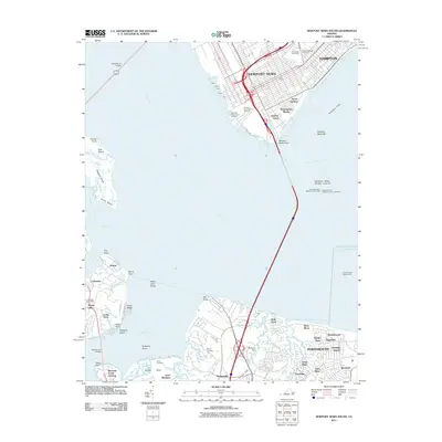
 1964 Newport News South1966 Print · USGSThe industrial waterfront of Newport News and Hampton meets the marshy southern shore of the James River in the mid-1960s. Genealogists and historians can trace urban neighborhoods around Greenlawn Cemetery or locate old coastal settlements like Eclipse and Crittenden.7 unique versions available
 - 1965 Map of Bowers Hill, 1967 Print
 1965 Bowers Hill1967 Print · USGSSoutheastern Virginia at the height of the mid-century suburban boom shows the convergence of the Dismal Swamp with a growing transportation hub. Researchers can trace the development of Nansemond Shores or locate the old Sunray settlement near the Seaboard Air Line rail corridors.4 unique versions available
 - 1965 Map of Norfolk North, 1968 Print
 1965 Norfolk North1968 Print · USGSMid-century Norfolk is defined by its massive naval installations and the busy waterfront of the Elizabeth and Lafayette Rivers. Researchers can trace the layout of the Naval Base, find the Old Point Ferry landing, or locate family plots in Forest Lawn Cemetery.6 unique versions available
 - 1965 Map of Norfolk South, 1968 Print
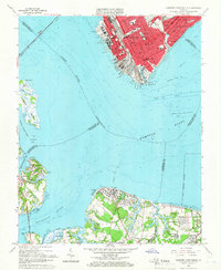
 1965 Norfolk South1968 Print · USGSThe Tidewater region in the mid-sixties reveals a dense network of military installations and maritime industry along the Elizabeth River. Researchers can trace the layout of the U S Naval Shipyard, find the site of the former South Norfolk Airport, and locate established neighborhoods like Cavalier Manor.6 unique versions available
 - 1985 Map of Norfolk, 1986 Print
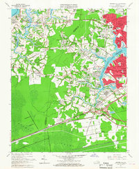
 1985 Norfolk1986 Print · USGSThe Tidewater region in the mid-eighties shows the dense urban expansion of the coastal cities alongside the preservation of the Great Dismal Swamp. Researchers can trace rural family-named crossroads and historic transit routes like the Seaboard Coast Line or find Somerton and Lake Drummond.3 unique versions available
 - 1994 Map of Norfolk South, 2000 Print
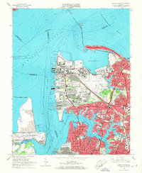
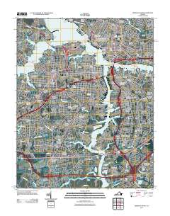
 1994 Norfolk South2000 Print · USGSCoastal Virginia during the late twentieth century reveals a landscape shaped by massive naval facilities and dense residential corridors. Genealogists and historians can trace neighborhood development and cemeteries like Mt Calvary Cemetery alongside industrial hubs like the U S Naval Shipyard.
 - 1994 Map of Newport News South, 2000 Print
 1994 Newport News South2000 Print · USGSCoastal Virginia in the mid-nineties shows the evolving maritime landscape of the Lower Peninsula and the Tidewater region. Researchers can trace historic local sites like Greenlawn Cemetery, the James River Bridge, and the community of Eclipse.
 - 1994 Map of Bowers Hill, 2000 Print
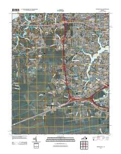
 1994 Bowers Hill2000 Print · USGSThe Tidewater region meets the northern reaches of the Great Dismal Swamp in this late-century survey. Genealogists can trace family names and local landmarks like Shoulders Hill, Hodges Ferry, and the Poplar Run Ch Cem.
 - 2011 Map of Newport News South, 2011 Print
 2011 Newport News South2011 Print · USGSCovers Portsmouth, including Newport News, Christophers Shores, and other nearby areas
 - 2011 Map of Norfolk South, 2011 Print
 2011 Norfolk South2011 Print · USGSCovers Portsmouth, including Norfolk, Portlock, and other nearby areas
 - 2011 Map of Bowers Hill, 2011 Print
 2011 Bowers Hill2011 Print · USGSCovers Portsmouth, including Boone, Deanes, and other nearby areas
 - 2011 Map of Norfolk North, 2011 Print
 2011 Norfolk North2011 Print · USGSCovers Portsmouth, including Cottage Road Park, Oakdale Farms, and other nearby areas
 - 2013 Map of Newport News South, 2013 Print
 2013 Newport News South2013 Print · USGSCovers Portsmouth, including Newport News, Christophers Shores, and other nearby areas
Showing maps 1-25 of 40
Top cities of Portsmouth
Frequently asked questions
- What are the different types of historical maps available for Portsmouth?
- What is the oldest map of Portsmouth?
- Where can I purchase historical maps of Portsmouth for my home or office?
- Where can I download high-res historical maps of Portsmouth?
- Are there historical topographic maps available for Portsmouth?
- Is there historical aerial imagery available for Portsmouth?
- Where are historical maps of Portsmouth sourced from?