Old Maps of Cookstown, Spotsylvania County
Explore 17 old maps of Cookstown, spanning from 1887 to today. These high-resolution historic maps reveal how streets, neighborhoods, landmarks, and natural features evolved over time — perfect for genealogy, metal detecting, research, and local history exploration.
What you can do with these maps:
- See how Cookstown changed over time: Compare historical maps to modern-day views to trace roads, homesites, rail lines & more.
- View detailed metadata: Each map includes creators, publishers, year, scale, and archive source.
- Overlay maps with satellite & LiDAR: Visualize the past alongside modern tools to explore terrain & human change.
- Trusted historical sources: Maps sourced from the USGS, Library of Congress, and other archives.
- Access maps your way: View online, download high-res files, or order prints for personal or research use.
Start exploring old maps of Cookstown to uncover forgotten places, hidden landmarks, and the deep history beneath your feet.
Cookstown, Spotsylvania County maps
(17)- 1887 Map of Spottsylvania
 1887 Spottsylvania1887 Print · USGSCentral Virginia in the late 1880s remains a landscape of river fords and crossroads shops before modern development. Genealogists and historians can trace the locations of the Vaucluse Gold Mine, Wilderness Tavern, and the path of the Narrow Gauge Railroad.
 - 1892 Map of Spottsylvania
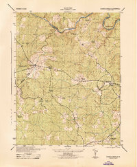
 1892 Spottsylvania1892 Print · USGSCentral Virginia’s post-war landscape is captured here in the late nineteenth century, showing a rural economy defined by gold mining and river crossings. Genealogists can trace family footprints at Todds Tavern, the Vaucluse Gold Mine, and along the Narrow Gauge Railroad.6 unique versions available
 - 1943 Map of Chancellorsville, 1957 Print
 1943 Chancellorsville1957 Print · USGSSpotsylvania and Orange counties are captured during the early 1940s, highlighting the preserved grounds of the Wilderness National Military Park. Genealogists can trace family footprints at Paynes Store, Zion Hill Church, and the Parker School located near the Ni River.
 - 1944 Map of Chancellorsville
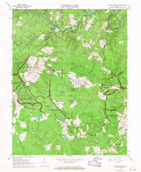
 1944 Chancellorsville1944 Print · USGSSpotsylvania County is documented during the mid-1940s, highlighting the overlapping layers of Civil War history and rural Virginia life. Researchers can trace the grounds of Wilderness National Military Park or locate local landmarks like Wilderness Church and Parker School.
 - 1948 Map of Washington
 1948 Washington1948 Print · USGSThe Potomac and Chesapeake regions in the late 1940s reveal a landscape of expanding military reach and deep-rooted Tidewater settlements. Trace old rail corridors like the Richmond Fredericksburg & Potomac RR or locate landmarks like the Wakefield Washington Monument and St. Marys College.2 unique versions available
 - 1957 Map of Washington, 1966 Print
 1957 Washington1966 Print · USGSThe mid-Atlantic region during the mid-fifties and early sixties reveals a landscape of growing suburbs and vital military outposts. Researchers can trace historic river towns and shorelines from Alexandria to the Hooper Islands and St Clements Island.5 unique versions available
 - 1961 Map of Washington
 1961 Washington1961 Print · USGSThe mid-Atlantic region in the late fifties is presented in remarkable detail, from the Blue Ridge foothills to the Chesapeake Eastern Shore. Researchers can trace historic river landings and military sites like Mount Vernon, Fort Belvoir, and Point Lookout.2 unique versions available
 - 1966 Map of Chancellorsville, 1968 Print
 1966 Chancellorsville1968 Print · USGSSpotsylvania County is shown here in the mid-sixties, where the preserved Civil War battlefields meet the quiet rural life of the Virginia Piedmont. Genealogists and historians can locate markers like Hamiltons Thicket, the Jackson Furnace ruins, and family-named landmarks such as Elys Ford.
 - 1973 Map of Chancellorsville, 1974 Print
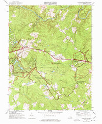 1973 Chancellorsville1974 Print · USGSSpotsylvania County is shown in the early seventies, centered on the preserved battlefields of the Wilderness. Historians can trace the location of Battle Trenches and Furnace Ruins near old settlements like Cookstown and Wilderness Corner.3 unique versions available
 - 1983 Map of Fredericksburg, 1984 Print
 1983 Fredericksburg1984 Print · USGSThe Virginia and Maryland tidewater region comes into sharp focus during the early 1980s, centered on the historic Rappahannock and Potomac river valleys. Researchers can trace the boundaries of the Fredericksburg-Spotsylvania National Military Park alongside growing residential areas and military sites like Fort A.P. Hill Military Reservation.2 unique versions available
 - 1989 Map of Washington
 1989 Washington1989 Print · USGSThe Potomac River valley and Chesapeake Bay are shown in comprehensive detail during the late 1980s. Genealogists and historians can trace the transition from urban Alexandria to the rural Northern Neck, locating landmarks like Mount Vernon and Stratford Hall.
 - 1994 Map of Chancellorsville, 1999 Print
 1994 Chancellorsville1999 Print · USGSSpotsylvania County in the mid-1990s reflects a landscape defined by Civil War memory and modern residential growth. Genealogists and historians can locate markers like the Jackson Monument and Hays Monument alongside settlements such as Wilderness Corner and Cookstown.
 - 2011 Map of Chancellorsville, 2011 Print
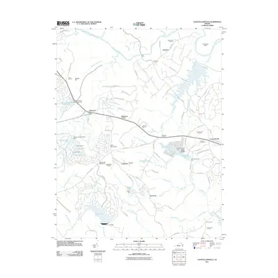 2011 Chancellorsville2011 Print · USGSCovers Cookstown, including Lake of the Woods, Lake Wilderness, and other nearby areas
 - 2013 Map of Chancellorsville, 2013 Print
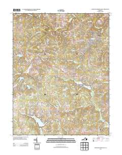 2013 Chancellorsville2013 Print · USGSCovers Cookstown, including Lake of the Woods, Lake Wilderness, and other nearby areas
 - 2016 Map of Chancellorsville, 2016 Print
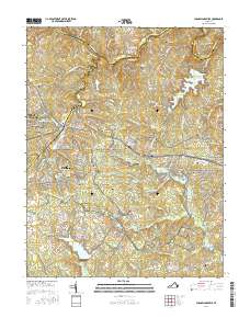 2016 Chancellorsville2016 Print · USGSCovers Cookstown, including Lake of the Woods, Lake Wilderness, and other nearby areas
 - 2019 Map of Chancellorsville, 2019 Print
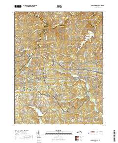 2019 Chancellorsville2019 Print · USGSCovers Cookstown, including Lake of the Woods, Lake Wilderness, and other nearby areas
 - 2022 Map of Chancellorsville, 2022 Print
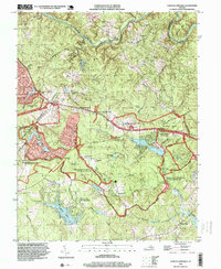
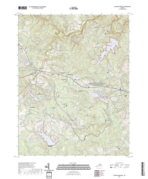 2022 Chancellorsville2022 Print · USGSSpotsylvania County’s storied Civil War battlefields and rural crossroads are preserved here in the early twenty-first century. Genealogists and historians can locate numerous family burial sites like the Ellwood Family Cem and trace the historic grounds of Hazel Grove.
End of results
Showing maps 1-17 of 17
Frequently asked questions
- What are the different types of historical maps available for Cookstown?
- What is the oldest map of Cookstown?
- Where can I purchase historical maps of Cookstown for my home or office?
- Where can I download high-res historical maps of Cookstown?
- Are there historical topographic maps available for Cookstown?
- Is there historical aerial imagery available for Cookstown?
- Where are historical maps of Cookstown sourced from?