Old Maps of Sappho, Washington
Explore 13 old maps of Sappho, spanning from 1935 to today. These high-resolution historic maps reveal how streets, neighborhoods, landmarks, and natural features evolved over time — perfect for genealogy, metal detecting, research, and local history exploration.
What you can do with these maps:
- See how Sappho changed over time: Compare historical maps to modern-day views to trace roads, homesites, rail lines & more.
- View detailed metadata: Each map includes creators, publishers, year, scale, and archive source.
- Overlay maps with satellite & LiDAR: Visualize the past alongside modern tools to explore terrain & human change.
- Trusted historical sources: Maps sourced from the USGS, Library of Congress, and other archives.
- Access maps your way: View online, download high-res files, or order prints for personal or research use.
Start exploring old maps of Sappho to uncover forgotten places, hidden landmarks, and the deep history beneath your feet.
Sappho, WA maps
(13)- 1935 Map of Lake Pleasant, 1958 Print
 1935 Lake Pleasant1958 Print · USGSThe Olympic Peninsula's logging and ranching frontier is captured here in the mid-1930s. Genealogists and historians can trace family sites like Klahoose Ranch and timber infrastructure including the Big Creek Shingle Mill and several logging railroads.
 - 1942 Map of Lake Pleasant
 1942 Lake Pleasant1942 Print · USGSThe interior of the Olympic Peninsula comes into focus just before the mid-forties, showing a landscape defined by timber and transit. You can trace the path of the U.S. Government Spruce Canal and locate family landmarks like the Maxfield Ranch or Beaver Sch.
 - 1953 Map of Cape Flattery, 1968 Print
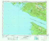 1953 Cape Flattery1968 Print · USGSThe maritime border between Washington and British Columbia comes into sharp focus during the mid-century, detailing the remote coastal reaches of both nations. Researchers can trace the layout of the Makah Indian Res and fishing outposts like Sekiu and Port Renfrew.2 unique versions available
 - 1957 Map of Lake Pleasant, 1958 Print
 1957 Lake Pleasant1958 Print · USGSClallam County timber country is caught in a moment of mid-century industrial transition, where logging camps and rail grades define the forest. Local historians can trace old homesteads and work sites like Tyee (Beaver PO), the Beaver School, and the Clallam Honor Camp.3 unique versions available
 - 1963 Map of Cape Flattery
 1963 Cape Flattery1963 Print · USGSThe Pacific Northwest coast and the entrance to the Puget Sound are captured in detail during the early 1960s. Researchers can trace remote coastal settlements and tribal lands including the Makah Indian Reserve, Port Renfrew, and the timber town of Sekiu.
 - 1984 Map of Lake Pleasant
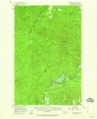
 1984 Lake Pleasant1984 Print · USGSThe Olympic Peninsula timberlands and the Soleduck River corridor are captured here during the mid-eighties. Researchers can trace the legacy of regional logging via the Old Railroad Grade or locate local landmarks like Sappho and the Soleduck Salmon Hatchery.
 - 1986 Map of Cape Flattery, 1987 Print
 1986 Cape Flattery1987 Print · USGSThe tip of the Olympic Peninsula and the waters of the Strait of Juan de Fuca are captured here in the mid-eighties. Researchers can trace tribal lands like the Makah Indian Reservation, the remote Old Royal settlement, and maritime landmarks like Cemetery Point.
 - 1999 Map of Lake Pleasant, 2001 Print
 1999 Lake Pleasant2001 Print · USGSThe Lake Pleasant area of the Olympic Peninsula shows a landscape of timber-covered hills and vital river valleys in the late 1990s. Researchers can trace the footprint of Sappho, locate the Sol Duc Salmon Hatchery, and explore the limits of Maxfield Prairie.
 - 2011 Map of Lake Pleasant, 2011 Print
 2011 Lake Pleasant2011 Print · USGSCovers Sappho, including Beaver, Clallam County, and other nearby areas
 - 2014 Map of Lake Pleasant, 2014 Print
 2014 Lake Pleasant2014 Print · USGSCovers Sappho, including Beaver, Clallam County, and other nearby areas
 - 2017 Map of Lake Pleasant, 2017 Print
 2017 Lake Pleasant2017 Print · USGSCovers Sappho, including Beaver, Clallam County, and other nearby areas
 - 2020 Map of Lake Pleasant, 2020 Print
 2020 Lake Pleasant2020 Print · USGSCovers Sappho, including Beaver, Clallam County, and other nearby areas
 - 2023 Map of Lake Pleasant, 2023 Print
 2023 Lake Pleasant2023 Print · USGSClallam County in the modern era maintains its character as a timber and river crossroads on the Olympic Peninsula. Local researchers can trace the valley floor geography around Beaver and Sappho, identifying historic open spaces like Tyee Prairie and the banks of the Sol Duc River.
End of results
Showing maps 1-13 of 13
Top cities near Sappho
Frequently asked questions
- What are the different types of historical maps available for Sappho?
- What is the oldest map of Sappho?
- Where can I purchase historical maps of Sappho for my home or office?
- Where can I download high-res historical maps of Sappho?
- Are there historical topographic maps available for Sappho?
- Is there historical aerial imagery available for Sappho?
- Where are historical maps of Sappho sourced from?