Old Maps of Balford, Washington
Explore 6 old maps of Balford, spanning from 1919 to today. These high-resolution historic maps reveal how streets, neighborhoods, landmarks, and natural features evolved over time — perfect for genealogy, metal detecting, research, and local history exploration.
What you can do with these maps:
- See how Balford changed over time: Compare historical maps to modern-day views to trace roads, homesites, rail lines & more.
- View detailed metadata: Each map includes creators, publishers, year, scale, and archive source.
- Overlay maps with satellite & LiDAR: Visualize the past alongside modern tools to explore terrain & human change.
- Trusted historical sources: Maps sourced from the USGS, Library of Congress, and other archives.
- Access maps your way: View online, download high-res files, or order prints for personal or research use.
Start exploring old maps of Balford to uncover forgotten places, hidden landmarks, and the deep history beneath your feet.
Balford, WA maps
(6)- 1919 Map of Van Zandt
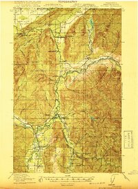 1919 Van Zandt1919 Print · USGSWhatcom County's timber and mining frontier is captured here at the end of the Great War, as railroads pushed deep into the river valleys. Genealogists can locate family landmarks like Heislers Ranch, the Peoples Store, and the Old Nooksack Mine along the Nooksack River.2 unique versions available
 - 1951 Map of Van Zandt, 1953 Print
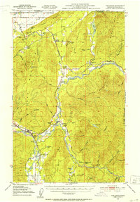 1951 Van Zandt1953 Print · USGSThe Nooksack River valley in the early fifties shows a bustling network of rail lines and timber-town outposts. Genealogists and local historians can trace family-named sites like Heislers Ranch or locate the Welcome Grange and the Limestone Quarry near Kendall.2 unique versions available
 - 1957 Map of Victoria, 1960 Print
 1957 Victoria1960 Print · USGSThe San Juan Islands and the North Cascades coastline are shown in detail during the late fifties, a period of significant military and industrial presence. Researchers can trace historic rail lines like the Great Northern or locate sites such as the Whidbey Island Naval Air Sta and Friday Harbor.4 unique versions available
 - 1972 Map of Kendall, 1976 Print
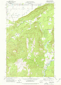 1972 Kendall1976 Print · USGSWhatcom County in the early 1970s shows a landscape of timber and mining at the foot of Sumas Mountain. Trace family roots at St Peters Cem, locate the former settlement at Balford (Site), and follow the path of the Chicago Milwaukee St Paul and Pacific railroad.2 unique versions available
 - 1975 Map of Bellingham, 1977 Print
 1975 Bellingham1977 Print · USGSNorthwest Washington in the mid-seventies is captured here, from the Canadian border at Blaine to the San Juan Islands. Researchers can trace tribal lands on the Lummi Indian Reservation, find rural settlements like Cokedale, or follow the Burlington Northern rail lines.
 - 2023 Map of Kendall, 2023 Print
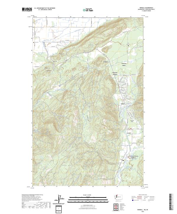 2023 Kendall2023 Print · USGSThe foothills of the Northern Cascades come into focus in this contemporary look at the Kendall area, where mountain peaks meet growing valley settlements. Genealogists can locate Saint Peters Cem and the Nooksack Salmon Hatchery while tracing the waters of Saar Creek and Kendall Lake.
End of results
Showing maps 1-6 of 6
Top cities near Balford
Frequently asked questions
- What are the different types of historical maps available for Balford?
- What is the oldest map of Balford?
- Where can I purchase historical maps of Balford for my home or office?
- Where can I download high-res historical maps of Balford?
- Are there historical topographic maps available for Balford?
- Is there historical aerial imagery available for Balford?
- Where are historical maps of Balford sourced from?