2022 Map of Centuria
USGS Topo · Published 2022About this map
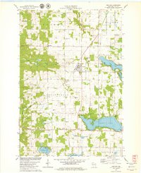
Centuria serves as a central hub in this Polk County landscape, where the local economy and geography are defined by a dense concentration of glacial lakes and historic transportation corridors. The village is flanked by significant water bodies such as Deer Lake and Long Lake, while the north-south alignment of the Ice Age National Scenic Trl and the Gandy Dancer State Trl follow the path of former rail beds, illustrating the transition from industrial transport to modern recreational use.
Find a feature on this map
41 named features on this map. Tap any name to fly to it.
Don’t see what you’re looking for? This feature index may not catch every label — zoom into the map to look around manually.
Map Details
Editions of this 2022 Centuria Map
This is the sole edition of this map. No revisions or reprints were ever made.