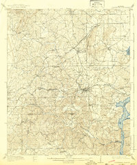
1909 Map of Columbiana
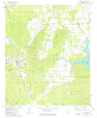
USGS Topo · Published 1968About this map
Columbiana serves as a central hub in this early 20th-century landscape, where the Southern RR and the Louisville and Nashville RR intersect at Springs Junction. The map details a transition from the agricultural plains to the more varied terrain around Kelley Mtn and The Narrows along the Coosa River. Social and communal life is anchored by numerous rural institutions, including Kingdom Church, Goodhope Church, and the Summer Hill School. Industry and travel are reflected in the prominence of historical routes like the Selma and Huntsville Road and the Rome and Dalton Road. South of Shelby, the map follows the winding paths of Waxahatchee Creek and Buxahatchee Creek down toward the Shelby Co Chilton Co Boundary Line, revealing a network of family-named landmarks such as Sawyer Cove and Watson Ford.
Find a feature on this map
67 named features on this map. Tap any name to fly to it.
Don’t see what you’re looking for? This feature index may not catch every label — zoom into the map to look around manually.
Map Details
Editions of this 1909 Columbiana Map
This is the sole edition of this map. No revisions or reprints were ever made.
Historical Maps of Kingdom Crossroads Through Time
4 maps found