2023 Map of Copenhagen
USGS Topo · Published 2023About this map
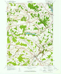
Copenhagen and Champion serve as the primary nodes of settlement in this northern New York landscape, situated where the terrain begins its ascent toward the Tug Hill plateau. The Deer River carves a significant path through the southeastern portion of the map, marked by notable natural landmarks including High Falls and Kings Falls. These water features historically drove the development of local industry and the orientation of early roadways like Woodbattle Rd and Number Three Rd.
Find a feature on this map
80 named features on this map. Tap any name to fly to it.
Don’t see what you’re looking for? This feature index may not catch every label — zoom into the map to look around manually.
Map Details
Editions of this 2023 Copenhagen Map
This is the sole edition of this map. No revisions or reprints were ever made.
Historical Maps of Pinckney Through Time
3 maps found