
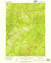
1990 Map of Dutchman Butte
USGS Topo · Published 1990About this map
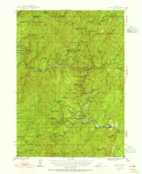
Dutchman Lookout stands as a primary vantage point over this section of the Southern Oregon mountains, where the borders of Douglas, Curry, and Josephine counties converge. The drainage system of the West Fork Cow Creek and its many tributaries, such as the humorously named Sweat Creek and No Sweat Creek, dictates the movement through this difficult terrain. Settlement is sparse, represented instead by localized industrial sites like a Borrow Pit and various unnamed Quarry locations. High-elevation clearings such as Walker Prairie and Jackass Prairie provide breaks in the timbered slopes of Hayes Ridge and Ninemile Mountain. Transport is limited to narrow forest passages and the specifically noted Goat Trail, reflecting a landscape primarily utilized for timber management and resource extraction in the late twentieth century.
Find a feature on this map
28 named features on this map. Tap any name to fly to it.
Don’t see what you’re looking for? This feature index may not catch every label — zoom into the map to look around manually.
Map Details
Editions of this 1990 Dutchman Butte Map
This is the sole edition of this map. No revisions or reprints were ever made.
Other maps of this area
1946 · Galice
USGS Topo · 1:62,500
1946 · Dutchman Butte
USGS Topo · 1:62,500
1948 · Galice
USGS Topo · 1:62,500
1948 · Dutchman Butte
USGS Topo · 1:62,500
1954 · Bone Mountain
USGS Topo · 1:62,500
1954 · Marial
USGS Topo · 1:62,500

1955 · Medford
USGS Topo · 1:250,000

1957 · Medford
USGS Topo · 1:250,000

1958 · Medford
USGS Topo · 1:250,000
1989 · Kelsey Peak
USGS Topo · 1:24,000