1944 Map of Enosburg Falls
USGS Topo · Published 1944About this map
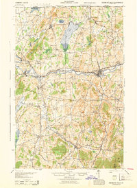
The Missisquoi River flows through the heart of Franklin County, Vermont, anchoring a landscape defined by small mill towns and dairy farming communities during the mid-1940s. The village of Enosburg Falls serves as a primary hub, situated where the Central Vermont railroad tracks follow the river's winding course. This era shows a dense network of one-room schoolhouses, such as Pumpkin Village Sch, Egypt Sch, and McCarty Sch, illustrating the localized nature of rural education before modern consolidation. To the north, Lake Carmi is surrounded by early recreational sites like Patten Camp and Miller Camp, while the rail junction at Sheldon Junction marks the intersection with the St Johnsbury and Lake Champlain RR. The map preserves local industrial and curious place names, ranging from Gilberts Tannery in Enosburg Center to the enigmatically named Lost Nation near the southern border.
Find a feature on this map
98 named features on this map. Tap any name to fly to it.
Don’t see what you’re looking for? This feature index may not catch every label — zoom into the map to look around manually.
Map Details
Editions of this 1944 Enosburg Falls Map
This is the sole edition of this map. No revisions or reprints were ever made.
Other maps of this area

1913 · Milton
USGS Topo · 1:48,000

1914 · St. Albans
USGS Topo · 1:48,000

1915 · Milton
USGS Topo · 1:62,500

1916 · St. Albans
USGS Topo · 1:62,500

1919 · Montgomery
USGS Topo · 1:62,500

1920 · Franklin Pond
USGS Topo · 1:62,500

1920 · Montgomery
USGS Topo · 1:62,500

1922 · Enosburg Falls
USGS Topo · 1:48,000

1924 · Enosburg Falls
USGS Topo · 1:62,500

1925 · Jay Peak
USGS Topo · 1:62,500