1948 Map of Fallbrook
USGS Topo · Published 1964About this map
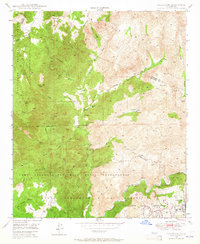
The Camp Joseph H Pendleton Naval Reservation dominates this 1948 landscape, illustrating the significant military footprint in northern San Diego County during the post-war era. The survey captures a transition from private agricultural holdings to federal installations, with the sprawling Fallbrook Naval Reservation and a designated Target Range situated near the headwaters of the Santa Margarita River.
Find a feature on this map
35 named features on this map. Tap any name to fly to it.
Don’t see what you’re looking for? This feature index may not catch every label — zoom into the map to look around manually.
Map Details
Editions of this 1948 Fallbrook Map
This is the sole edition of this map. No revisions or reprints were ever made.
Other maps of this area

1901 · Southern California Sheet No. 1
USGS Topo · 1:250,000

1901 · Elsinore
USGS Topo · 1:125,000

1901 · San Luis Rey
USGS Topo · 1:125,000

1904 · Southern California Sheet No. 2
USGS Topo · 1:250,000

1904 · Southern California Sheet No. 1
USGS Topo · 1:250,000

1941 · Margarita Peak
USGS Topo · 1:62,500

1942 · Lake Elsinore
USGS Topo · 1:62,500

1942 · Margarita Peak
USGS Topo · 1:62,500

1942 · Temecula
USGS Topo · 1:62,500

1942 · Murrieta
USGS Topo · 1:62,500
Featured Places
- Fallbrook, CA
- Marine Corps Base Camp Pendleton, CA
- Santa Margarita Groves, CA
- De Luz Heights, CA
- De Luz, CA