
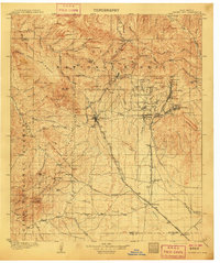
1947 Map of Fort Bayard
USGS Topo · Published 1971About this map
The Continental Divide winds through the high country of the Pinos Altos Mountains in this late-1940s topographic study. This landscape is defined by the expansive Fort Bayard Military Reservation, which occupies much of the central and eastern terrain. The survey captures a moment of transition for the region’s settlements, showing the established town of Pinos Altos in the north and the growing communities of Arenas Valley, Central, and Bayard in the south.
Find a feature on this map
33 named features on this map. Tap any name to fly to it.
Don’t see what you’re looking for? This feature index may not catch every label — zoom into the map to look around manually.
Map Details
Editions of this 1947 Fort Bayard Map
This is the sole edition of this map. No revisions or reprints were ever made.
Other maps of this area
1909 · Silver City
USGS Topo · 1:125,000

1937 · Santa Rita
USGS Topo · 1:24,000
1947 · Allie Canyon
USGS Topo · 1:24,000
1947 · Twin Sisters
USGS Topo · 1:24,000

1948 · Twin Sisters
USGS Topo · 1:24,000

1948 · Santa Rita
USGS Topo · 1:24,000

1948 · Allie Canyon
USGS Topo · 1:24,000

1948 · Hurley East
USGS Topo · 1:24,000

1949 · Fort Bayard
USGS Topo · 1:24,000

1949 · Hurley East
USGS Topo · 1:24,000