1944 Map of Hampstead
USGS Topo · Published 1944About this map
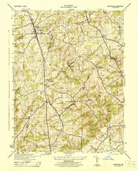
The Western Maryland Railway corridor serves as the primary spine for this mid-century landscape, threading together a string of agricultural and industrial hamlets. Commercial and social life in the 1940s is anchored by settlements like Hampstead and Greenmount in the north, while industrial sites like Trenton Mill and Kees Mill indicate a rural economy still tied to local water power and rail access. The map reveals a dense network of country churches, including St Pauls Church and Piney Grove Church, which alongside the Mt Gilead Cemetery, provide essential waypoints for genealogists tracing family roots in this portion of the Carroll and Baltimore County borderlands. The transition from established post offices at Arcadia Upperco P O to smaller rail stops like Boring and Fowblesburg illustrates the era's reliance on the railway for both communication and freight.
Find a feature on this map
37 named features on this map. Tap any name to fly to it.
Don’t see what you’re looking for? This feature index may not catch every label — zoom into the map to look around manually.
Map Details
Editions of this 1944 Hampstead Map
This is the sole edition of this map. No revisions or reprints were ever made.
Other maps of this area

1892 · Ellicott
USGS Topo · 1:62,500

1894 · Ellicott
USGS Topo · 1:62,500

1894 · Baltimore
USGS Topo · 1:62,500

1899 · Baltimore
USGS Topo · 1:62,500

1900 · Parkton
USGS Topo · 1:62,500

1902 · Parkton
USGS Topo · 1:62,500

1904 · Baltimore
USGS Topo · 1:62,500

1905 · Westminster
USGS Topo · 1:62,500

1906 · Ellicott
USGS Topo · 1:62,500

1908 · Patapsco
USGS Topo · 1:125,000