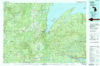
1991 Map of L'Anse
USGS Topo · Published 1991About this map
The L'Anse Indian Reservation anchors the head of Keweenaw Bay, showing a landscape defined by the deep indentations of the Lake Superior shoreline. This early 1990s documentation reveals the intricate interface of water and land, from the Abbaye Peninsula and Huron Bay to the interior highlands of the Huron Mountains. The terrain rises to notable peaks like Mount Arvon and Mount Curwood, while the industrial and transport history is marked by the Soo Line railroad and several interior mines.
Find a feature on this map
145 named features on this map. Tap any name to fly to it.
Don’t see what you’re looking for? This feature index may not catch every label — zoom into the map to look around manually.
Map Details
Editions of this 1991 L'Anse Map
2 editions found
Other maps of this area

1895 · Ned Lake
USGS Topo · 1:62,500

1895 · Perch Lake
USGS Topo · 1:62,500

1899 · Witbeck
USGS Topo · 1:62,500

1915 · Houghton
USGS Topo · 1:62,500

1946 · Chassell
USGS Topo · 1:24,000

1946 · South Range
USGS Topo · 1:24,000

1948 · South Range
USGS Topo · 1:24,000

1948 · Chassell
USGS Topo · 1:24,000

1949 · Rockland
USGS Topo · 1:62,500

1950 · Greenland
USGS Topo · 1:62,500