Loading...
Loading map...2023 Map of Mount Jewett
USGS Topo · Published 2023About this map
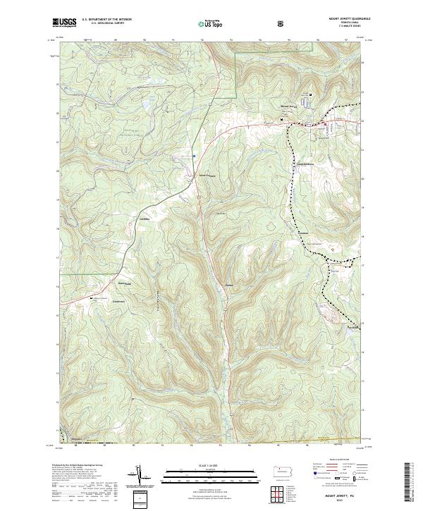
The Allegheny National Forest covers much of this landscape, where the plateau is dissected by the headwaters of the West Branch Clarion River and Kinzua Creek. The borough of Mount Jewett serves as the primary hub, situated near the high point of Howard Hill. Local history is anchored at the Nebo Lutheran Chapel and Cem, reflecting the area's Swedish-American heritage.
Find a feature on this map
72 named features on this map. Tap any name to fly to it.
Don’t see what you’re looking for? This feature index may not catch every label — zoom into the map to look around manually.
Map Details
Date Portrayed2023
Date Published2023
PublisherU.S. Geological Survey
Map TypeTopographic
Scale1:24000
Physical Dimensions24 x 29 inches
Editions of this 2023 Mount Jewett Map
This is the sole edition of this map. No revisions or reprints were ever made.
Historical Maps of Kanesholm Through Time
1 maps found
Featured Locations
- Hamlin Township, PA
- Wetmore Township, PA
- Mount Jewett, PA
- Hutchins, Sergeant Township
- Campbelltown, Hamlin Township
Source Details
SourceU.S. Geological Survey
CopyrightPublic Domain