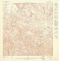
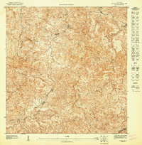
1947 Map of Naranjito NO
USGS Topo · Published 1947About this map
Rio De La Plata carves a deep, winding path through this portion of the northern karst and central highlands, marking the intricate terrain of the mid-1940s. The landscape is defined by its agricultural and spiritual hubs, including the Colonia Piña and a series of rural houses of worship such as Iglesia Achiote and Iglesia Guadiana. This 1943 topography records a pre-industrial network of small settlements and neighborhood divisions, where municipal boundaries for Toa Alta, Naranjito, and Bayamon intersect amidst steep ridges and narrow stream valleys like Quebrada Cruz. The presence of small clusters at El Portón and El Ocho alongside the Primera Iglesia de Cristo illustrates the localized social structure of the era, where mountain roads followed the natural contours of the island's interior before modern highway expansion.
Find a feature on this map
13 named features on this map. Tap any name to fly to it.
Don’t see what you’re looking for? This feature index may not catch every label — zoom into the map to look around manually.
Map Details
Editions of this 1947 Naranjito NO Map
This is the sole edition of this map. No revisions or reprints were ever made.
Other maps of this area

1940 · Vega Alta
USGS Topo · 1:30,000

1941 · Bayamon
USGS Topo · 1:30,000

1946 · Corozal
USGS Topo · 1:30,000

1946 · Vega Alta
USGS Topo · 1:30,000

1946 · Naranjito
USGS Topo · 1:30,000
1947 · Naranjito SO
USGS Topo · 1:10,000
1947 · Corozal NE
USGS Topo · 1:10,000
1947 · Naranjito SE
USGS Topo · 1:10,000

1947 · Bayamon
USGS Topo · 1:30,000
1947 · Corozal SE
USGS Topo · 1:10,000
Featured Places
- Hacienda El Paraíso, Toa Alta
- Hacienda Leila, Toa Alta
- Sector Los Corozos, Toa Alta
- Reparto Rosario, Bayamón
- Sector Los Fonseca, Bayamón