2022 Map of Neal
USGS Topo · Published 2022About this map
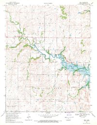
The settlement of Neal sits along the northern edge of the Flint Hills region, serving as a quiet focal point in a landscape defined by cattle ranching and rolling prairie. This 2022 survey captures the area's intricate drainage system, where Walnut Creek and Homer Creek wind through the limestone-underlaid terrain. Local history is anchored by the Neal Cem and Rocky Ford Cem, which provide essential touchstones for genealogical research in this part of Greenwood County. The geography is characterized by distinct rises like Tipperary Hill and named crossings such as Rocky Ford, reflecting a time when physical landmarks were vital for navigation across the open range. Modern infrastructure follows long-established routes, including the east-west path of Highway 54, which bisects the quadrangle and connects the rural homesteads scattered along the creek bottoms.
Find a feature on this map
50 named features on this map. Tap any name to fly to it.
Don’t see what you’re looking for? This feature index may not catch every label — zoom into the map to look around manually.
Map Details
Editions of this 2022 Neal Map
This is the sole edition of this map. No revisions or reprints were ever made.