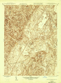
1946 Map of Pittsfield West
USGS Topo · Published 1946About this map
Onota Lake and the western reaches of Pittsfield anchor this mid-century landscape, where the urban grid meets the high ridges of the Berkshire Barrier Range. To the west, the historic communal settlement of Shaker Village is situated near the base of Shaker Mtn, while the New York Central RR cuts a diagonal path through the valley, passing near West Pittsfield and Richmond Pond. The map reveals a transition from industrial and civic hubs like Wahconah Park and the Pittsfield Cem to the rugged summits of Yokun Seat and Mahanna Cobble. Along the New York border, the terrain climbs toward Mt Lebanon and Lebanon Springs, illustrating the natural topographic boundary that defined early Massachusetts expansion. Local landmarks such as the Pittsfield Airport and the recreational waters of Morewood Lake reflect the area's development during the 1940s.
Find a feature on this map
90 named features on this map. Tap any name to fly to it.
Don’t see what you’re looking for? This feature index may not catch every label — zoom into the map to look around manually.
Map Details
Editions of this 1946 Pittsfield West Map
This is the sole edition of this map. No revisions or reprints were ever made.
Other maps of this area

1886 · Greylock
USGS Topo · 1:62,500

1886 · Becket
USGS Topo · 1:62,500

1888 · Becket
USGS Topo · 1:62,500

1888 · Berlin
USGS Topo · 1:62,500

1888 · Pittsfield
USGS Topo · 1:62,500

1890 · Pittsfield
USGS Topo · 1:62,500

1890 · Berlin
USGS Topo · 1:62,500

1891 · Greylock
USGS Topo · 1:62,500

1893 · Becket
USGS Topo · 1:62,500

1893 · Greylock
USGS Topo · 1:62,500