
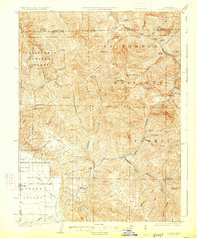
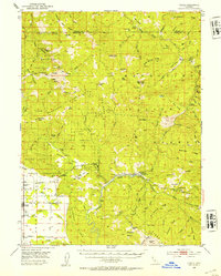
1967 Map of Plaskett Ridge
USGS Topo · Published 1969About this map
The Mendocino National Forest defines this high-elevation landscape, where the Black Butte River carves through complex ridges in both Mendocino and Glenn counties. During the mid-1960s, this area remained largely remote, accessible by a network of pack trails and jeep paths that linked isolated landmarks. Historic homesteads and administrative sites like Carpenter Place, Keller Place, and the Grizzly Flat Station suggest a legacy of high-country ranching and forest management. Physical landmarks such as Etsel Ridge and Plaskett Ridge dominate the topography, while smaller features like Coffee Mill Flat and Surveyors Flat provide evidence of early survey camps and localized land use. Water sources, including Keller Lake and O'Neil Spring, served as vital stops for travelers navigating between Thurmon Rock and the river valley below.
Find a feature on this map
56 named features on this map. Tap any name to fly to it.
Don’t see what you’re looking for? This feature index may not catch every label — zoom into the map to look around manually.
Map Details
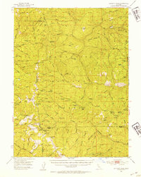
Editions of this 1967 Plaskett Ridge Map
This is the sole edition of this map. No revisions or reprints were ever made.
Other maps of this area
1926 · Covelo
USGS Topo · 1:62,500
1929 · Eden Valley
USGS Topo · 1:62,500
1952 · Hull Mountain
USGS Topo · 1:62,500
1952 · Eden Valley
USGS Topo · 1:62,500
1952 · Covelo
USGS Topo · 1:62,500
1952 · Anthony Peak
USGS Topo · 1:62,500

1957 · Ukiah
USGS Topo · 1:250,000

1960 · Ukiah
USGS Topo · 1:250,000
1966 · Sanhedrin Mtn
USGS Topo · 1:24,000

1967 · Newhouse Ridge
USGS Topo · 1:24,000