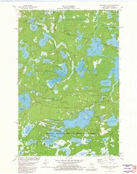
1981 Map of Tenderfoot Lake
USGS Topo · Published 1982About this map
The Michigan-Wisconsin border cuts through a dense landscape of glacial lakes and managed timberlands in this 1981 survey. Straddling the line between the Ottawa National Forest to the north and the Northern Highland-American Legion State Forest to the south, the area is defined by its complex water network. Significant water bodies like Tenderfoot Lake and Plum Lake are connected by the Presque Isle River East Branch and the Ontonagon River. The map reveals the early modern road system designed for forest management and recreation, including named routes such as Timber Wolf Road and Blue Heron Road. Topographic details show small-scale resource extraction with scattered Gravel Pits and public access points that highlight the transition of this wilderness into a premier Midwestern outdoor destination during the late twentieth century.
Find a feature on this map
79 named features on this map. Tap any name to fly to it.
Don’t see what you’re looking for? This feature index may not catch every label — zoom into the map to look around manually.
Map Details
Editions of this 1981 Tenderfoot Lake Map
This is the sole edition of this map. No revisions or reprints were ever made.
Other maps of this area

1939 · Trout Lake
USGS Topo · 1:48,000

1946 · Star Lake
USGS Topo · 1:48,000

1946 · Trout Lake
USGS Topo · 1:48,000

1949 · Trout Lake
USGS Topo · 1:48,000

1950 · Star Lake
USGS Topo · 1:48,000

1952 · Thayer
USGS Topo · 1:62,500

1955 · Marenisco
USGS Topo · 1:62,500

1955 · Starlake
USGS Topo · 1:62,500

1955 · Boulder Junction
USGS Topo · 1:62,500

1958 · Iron River
USGS Topo · 1:250,000