1985 Map of Virginia Beach
USGS Topo · Published 1985About this map
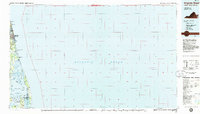
Virginia Beach and the coastal barrier islands of the Mid-Atlantic are captured here during a period of significant mid-1980s development. The landscape is a study in contrasts between the established urban grids of North Virginia Beach and the sprawling military installations like Fort Story Mil Res and the U S Naval Amphibious Base. To the south, the map details the intricate waterways and marshlands of the Back Bay National Wildlife Refuge and Mackay Island National Wildlife Refuge, where the Virginia North Carolina state line cuts across Knotts Island Bay.
Find a feature on this map
53 named features on this map. Tap any name to fly to it.
Don’t see what you’re looking for? This feature index may not catch every label — zoom into the map to look around manually.
Map Details
Editions of this 1985 Virginia Beach Map
This is the sole edition of this map. No revisions or reprints were ever made.
Other maps of this area

1893 · Virginia Beach
USGS Topo · 1:125,000

1907 · Norfolk
USGS Topo · 1:125,000

1916 · Back Bay
USGS Topo · 1:62,500

1918 · Cape Henry
USGS Topo · 1:62,500

1919 · Cape Henry
USGS Topo · 1:62,500

1939 · Moyock
USGS Topo · 1:62,500

1940 · Barco
USGS Topo · 1:62,500

1943 · Back Bay
USGS Topo · 1:62,500

1943 · Richmond
USGS Topo · 1:250,000

1946 · Moyock
USGS Topo · 1:62,500