Old Maps of Paata, Chuuk
Explore 2 old maps of Paata, spanning from 1997 to today. These high-resolution historic maps reveal how streets, neighborhoods, landmarks, and natural features evolved over time — perfect for genealogy, metal detecting, research, and local history exploration.
What you can do with these maps:
- See how Paata changed over time: Compare historical maps to modern-day views to trace roads, homesites, rail lines & more.
- View detailed metadata: Each map includes creators, publishers, year, scale, and archive source.
- Overlay maps with satellite & LiDAR: Visualize the past alongside modern tools to explore terrain & human change.
- Trusted historical sources: Maps sourced from the USGS, Library of Congress, and other archives.
- Access maps your way: View online, download high-res files, or order prints for personal or research use.
Start exploring old maps of Paata to uncover forgotten places, hidden landmarks, and the deep history beneath your feet.
Paata, TRK maps
(2)- 1997 Map of Unikappi, 2003 Print
 1997 Unikappi2003 Print · USGSThe islands of Pata and Polle are shown in high detail during the late twentieth century as they appeared within the Chuuk Lagoon. Researchers can trace the layout of small settlements like Unikappi, Wichap, and Pukuan along with several local schools.
 - 1997 Map of Tol, 2003 Print
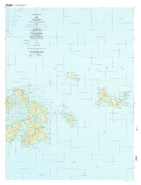 1997 Tol2003 Print · USGSThe islands of Faichuk are mapped here in the late twentieth century, showing the intricate settlement patterns across Chuuk Lagoon. Genealogists and historians can trace local centers like Wichuk, Winisi, and Fanapenges alongside trails and schools.
End of results
Showing maps 1-2 of 2
Top neighborhoods of Paata
- Unumenei historical maps
- Wino historical maps
- Epin historical maps
- Epinnou historical maps
- Nefor historical maps
- Neo historical maps
See more
Frequently asked questions
- What are the different types of historical maps available for Paata?
- What is the oldest map of Paata?
- Where can I purchase historical maps of Paata for my home or office?
- Where can I download high-res historical maps of Paata?
- Are there historical topographic maps available for Paata?
- Is there historical aerial imagery available for Paata?
- Where are historical maps of Paata sourced from?