1900s (20th Century) Maps of Fanif, Yap
Explore 2 historic maps of Fanif from the 1900s (20th Century). These maps offer a rare glimpse into what life looked like during the 1900s — showing old roads, neighborhoods, homes, and landmarks that have changed or disappeared over time.
Whether you're researching your family's past, planning a metal detecting trip, or studying how Fanif's landscape evolved across the 1900s, these high-resolution maps are a powerful tool for exploring the history of this region.
- Focus on a specific era: All maps on this page are from the 1900s, giving you a focused view of this time period.
- See what’s changed: Compare century-old streets, trails, and buildings to today's modern landscape using overlays and satellite layers.
- Research with precision: Use these maps for genealogy, historical research, land use analysis, or educational projects.
- View, download, or print: Maps are fully viewable online in high resolution, and can be downloaded or printed for your own records.
Start exploring Fanif's history through authentic maps from the 1900s. This is your window into the past.
Fanif, YAP maps
(2)- 1983 Map of Yap Islands (Waqab)
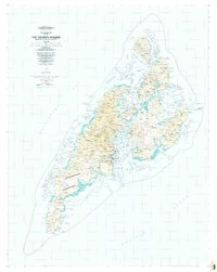 1983 Yap Islands (Waqab)1983 Print · USGSThe Yap Islands are captured in the early eighties as they transitioned into a new era of self-governance. Researchers can trace traditional village sites like Gagnagun and Bechiyal or locate landmarks such as St Josephs Church and the Yap Airport.
 - 1996 Map of Yap Islands (Waqab), 2003 Print
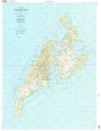 1996 Yap Islands (Waqab)2003 Print · USGSThe Yap Islands in the mid-1990s show a blend of traditional village life and modern infrastructure across the Federated States of Micronesia. Researchers can trace the coastal layout of Colonia, locate specific mission sites like Saint Joseph Church, and find historic Fish Traps near Wanyan.
End of results
Showing maps 1-2 of 2
Frequently asked questions
- What are the different types of historical maps available for Fanif?
- What is the oldest map of Fanif?
- Where can I purchase historical maps of Fanif for my home or office?
- Where can I download high-res historical maps of Fanif?
- Are there historical topographic maps available for Fanif?
- Is there historical aerial imagery available for Fanif?
- Where are historical maps of Fanif sourced from?