Old Maps of Magachgil, Ruul for Academic Research
Study the evolution of Magachgil with 2 high-resolution historic maps. Whether you're teaching, researching, or modeling changes in land use, these maps provide essential visual documentation of urban, environmental, and geographic change.
- Analyze long-term change: Track patterns in development, transportation, and natural features.
- Ideal for environmental or urban studies: Support academic projects with primary historical map data.
- Use in the classroom or lab: Educators and researchers rely on these maps to bring historical context to life.
These maps are a powerful tool for teaching, research, and visualizing how Magachgil has changed over the decades.
Magachgil, Ruul maps
(2)- 1983 Map of Yap Islands (Waqab)
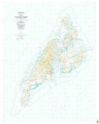 1983 Yap Islands (Waqab)1983 Print · USGSThe Yap Islands are captured in the early eighties as they transitioned into a new era of self-governance. Researchers can trace traditional village sites like Gagnagun and Bechiyal or locate landmarks such as St Josephs Church and the Yap Airport.
 - 1996 Map of Yap Islands (Waqab), 2003 Print
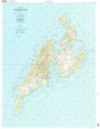 1996 Yap Islands (Waqab)2003 Print · USGSThe Yap Islands in the mid-1990s show a blend of traditional village life and modern infrastructure across the Federated States of Micronesia. Researchers can trace the coastal layout of Colonia, locate specific mission sites like Saint Joseph Church, and find historic Fish Traps near Wanyan.
End of results
Showing maps 1-2 of 2
Frequently asked questions
- What are the different types of historical maps available for Magachgil?
- What is the oldest map of Magachgil?
- Where can I purchase historical maps of Magachgil for my home or office?
- Where can I download high-res historical maps of Magachgil?
- Are there historical topographic maps available for Magachgil?
- Is there historical aerial imagery available for Magachgil?
- Where are historical maps of Magachgil sourced from?