1900s (20th Century) Maps of Sector Los Pagán, Adjuntas
Explore 4 historic maps of Sector Los Pagán from the 1900s (20th Century). These maps offer a rare glimpse into what life looked like during the 1900s — showing old roads, neighborhoods, homes, and landmarks that have changed or disappeared over time.
Whether you're researching your family's past, planning a metal detecting trip, or studying how Sector Los Pagán's landscape evolved across the 1900s, these high-resolution maps are a powerful tool for exploring the history of this region.
- Focus on a specific era: All maps on this page are from the 1900s, giving you a focused view of this time period.
- See what’s changed: Compare century-old streets, trails, and buildings to today's modern landscape using overlays and satellite layers.
- Research with precision: Use these maps for genealogy, historical research, land use analysis, or educational projects.
- View, download, or print: Maps are fully viewable online in high resolution, and can be downloaded or printed for your own records.
Start exploring Sector Los Pagán's history through authentic maps from the 1900s. This is your window into the past.
Sector Los Pagán, Adjuntas maps
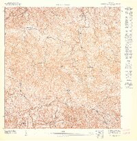
(4)- 1946 Map of Monte Guilarte
 1946 Monte Guilarte1946 Print · USGSThe mountain interior of Puerto Rico near Adjuntas is captured here in the mid-1940s, showing a landscape defined by traditional plantation estates. Researchers can trace dozens of family-named sites like Hacienda Juanita and Hacienda Rosario or locate local landmarks like the Iglesia Monserrate.3 unique versions available
 - 1947 Map of Monte Guilarte SE
 1947 Monte Guilarte SE1947 Print · USGSCentral Puerto Rico’s coffee-growing highlands come into focus in the late 1940s, showing the intersection of several mountain municipios. Genealogists and historians can trace family estates like Hacienda Esperanza and Hacienda Pietri near Monte Guilarte.
 - 1952 Map of Monte Guilarte, 1953 Print
 1952 Monte Guilarte1953 Print · USGSThe Cordillera Central mountains of Puerto Rico are mapped here in the early fifties during a period of robust rural agricultural life. Genealogists and historians can trace dozens of family estates, including Hacienda Indiera, Hacienda Balerosa, and the Hospital General de Castaner.2 unique versions available
 - 1960 Map of Monte Guilarte, 1962 Print
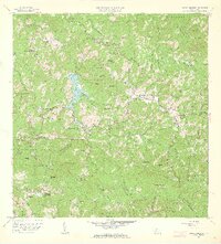 1960 Monte Guilarte1962 Print · USGSThe central highlands of Adjuntas and Lares are shown here in the early 1960s, a landscape defined by traditional mountain agriculture. Genealogists and historians can trace scores of family estates and rural institutions, from Hacienda Monserrate and Hacienda Buena Vista to the Escuela Mariana Bracetti.4 unique versions available
End of results
Showing maps 1-4 of 4
Top cities near Sector Los Pagán
- Ponce historical maps
- Yauco historical maps
- Sabana Grande historical maps
- San Sebastián historical maps
- Utuado historical maps
- Lares historical maps
See more
Frequently asked questions
- What are the different types of historical maps available for Sector Los Pagán?
- What is the oldest map of Sector Los Pagán?
- Where can I purchase historical maps of Sector Los Pagán for my home or office?
- Where can I download high-res historical maps of Sector Los Pagán?
- Are there historical topographic maps available for Sector Los Pagán?
- Is there historical aerial imagery available for Sector Los Pagán?
- Where are historical maps of Sector Los Pagán sourced from?