1900s (20th Century) Maps of Residencial Los Robles, Aguada
Explore 5 historic maps of Residencial Los Robles from the 1900s (20th Century). These maps offer a rare glimpse into what life looked like during the 1900s — showing old roads, neighborhoods, homes, and landmarks that have changed or disappeared over time.
Whether you're researching your family's past, planning a metal detecting trip, or studying how Residencial Los Robles's landscape evolved across the 1900s, these high-resolution maps are a powerful tool for exploring the history of this region.
- Focus on a specific era: All maps on this page are from the 1900s, giving you a focused view of this time period.
- See what’s changed: Compare century-old streets, trails, and buildings to today's modern landscape using overlays and satellite layers.
- Research with precision: Use these maps for genealogy, historical research, land use analysis, or educational projects.
- View, download, or print: Maps are fully viewable online in high resolution, and can be downloaded or printed for your own records.
Start exploring Residencial Los Robles's history through authentic maps from the 1900s. This is your window into the past.
Residencial Los Robles, Aguada maps
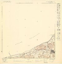
(5)- 1937 Map of Aguadilla
 1937 Aguadilla1937 Print · USGSNorthwestern Puerto Rico during the late 1930s reveals a landscape of coastal settlements and industrial rail lines. Genealogists and historians can trace the foundations of local communities through landmarks like the Iglesia de la Conception and the American railroad route through Coloso.
 - 1942 Map of Aguadilla
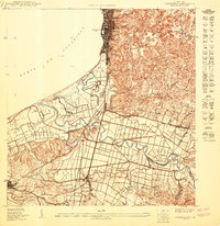
 1942 Aguadilla1942 Print · USGSCoastal life in northwest Puerto Rico during the early 1940s centered on the rail lines and rivers of the Aguadilla region. Genealogists and historians can trace family roots through the numerous railroad stops of the American Railroad or locate historical landmarks like the Pta Borinquen L H and the Iglesia Aguadilla.5 unique versions available
 - 1950 Map of Aguadilla SO
 1950 Aguadilla SO1950 Print · USGSAguada at the mid-century reveals a coastal landscape defined by the sugar-hauling American Railroad of Porto Rico and traditional barrios. Researchers can trace the original boundaries of Carrizal and Piedras Blancas or locate the historic Aguada Parada de Colón near the Atlantic shore.
 - 1950 Map of Aguadilla SE
 1950 Aguadilla SE1950 Print · USGSCoastal life in northwest Puerto Rico at mid-century is meticulously detailed where the mountains meet the Bahía de Aguadilla. Genealogists and historians can trace family locations through neighborhoods like Tamarindo, the path of the American Railroad, and rural schools like Escuela Segunda Unidad Espinal.
 - 1960 Map of Aguadilla, 1962 Print
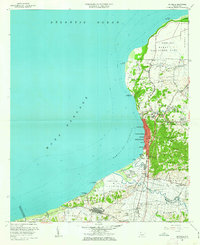 1960 Aguadilla1962 Print · USGSCoastal Aguadilla and the surrounding municipios are shown during a period of significant growth at the start of the 1960s. Researchers can trace the layout of Ramey Air Force Base, find local landmarks like Colegio San Carlos, or follow the Via Del Ferrocarril through Aguada.5 unique versions available
End of results
Showing maps 1-5 of 5
Frequently asked questions
- What are the different types of historical maps available for Residencial Los Robles?
- What is the oldest map of Residencial Los Robles?
- Where can I purchase historical maps of Residencial Los Robles for my home or office?
- Where can I download high-res historical maps of Residencial Los Robles?
- Are there historical topographic maps available for Residencial Los Robles?
- Is there historical aerial imagery available for Residencial Los Robles?
- Where are historical maps of Residencial Los Robles sourced from?