1960s Maps of Añasco
Explore 4 historic maps of Añasco from the 1960s. These maps offer a rare glimpse into what life looked like during the 1960s — showing old roads, neighborhoods, homes, and landmarks that have changed or disappeared over time.
Whether you're researching your family's past, planning a metal detecting trip, or studying how Añasco's landscape evolved across the 1960s, these high-resolution maps are a powerful tool for exploring the history of this region.
- Focus on a specific era: All maps on this page are from the 1960s, giving you a focused view of this time period.
- See what’s changed: Compare century-old streets, trails, and buildings to today's modern landscape using overlays and satellite layers.
- Research with precision: Use these maps for genealogy, historical research, land use analysis, or educational projects.
- View, download, or print: Maps are fully viewable online in high resolution, and can be downloaded or printed for your own records.
Start exploring Añasco's history through authentic maps from the 1960s. This is your window into the past.
Añasco maps
(4)- 1964 Map of Central La Plata, 1966 Print
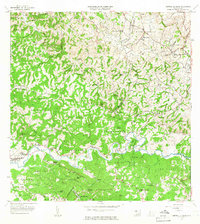 1964 Central La Plata1966 Print · USGSThe river valleys of western Puerto Rico are shown here in the mid-1960s as the traditional sugar economy transitioned. Genealogists can locate family-named estates like Hacienda Lamberti or trace the Via Ferrocarril Antigua through the hills.3 unique versions available
 - 1964 Map of Mayaguez, 1966 Print
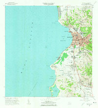 1964 Mayaguez1966 Print · USGSMayagüez and its surrounding coastal barrios are shown here in the mid-1960s as the region transitioned through industrial and academic growth. Trace the roots of local institutions like the University or find family landmarks in Hormigueros and Sabanetas.3 unique versions available
 - 1964 Map of Rosario, 1968 Print
 1964 Rosario1968 Print · USGSThe hill country of western Puerto Rico in the mid-sixties reveals a landscape of historic haciendas and emerging institutions. Genealogists and historians can locate family estates like Hacienda Retiro and community landmarks such as Capilla de Santa Ana or Escuela Mariano Abril.2 unique versions available
 - 1966 Map of Rincon, 1969 Print
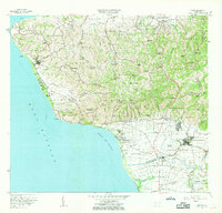 1966 Rincon1969 Print · USGSThe western tip of Puerto Rico at the mid-sixties shows a coast in transition between historic agriculture and modern infrastructure. Genealogists and historians can trace numerous rural schools and chapels like Capilla Santa Rita or the operations of the Central Igualdad sugar mill.2 unique versions available
End of results
Showing maps 1-4 of 4
Frequently asked questions
- What are the different types of historical maps available for Añasco?
- What is the oldest map of Añasco?
- Where can I purchase historical maps of Añasco for my home or office?
- Where can I download high-res historical maps of Añasco?
- Are there historical topographic maps available for Añasco?
- Is there historical aerial imagery available for Añasco?
- Where are historical maps of Añasco sourced from?