1950s Maps of Hato Abajo, Arecibo
Explore 5 historic maps of Hato Abajo from the 1950s. These maps offer a rare glimpse into what life looked like during the 1950s — showing old roads, neighborhoods, homes, and landmarks that have changed or disappeared over time.
Whether you're researching your family's past, planning a metal detecting trip, or studying how Hato Abajo's landscape evolved across the 1950s, these high-resolution maps are a powerful tool for exploring the history of this region.
- Focus on a specific era: All maps on this page are from the 1950s, giving you a focused view of this time period.
- See what’s changed: Compare century-old streets, trails, and buildings to today's modern landscape using overlays and satellite layers.
- Research with precision: Use these maps for genealogy, historical research, land use analysis, or educational projects.
- View, download, or print: Maps are fully viewable online in high resolution, and can be downloaded or printed for your own records.
Start exploring Hato Abajo's history through authentic maps from the 1950s. This is your window into the past.
Hato Abajo, Arecibo maps
(5)- 1950 Map of Camuy NE
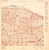 1950 Camuy NE1950 Print · USGSCoastal Hatillo and the surrounding barrios are captured in the mid-twentieth century as the rail lines still served the northern shore. Genealogists and historians can locate community centers like Lechuga and rural landmarks such as Iglesia Santa Teresita and the Escuela Eugenio María de Hostos.
 - 1950 Map of Arecibo NO
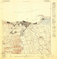 1950 Arecibo NO1950 Print · USGSCoastal Arecibo in the mid-twentieth century was a bustling nexus of sugar production and rail transport. Genealogists and historians can trace family roots through neighborhoods like Obrero or locate industrial sites like Central Cambalache and the American Railroad.
 - 1953 Map of Arecibo, 1954 Print
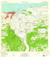
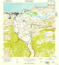 1953 Arecibo1954 Print · USGSArecibo and its coastal surroundings are shown in the early 1950s, a period when the sugar industry and railroads still shaped the local economy. Researchers can trace the lines of the American RR of Porto Rico connecting Central Cambalache and Central Los Caños with the coastal port.2 unique versions available
 - 1957 Map of Camuy, 1960 Print
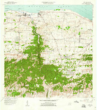 1957 Camuy1960 Print · USGSThe north coast of Puerto Rico is captured here in the late fifties, showing the development of coastal towns and rural hill settlements. Genealogists and historians can locate specific landmarks like Iglesia Santa Teresita, the Cementerio Municipal, and the winding course of the Río Camuy.2 unique versions available
 - 1957 Map of Arecibo, 1961 Print
 1957 Arecibo1961 Print · USGSPuerto Rico's northern coast comes alive in this mid-century survey, centered on the growing port and sugar economy. Researchers can trace the legacy of Central Cambalache, the old American Railroad, and landmarks like the Faro and Hospital Jefferson.
End of results
Showing maps 1-5 of 5
Frequently asked questions
- What are the different types of historical maps available for Hato Abajo?
- What is the oldest map of Hato Abajo?
- Where can I purchase historical maps of Hato Abajo for my home or office?
- Where can I download high-res historical maps of Hato Abajo?
- Are there historical topographic maps available for Hato Abajo?
- Is there historical aerial imagery available for Hato Abajo?
- Where are historical maps of Hato Abajo sourced from?