1900s (20th Century) Maps of Zoni, Culebra
Explore 2 historic maps of Zoni from the 1900s (20th Century). These maps offer a rare glimpse into what life looked like during the 1900s — showing old roads, neighborhoods, homes, and landmarks that have changed or disappeared over time.
Whether you're researching your family's past, planning a metal detecting trip, or studying how Zoni's landscape evolved across the 1900s, these high-resolution maps are a powerful tool for exploring the history of this region.
- Focus on a specific era: All maps on this page are from the 1900s, giving you a focused view of this time period.
- See what’s changed: Compare century-old streets, trails, and buildings to today's modern landscape using overlays and satellite layers.
- Research with precision: Use these maps for genealogy, historical research, land use analysis, or educational projects.
- View, download, or print: Maps are fully viewable online in high resolution, and can be downloaded or printed for your own records.
Start exploring Zoni's history through authentic maps from the 1900s. This is your window into the past.
Zoni, Culebra maps
(2)- 1948 Map of Culebra And Adjacent Islands, 1966 Print
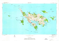 1948 Culebra And Adjacent Islands1966 Print · USGSCulebra and its surrounding cays are documented here just after the war, showing the island's maritime character and small coastal settlements. Researchers can trace the early layout of Culebra town, Playa Sardinas I, and the sheltered waters of Ensenada Honda.2 unique versions available
 - 1950 Map of Culebra And Adjacent Islands
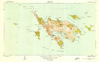 1950 Culebra And Adjacent Islands1950 Print · USGSThe island of Culebra and its surrounding cays are shown in detail at mid-century, highlighting the maritime importance of its deep-water harbors. Researchers can trace early shoreline settlements at Playa Sardinas I and geographic landmarks like Cayo Pirata and Península Flamenco.2 unique versions available
End of results
Showing maps 1-2 of 2
Top cities near Zoni
Frequently asked questions
- What are the different types of historical maps available for Zoni?
- What is the oldest map of Zoni?
- Where can I purchase historical maps of Zoni for my home or office?
- Where can I download high-res historical maps of Zoni?
- Are there historical topographic maps available for Zoni?
- Is there historical aerial imagery available for Zoni?
- Where are historical maps of Zoni sourced from?