1900s (20th Century) Maps of Machete, Guayama
Explore 10 historic maps of Machete from the 1900s (20th Century). These maps offer a rare glimpse into what life looked like during the 1900s — showing old roads, neighborhoods, homes, and landmarks that have changed or disappeared over time.
Whether you're researching your family's past, planning a metal detecting trip, or studying how Machete's landscape evolved across the 1900s, these high-resolution maps are a powerful tool for exploring the history of this region.
- Focus on a specific era: All maps on this page are from the 1900s, giving you a focused view of this time period.
- See what’s changed: Compare century-old streets, trails, and buildings to today's modern landscape using overlays and satellite layers.
- Research with precision: Use these maps for genealogy, historical research, land use analysis, or educational projects.
- View, download, or print: Maps are fully viewable online in high resolution, and can be downloaded or printed for your own records.
Start exploring Machete's history through authentic maps from the 1900s. This is your window into the past.
Machete, Guayama maps
(10)- 1945 Map of Central Aguirre
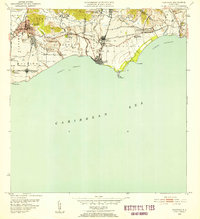
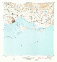 1945 Central Aguirre1945 Print · USGSThe southern coast of Puerto Rico was dominated by sugar production and coastal trade at the end of World War II. Researchers can trace the industrial infrastructure of Central Aguirre, the rail connections to Puerto Jobos, and old estates like Hacienda Mercedes.3 unique versions available
 - 1946 Map of Guayama
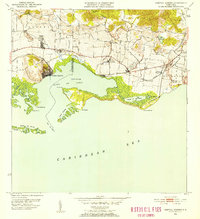
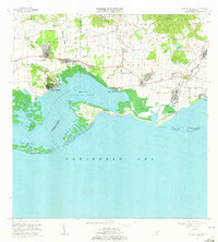
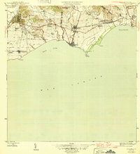 1946 Guayama1946 Print · USGSThe southern coast of Puerto Rico appears in the mid-1940s as a bustling center of sugar production and rail transport. Genealogists and historians can trace the estates of the day, from Central Machete to numerous family-named colonias like Hacienda Felicia.4 unique versions available
 - 1947 Map of Guayama NO
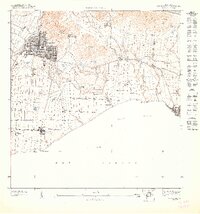 1947 Guayama NO1947 Print · USGSThe coastal sugar-producing region of Guayama is shown here just after the war, featuring a dense network of industrial haciendas and irrigation canals. Researchers can trace the boundaries of Central Machete and family-named agricultural sites like Hacienda Felicia and Colonia Pica.
 - 1947 Map of Central Aguirre NE
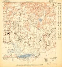 1947 Central Aguirre NE1947 Print · USGSGuayama’s southern coast in the late 1940s reveals a landscape shaped by the sugar industry and maritime trade. Researchers can trace the layout of the Central Guamani sugar mill and nearby estates like Hacienda Mercedes and Colonia Josefa.
 - 1952 Map of Guayama, 1953 Print
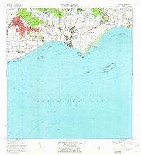
 1952 Guayama1953 Print · USGSCoastal Puerto Rico in the early fifties reveals a landscape shaped by sugar production and maritime trade. Local researchers can find named estates and industrial sites like Central Lafayette, Colonia Algarrobo, and the Faro Pta Figuras lighthouse.2 unique versions available
 - 1952 Map of Central Aguirre, 1953 Print
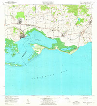
 1952 Central Aguirre1953 Print · USGSThe sugar-producing coastal plains of southern Puerto Rico are captured here in the early fifties, showcasing the vital infrastructure of the era. Genealogists and historians can trace the plantation economy through estate labels like Hacienda Mercedes, the port at Puerto Jobos, and the worker communities of Central Aguirre.2 unique versions available
 - 1960 Map of Central Aguirre, 1962 Print
 1960 Central Aguirre1962 Print · USGSThe sugar-producing coast of southern Puerto Rico comes alive in this mid-century survey of the Central Aguirre region. Genealogists can trace family roots through settlements like Coquí and San Felipe or locate local landmarks like the Colegio del Perpetuo Socorro and Central Guamaní.2 unique versions available
 - 1960 Map of Guayama, 1962 Print
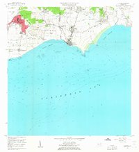 1960 Guayama1962 Print · USGSThe south coast of Puerto Rico in the 1960s reveals a region defined by its sugar industry and maritime trade. Researchers can trace family ties to landmarks like Central Lafayette, Hacienda Felicia, and the coastal lighthouse at Punta Figuras.2 unique versions available
 - 1970 Map of Central Aguirre, 1972 Print
 1970 Central Aguirre1972 Print · USGSThe southern coast of Puerto Rico comes alive in this 1970s survey of the sugar-producing heartland. Genealogists and historians can trace company town life at Central Aguirre and Coquí, or explore the maritime landscape of Bahía de Jobos and Las Mareas.3 unique versions available
 - 1970 Map of Guayama, 1972 Print
 1970 Guayama1972 Print · USGSThe southern coast of Puerto Rico thrived as a sugar and maritime hub in the early seventies. Genealogists and historians can trace the irrigation canals and residential expansion of Guayama or locate old industrial sites like Central Machete and Central Lafayette.4 unique versions available
End of results
Showing maps 1-10 of 10
Frequently asked questions
- What are the different types of historical maps available for Machete?
- What is the oldest map of Machete?
- Where can I purchase historical maps of Machete for my home or office?
- Where can I download high-res historical maps of Machete?
- Are there historical topographic maps available for Machete?
- Is there historical aerial imagery available for Machete?
- Where are historical maps of Machete sourced from?