1940s Maps of Sector Los Santiagos, Lares
Explore 2 historic maps of Sector Los Santiagos from the 1940s. These maps offer a rare glimpse into what life looked like during the 1940s — showing old roads, neighborhoods, homes, and landmarks that have changed or disappeared over time.
Whether you're researching your family's past, planning a metal detecting trip, or studying how Sector Los Santiagos's landscape evolved across the 1940s, these high-resolution maps are a powerful tool for exploring the history of this region.
- Focus on a specific era: All maps on this page are from the 1940s, giving you a focused view of this time period.
- See what’s changed: Compare century-old streets, trails, and buildings to today's modern landscape using overlays and satellite layers.
- Research with precision: Use these maps for genealogy, historical research, land use analysis, or educational projects.
- View, download, or print: Maps are fully viewable online in high resolution, and can be downloaded or printed for your own records.
Start exploring Sector Los Santiagos's history through authentic maps from the 1940s. This is your window into the past.
Sector Los Santiagos, Lares maps
(2)- 1946 Map of Bayaney
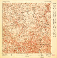
 1946 Bayaney1946 Print · USGSThe interior highlands of Puerto Rico are detailed here in the late 1940s, showcasing a landscape of isolated ridges and river-valley settlements. Researchers can trace local history through named rural schools like Escuela La America and settlements such as Angeles and Bayaney.4 unique versions available
 - 1947 Map of Bayaney NO
 1947 Bayaney NO1947 Print · USGSThe interior of northwestern Puerto Rico comes into focus in the late 1940s as rural communities began to expand. Genealogists and researchers can trace the specific boundaries of the Municipio de Lares and locate local landmarks like the Escuela Theodore Roosevelt.
End of results
Showing maps 1-2 of 2
Top cities near Sector Los Santiagos
- Arecibo historical maps
- Isabela historical maps
- San Sebastián historical maps
- Utuado historical maps
- Quebradillas historical maps
- Lares historical maps
See more
Frequently asked questions
- What are the different types of historical maps available for Sector Los Santiagos?
- What is the oldest map of Sector Los Santiagos?
- Where can I purchase historical maps of Sector Los Santiagos for my home or office?
- Where can I download high-res historical maps of Sector Los Santiagos?
- Are there historical topographic maps available for Sector Los Santiagos?
- Is there historical aerial imagery available for Sector Los Santiagos?
- Where are historical maps of Sector Los Santiagos sourced from?