1900s (20th Century) Maps of Maunabo
Explore 14 historic maps of Maunabo from the 1900s (20th Century). These maps offer a rare glimpse into what life looked like during the 1900s — showing old roads, neighborhoods, homes, and landmarks that have changed or disappeared over time.
Whether you're researching your family's past, planning a metal detecting trip, or studying how Maunabo's landscape evolved across the 1900s, these high-resolution maps are a powerful tool for exploring the history of this region.
- Focus on a specific era: All maps on this page are from the 1900s, giving you a focused view of this time period.
- See what’s changed: Compare century-old streets, trails, and buildings to today's modern landscape using overlays and satellite layers.
- Research with precision: Use these maps for genealogy, historical research, land use analysis, or educational projects.
- View, download, or print: Maps are fully viewable online in high resolution, and can be downloaded or printed for your own records.
Start exploring Maunabo's history through authentic maps from the 1900s. This is your window into the past.
Maunabo maps
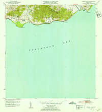
(14)- 1945 Map of Punta Tuna
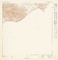
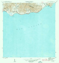 1945 Punta Tuna1945 Print · USGSCoastal Maunabo and Patillas appear here just after the war, showing the southeastern shoreline before modern development. Genealogists and historians can locate the Faro lighthouse at Pta Tuna, the Hacienda San Isidro, and the Escuela Segunda Unidad de Guardarraya.4 unique versions available
 - 1946 Map of Punta Guayanes
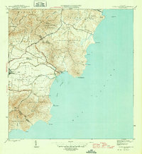 1946 Punta Guayanes1946 Print · USGSThe coastal sugar and rail landscape of eastern Puerto Rico is captured here in the mid-1940s. Genealogists and historians can trace the industrial footprint of Central Roig and find old settlements like Colonia Monserrate and Playa de Guayanes.3 unique versions available
 - 1946 Map of Yabucoa
 1946 Yabucoa1946 Print · USGSSoutheastern Puerto Rico during the mid-forties reveals a landscape defined by its sugar industry and coastal mountains. Genealogists and historians can trace the social geography of the era through the locations of Central Roig, Colonia Laura, and the heights of Cerro La Pandura.3 unique versions available
 - 1947 Map of Yabucoa SO
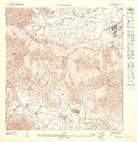
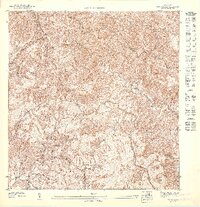 1947 Yabucoa SO1947 Print · USGSThe mountainous interior of southeastern Puerto Rico is captured here in the late 1940s as rural life followed the winding paths of the southern sierras. Genealogists and historians can trace the steep ridgelines of Pico Lebron or follow the waters of the Rio Maunabo and Quebrada Chinos.
 - 1947 Map of Punta Tuna NO
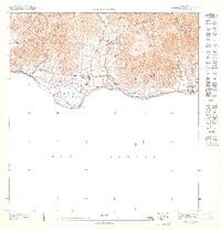 1947 Punta Tuna NO1947 Print · USGSThe southern coast of Puerto Rico during the 1940s reveals a landscape of agricultural estates and mountain ridges. Researchers can trace the legacy of Hacienda San Isidro or locate the Escuela Segunda Unidad de Guardarraya near the Rio Jacaboa.
 - 1947 Map of Yabucoa SE
 1947 Yabucoa SE1947 Print · USGSSoutheastern Puerto Rico is captured here in the 1940s, showing the agricultural heart of the coastal valleys. Genealogists can trace family lands near Colonia Garonne, the industrial site at Central Columbia, and the street grids of Yabucoa.
 - 1947 Map of Punta Tuna NE
 1947 Punta Tuna NE1947 Print · USGSSoutheastern Puerto Rico's coastline in the late 1940s reveals a landscape defined by dramatic mountain ridges and the Caribbean Sea. Researchers can trace the rugged topography of the Sierra de Guardarraya and locate the historic Faro at Pta Tuna.
 - 1947 Map of Punta Guayanes SO
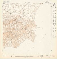 1947 Punta Guayanes SO1947 Print · USGSSoutheast Puerto Rico in the late 1940s reveals a landscape of sugar production and coastal navigation. Genealogists and historians can trace the roads near Central Roig or locate coastal landmarks like Pta Yeguas and the Pyramid Beacon.
 - 1952 Map of Yabucoa, 1953 Print
 1952 Yabucoa1953 Print · USGSSoutheastern Puerto Rico is documented here in the early fifties, showing the vibrant sugar-mill economy and coastal settlements of the era. Genealogists and researchers can trace local families through sites like Central Roig, Parcelas Martorell, and the Escuela C S Ridley.2 unique versions available
 - 1952 Map of Punta Guayanes, 1953 Print
 1952 Punta Guayanes1953 Print · USGSSoutheast Puerto Rico’s coastline in the early fifties shows a vibrant agricultural and maritime landscape centered around the sugar industry. Genealogists and historians can trace family locations in Colonia Monserrate, Playa de Guayanes, and near the industrial site of Central Roig.2 unique versions available
 - 1952 Map of Punta Tuna, 1953 Print
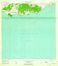
 1952 Punta Tuna1953 Print · USGSMaunabo's rugged coastline and the high peaks of the Sierra Palo Seco are captured here during the early fifties. Genealogists and researchers can locate the Faro at Pta Tuna, the Hacienda San Isidro, and several named barrios and schools along the coast.2 unique versions available
 - 1960 Map of Yabucoa, 1961 Print
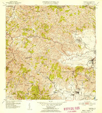
 1960 Yabucoa1961 Print · USGSSoutheastern Puerto Rico is mapped here in the early sixties, showing the vital sugar industry and mountain settlements before modern expansion. Genealogists can locate family sites like Laura and Columbia, or local institutions such as Escuela Matías Sánchez and Central Roig.3 unique versions available
 - 1960 Map of Punta Tuna, 1961 Print
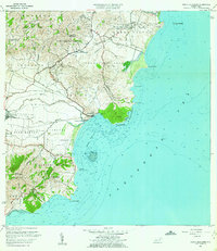
 1960 Punta Tuna1961 Print · USGSSoutheast Puerto Rico meets the sea in the early sixties, showing the transition from mountain ridges to the Caribbean coast. Genealogists and historians can trace the estates of Hacienda San Isidro, the landmark Faro Punta Tuna, and the village of Recio.2 unique versions available
 - 1960 Map of Punta Guayanes, 1962 Print
 1960 Punta Guayanes1962 Print · USGSThe Yabucoa coastline in the early sixties reveals a landscape shaped by sugar production and rural commerce. Genealogists and historians can locate former schools like Escuela Asunción Lopez and trace the sugar infrastructure of Central Roig.6 unique versions available
End of results
Showing maps 1-14 of 14
Frequently asked questions
- What are the different types of historical maps available for Maunabo?
- What is the oldest map of Maunabo?
- Where can I purchase historical maps of Maunabo for my home or office?
- Where can I download high-res historical maps of Maunabo?
- Are there historical topographic maps available for Maunabo?
- Is there historical aerial imagery available for Maunabo?
- Where are historical maps of Maunabo sourced from?