Old Maps of Salinas for Academic Research
Study the evolution of Salinas with 38 high-resolution historic maps. Whether you're teaching, researching, or modeling changes in land use, these maps provide essential visual documentation of urban, environmental, and geographic change.
- Analyze long-term change: Track patterns in development, transportation, and natural features.
- Ideal for environmental or urban studies: Support academic projects with primary historical map data.
- Use in the classroom or lab: Educators and researchers rely on these maps to bring historical context to life.
These maps are a powerful tool for teaching, research, and visualizing how Salinas has changed over the decades.
Salinas maps
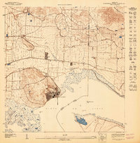
(38)- 1945 Map of Central Aguirre
 1945 Central Aguirre1945 Print · USGSThe southern coast of Puerto Rico was dominated by sugar production and coastal trade at the end of World War II. Researchers can trace the industrial infrastructure of Central Aguirre, the rail connections to Puerto Jobos, and old estates like Hacienda Mercedes.3 unique versions available
 - 1945 Map of Salinas
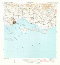
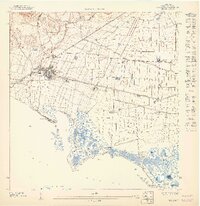
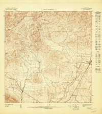
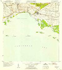
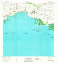
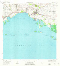
 1945 Salinas1945 Print · USGSThe southern coast of Puerto Rico comes alive in this mid-century survey of the sugar-driven economy and maritime geography. Genealogists and historians can trace the legacy of local estates like Hacienda Margarita and the industrial hub at Central Caribe.2 unique versions available
 - 1946 Map of Coamo
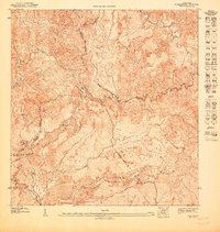
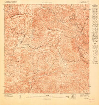
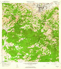
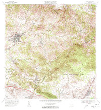
 1946 Coamo1946 Print · USGSThe town of Coamo and its surrounding haciendas are captured in the mid-1940s just as the historic mountain roads were modernizing. Genealogists and local historians can locate family estates like Hacienda Esmeralda and Hacienda San José or trace the route to Baños de Coamo.
 - 1946 Map of Cayey
 1946 Cayey1946 Print · USGSThe central mountains of Puerto Rico are captured here in the mid-1940s, centered on the growing town of Cayey. Local historians can trace agricultural roots at Hacienda Clavell and Hacienda Julia, or locate early religious landmarks like the Capilla de Santa Maria.2 unique versions available
 - 1947 Map of Cayey NO
 1947 Cayey NO1947 Print · USGSThe mountain interior of Puerto Rico is captured here in the 1940s, showing the intersection of four municipalities along the Cordillera Central. Researchers can trace the steep terrain around Las Tetas and the early layout of Proyecto Vazquez and Vertedero.
 - 1947 Map of Cayey SO
 1947 Cayey SO1947 Print · USGSSouthern Puerto Rico was defined by traditional estates and military land use in the mid-1940s. Genealogists and historians can trace the foundations of local life at Hacienda Clavell, the settlement at La Plena, and the Capilla de Santa Marta.
 - 1947 Map of Salinas NE
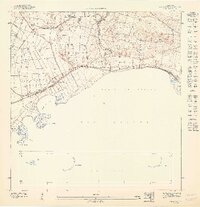
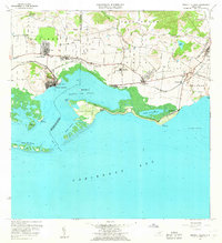
 1947 Salinas NE1947 Print · USGSCoastal Puerto Rico's sugar-driven economy is on full display in the 1940s as rail lines and irrigation canals crisscross the plains. Genealogists can locate specific estates like Hacienda Teresa and Colonia Esperanza near the town of Salinas.
 - 1947 Map of Central Aquirre SO
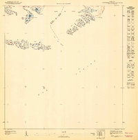 1947 Central Aquirre SO1947 Print · USGSThe southern coast of Puerto Rico is revealed in the mid-1940s as a complex network of bays and cays. Coastal historians can trace the municipal boundary between Salinas and Guayama through the Boca del Infierno and the many islets of the Cayos de Barca.
 - 1947 Map of Coamo SO
 1947 Coamo SO1947 Print · USGSSouthern Puerto Rico's historic thermal springs and plantation estates are captured here in the late 1940s as the agricultural landscape evolved. Researchers can locate named estates and settlements like Hacienda Esmeralda, Baños de Coamo, and Colonia Peñuelas.
 - 1947 Map of Coamo NE
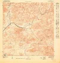
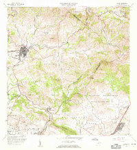
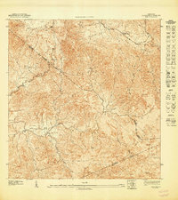 1947 Coamo NE1947 Print · USGSThe Puerto Rican interior in the late 1940s is shown here along the high ridges of the Cordillera Central. Trace rural life near the Escuela Federico Degetau and the settlements of Jácana and La Guaba before modern development altered the valley floors.
 - 1947 Map of Coamo SE
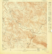
 1947 Coamo SE1947 Print · USGSThe rural landscape of Salinas and Coamo is documented here just after the war, showing a region of traditional haciendas and military installations. Researchers can locate the grounds of Hacienda Lago and trace the paths of Río Jueyes and Río Majada.
 - 1947 Map of Cayey SE
 1947 Cayey SE1947 Print · USGSThe highland borders of Cayey, Salinas, and Guayama are captured in the late 1940s just as the rural interior began to modernize. Genealogists and historians can trace family locations near the Poblado Carmen settlement or landmarks like the Capilla de San Giraldo and Cerro Garau.
 - 1947 Map of Central Aquirre NO
 1947 Central Aquirre NO1947 Print · USGSThe sugar-producing coast of southern Puerto Rico comes to life in the 1940s as the industry reached its peak. Researchers can trace the industrial layout of Central Aguirre, the worker housing at Coquí, and the vital irrigation of the Canal de Patillas.
 - 1947 Map of Salinas NO
 1947 Salinas NO1947 Print · USGSThe southern coast of Puerto Rico is captured here in the 1940s, highlighting the region's deep ties to coastal agriculture and the sea. Researchers can trace the layout of Hacienda Palés, the Canal de Juana Díaz, and the offshore Arrecife Media Luna.
 - 1952 Map of Salinas, 1953 Print
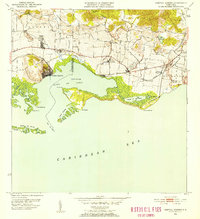
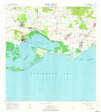
 1952 Salinas1953 Print · USGSThe southern coast of Puerto Rico is captured here in the early 1950s, a landscape defined by sugar haciendas and the Caribbean shoreline. Genealogists and historians can locate family-named estates like Hacienda Pales and trace the sugar economy at Central Caribe.2 unique versions available
 - 1952 Map of Central Aguirre, 1953 Print
 1952 Central Aguirre1953 Print · USGSThe sugar-producing coastal plains of southern Puerto Rico are captured here in the early fifties, showcasing the vital infrastructure of the era. Genealogists and historians can trace the plantation economy through estate labels like Hacienda Mercedes, the port at Puerto Jobos, and the worker communities of Central Aguirre.2 unique versions available
 - 1952 Map of Coamo, 1953 Print
 1952 Coamo1953 Print · USGSMid-century Puerto Rico is captured here during a period of transition between its historic hacienda economy and modern development. Researchers can trace family roots through named estates like Hacienda Esmeralda or visit the famous thermal springs at Baños de Coamo.2 unique versions available
 - 1953 Map of Cayey
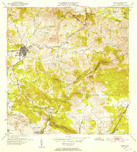
 1953 Cayey1953 Print · USGSThe mountain town of Cayey and its surrounding barrios are documented here in the early 1950s during a period of transition and growth. Researchers can trace land ownership and community centers through labels for Hacienda Clavell, Poblado Carmen, and the Iglesia Sagrado Corazon.2 unique versions available
 - 1960 Map of Salinas, 1962 Print
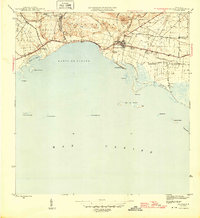
 1960 Salinas1962 Print · USGSThe southern coast of Puerto Rico is captured here in the early sixties, showing the agricultural and maritime life of the region. Researchers can trace land holdings like Hacienda Teresa or locate the mid-century Aeropuerto de Salinas.2 unique versions available
 - 1960 Map of Central Aguirre, 1962 Print
 1960 Central Aguirre1962 Print · USGSThe sugar-producing coast of southern Puerto Rico comes alive in this mid-century survey of the Central Aguirre region. Genealogists can trace family roots through settlements like Coquí and San Felipe or locate local landmarks like the Colegio del Perpetuo Socorro and Central Guamaní.2 unique versions available
 - 1960 Map of Cayey, 1962 Print
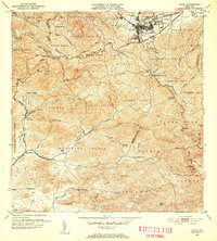
 1960 Cayey1962 Print · USGSCayey was transitioning from an agrarian mountain outpost to a regional hub during the early sixties. Genealogists can trace family footprints across several named estates, including Hacienda Julia and Hacienda Clavell, and locate old landmarks like the Capilla de Santa Marta.
 - 1960 Map of Coamo, 1962 Print
 1960 Coamo1962 Print · USGSThe southern foothills of the Cordillera Central come into focus in the early sixties, centered on the growing town of Coamo. Researchers can locate historic agricultural sites like Hacienda Buena Vista or trace the boundaries of the Salinas Training Area.2 unique versions available
 - 1970 Map of Salinas, 1972 Print
 1970 Salinas1972 Print · USGSThe southern coast of Puerto Rico is captured here in the early seventies, detailing the transition from mountain foothills to the Caribbean. Trace historic family estates like Hacienda Carmen or explore coastal features like Mar Negro and the Aeropuerto de Salinas.4 unique versions available
 - 1970 Map of Central Aguirre, 1972 Print
 1970 Central Aguirre1972 Print · USGSThe southern coast of Puerto Rico comes alive in this 1970s survey of the sugar-producing heartland. Genealogists and historians can trace company town life at Central Aguirre and Coquí, or explore the maritime landscape of Bahía de Jobos and Las Mareas.3 unique versions available
 - 1972 Map of Coamo, 1973 Print
 1972 Coamo1973 Print · USGSThe town of Coamo sits at the edge of the Cordillera Central in the early seventies, showing a landscape of traditional haciendas and modern military training grounds. Genealogists can locate family names and sites like Hacienda Buena Vista, San Diego, and the Escuela Federico Degetau.3 unique versions available
Showing maps 1-25 of 38
Frequently asked questions
- What are the different types of historical maps available for Salinas?
- What is the oldest map of Salinas?
- Where can I purchase historical maps of Salinas for my home or office?
- Where can I download high-res historical maps of Salinas?
- Are there historical topographic maps available for Salinas?
- Is there historical aerial imagery available for Salinas?
- Where are historical maps of Salinas sourced from?