Old Maps of Fareham, Saint Croix District for Hiking & Exploration
Hike through history with 3 historic maps of Fareham. Explore old trails, ghost towns, and forgotten backroads — perfect for outdoor adventurers and local explorers.
- Rediscover forgotten places: Map out old mining camps, roads, and footpaths that no longer exist on modern maps.
- Layer with modern tools: Combine with LiDAR or satellite views to plan hikes through historical terrain.
- Made for exploration: Popular among hikers, overlanders, and local history lovers.
Use these maps to find adventure and explore the hidden past of Fareham.
Fareham, Saint Croix District maps
(3)- 1958 Map of East Point, 1959 Print
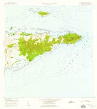 1958 East Point1959 Print · USGSThe eastern reaches of Saint Croix are captured in the late fifties, showing a landscape of traditional estates and rugged coastal topography. Genealogists can trace family landholdings and small settlements like All for the Better, Sallys Fancy, and Madame Carty.5 unique versions available
 - 2013 Map of Christiansted, 2013 Print
 2013 Christiansted2013 Print · USGSCovers Fareham, including Longford (Anna's Hope Village), Work and Rest, and other nearby areas
 - 2024 Map of Christiansted, 2024 Print
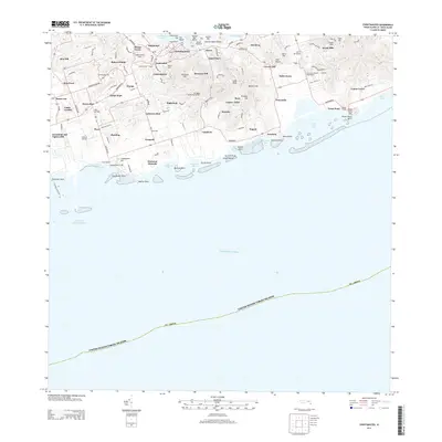
 2024 Christiansted2024 Print · USGSSaint Croix's northern coast and central hills are detailed here in the mid-2020s, showing the intersection of colonial history and modern development. Researchers can trace historic estate boundaries and sites like Bulows Minde, the Danish Cem, and Friedensthal.
End of results
Showing maps 1-3 of 3
Frequently asked questions
- What are the different types of historical maps available for Fareham?
- What is the oldest map of Fareham?
- Where can I purchase historical maps of Fareham for my home or office?
- Where can I download high-res historical maps of Fareham?
- Are there historical topographic maps available for Fareham?
- Is there historical aerial imagery available for Fareham?
- Where are historical maps of Fareham sourced from?