Old Maps of Grange, Saint Croix District for Academic Research
Study the evolution of Grange with 3 high-resolution historic maps. Whether you're teaching, researching, or modeling changes in land use, these maps provide essential visual documentation of urban, environmental, and geographic change.
- Analyze long-term change: Track patterns in development, transportation, and natural features.
- Ideal for environmental or urban studies: Support academic projects with primary historical map data.
- Use in the classroom or lab: Educators and researchers rely on these maps to bring historical context to life.
These maps are a powerful tool for teaching, research, and visualizing how Grange has changed over the decades.
Grange, Saint Croix District maps
(3)- 1958 Map of Christiansted, 1959 Print
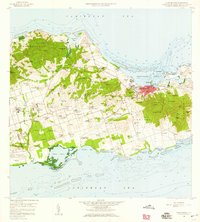 1958 Christiansted1959 Print · USGSSaint Croix's mid-century landscape is captured here just as the island began its modern growth phase. Researchers can trace the layout of Christiansted, locate family names among settlements like Sion Hill and Belvedere, and find landmarks like Kingshill Sch and the Alexander Hamilton Airport.6 unique versions available
 - 2013 Map of Christiansted, 2013 Print
 2013 Christiansted2013 Print · USGSCovers Grange, including Longford (Anna's Hope Village), Work and Rest, and other nearby areas
 - 2024 Map of Christiansted, 2024 Print
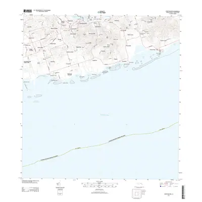
 2024 Christiansted2024 Print · USGSSaint Croix's northern coast and central hills are detailed here in the mid-2020s, showing the intersection of colonial history and modern development. Researchers can trace historic estate boundaries and sites like Bulows Minde, the Danish Cem, and Friedensthal.
End of results
Showing maps 1-3 of 3
Frequently asked questions
- What are the different types of historical maps available for Grange?
- What is the oldest map of Grange?
- Where can I purchase historical maps of Grange for my home or office?
- Where can I download high-res historical maps of Grange?
- Are there historical topographic maps available for Grange?
- Is there historical aerial imagery available for Grange?
- Where are historical maps of Grange sourced from?