Old Maps of Morningstar, Saint Croix District for Hiking & Exploration
Hike through history with 3 historic maps of Morningstar. Explore old trails, ghost towns, and forgotten backroads — perfect for outdoor adventurers and local explorers.
- Rediscover forgotten places: Map out old mining camps, roads, and footpaths that no longer exist on modern maps.
- Layer with modern tools: Combine with LiDAR or satellite views to plan hikes through historical terrain.
- Made for exploration: Popular among hikers, overlanders, and local history lovers.
Use these maps to find adventure and explore the hidden past of Morningstar.
Morningstar, Saint Croix District maps
(3)- 1958 Map of Christiansted, 1959 Print
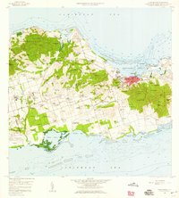 1958 Christiansted1959 Print · USGSSaint Croix's mid-century landscape is captured here just as the island began its modern growth phase. Researchers can trace the layout of Christiansted, locate family names among settlements like Sion Hill and Belvedere, and find landmarks like Kingshill Sch and the Alexander Hamilton Airport.6 unique versions available
 - 2013 Map of Baron Bluff, 2013 Print
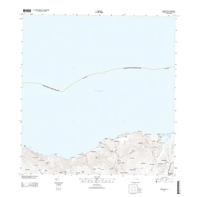 2013 Baron Bluff2013 Print · USGSCovers Morningstar, including Little Fountain, Annaly, and other nearby areas
 - 2024 Map of Baron Bluff, 2024 Print
 2024 Baron Bluff2024 Print · USGSSaint Croix's northern coast is mapped here in the early twenty-first century, showcasing its steep ridges and historic estates. Genealogists and historians can trace traditional land names from Annaly to Morningstar and locate the Salt River Bay National Historical Park.
End of results
Showing maps 1-3 of 3
Frequently asked questions
- What are the different types of historical maps available for Morningstar?
- What is the oldest map of Morningstar?
- Where can I purchase historical maps of Morningstar for my home or office?
- Where can I download high-res historical maps of Morningstar?
- Are there historical topographic maps available for Morningstar?
- Is there historical aerial imagery available for Morningstar?
- Where are historical maps of Morningstar sourced from?