1970s Maps of Joppa, Alabama
Explore 2 historic maps of Joppa from the 1970s. These maps offer a rare glimpse into what life looked like during the 1970s — showing old roads, neighborhoods, homes, and landmarks that have changed or disappeared over time.
Whether you're researching your family's past, planning a metal detecting trip, or studying how Joppa's landscape evolved across the 1970s, these high-resolution maps are a powerful tool for exploring the history of this region.
- Focus on a specific era: All maps on this page are from the 1970s, giving you a focused view of this time period.
- See what’s changed: Compare century-old streets, trails, and buildings to today's modern landscape using overlays and satellite layers.
- Research with precision: Use these maps for genealogy, historical research, land use analysis, or educational projects.
- View, download, or print: Maps are fully viewable online in high resolution, and can be downloaded or printed for your own records.
Start exploring Joppa's history through authentic maps from the 1970s. This is your window into the past.
Joppa, AL maps
(2)- 1975 Map of Hulaco, 1977 Print
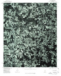 1975 Hulaco1977 Print · USGSThe rural landscape around the Cullman and Marshall county line is captured in the mid-seventies, showing the region's transformation into a modern agricultural hub. Researchers can pinpoint property boundaries and land use near settlements like Hulaco, Joppa, and the outskirts of Arab.
 - 1976 Map of Hulaco, 1977 Print
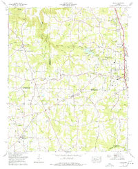 1976 Hulaco1977 Print · USGSNorth Alabama crossroads and family-run lands are captured here in the mid-1970s just as towns like Arab began to expand. Genealogists can trace family names and sites through Hebron Church, Crawford Cem, and the old settlement of Hulaco.
End of results
Showing maps 1-2 of 2
Top cities near Joppa
- Cullman historical maps
- Guntersville historical maps
- Arab historical maps
- Hanceville historical maps
- New Hope historical maps
- Blountsville historical maps
See more
Frequently asked questions
- What are the different types of historical maps available for Joppa?
- What is the oldest map of Joppa?
- Where can I purchase historical maps of Joppa for my home or office?
- Where can I download high-res historical maps of Joppa?
- Are there historical topographic maps available for Joppa?
- Is there historical aerial imagery available for Joppa?
- Where are historical maps of Joppa sourced from?